Difference between revisions of "2019-09-13 52 9"
From Geohashing
(New Expedition) |
|||
| Line 41: | Line 41: | ||
{{land geohash|latitude=52|longitude=9|date=2019-09-13|name=[[User:Fippe|Fippe]]|image=2019-09-13 52 09 04 Geohash.jpg}} | {{land geohash|latitude=52|longitude=9|date=2019-09-13|name=[[User:Fippe|Fippe]]|image=2019-09-13 52 09 04 Geohash.jpg}} | ||
{{OpenStreetMap achievement|latitude=52|longitude=9|date=2019-09-13|OSMlink=74473407}} | {{OpenStreetMap achievement|latitude=52|longitude=9|date=2019-09-13|OSMlink=74473407}} | ||
| + | {{Dark Ages|latitude=52|longitude=9|date=2019-09-13|name=[[User:Fippe|Fippe]]}} | ||
__NOTOC__ | __NOTOC__ | ||
Revision as of 18:07, 31 March 2020
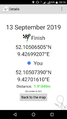
| Fri 13 Sep 2019 in Hannover: 52.1050651, 9.4269921 geohashing.info google osm bing/os kml crox |
Location
This Geohash is located on a field in Afferde.
Participants
Expedition
Day 13 of the Geohashing Wiki being offline.
From Hannover, I took the train to Hameln, and walked the rest of the distance from there.
I walked through Afferde and eventually arrived at a part of the street where a smaller path led to a wind turbine. The Geohash was in a field next to the path. I located the coordinates, recorded proof and left the field again.
Afterwards, I walked back to the train station, and took the train back to Hannover.
Photos

In Hameln

In Afferde
Proof

The Geohash
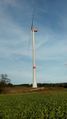
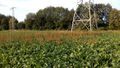
The Wind Turbine
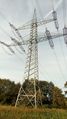
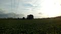
The Transmission Tower
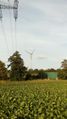
The second Wind Turbine
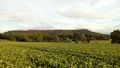
Surroundings
Surroundings
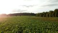
Surroundings
Surroundings


Ribbons
Fippe earned the Land geohash achievement
|
This user earned the OpenStreetMap achievement
|

Fippe earned the Dark Ages achievement
by going on an expedition to the (52, 9) geohash on 2019-09-13.