Difference between revisions of "2020-01-12 51 3"
FelixTheCat (talk | contribs) (Created page with "{{subst:Expedition |lat = 51 |lon = 3 |date = 2020-01-12 }}") |
FelixTheCat (talk | contribs) |
||
| Line 1: | Line 1: | ||
| − | |||
| − | |||
| − | |||
| − | |||
| − | |||
| − | |||
| − | |||
| − | |||
| − | |||
| − | |||
{{meetup graticule | {{meetup graticule | ||
| lat=51 | | lat=51 | ||
| Line 14: | Line 4: | ||
| date=2020-01-12 | | date=2020-01-12 | ||
}} | }} | ||
| − | |||
| − | |||
__NOTOC__ | __NOTOC__ | ||
== Location == | == Location == | ||
| − | + | In a park called ''Punt van Goeree'', Ouddorp, South Holland province. | |
== Participants == | == Participants == | ||
| − | + | [[User:FelixTheCat|FelixTheCat]] ([[User talk:FelixTheCat|talk]]) and Kat the Awesome | |
| − | |||
| − | |||
| − | |||
| − | |||
== Expedition == | == Expedition == | ||
| − | + | It was Sunday and the weather was good, which made it easy for me to convince Kat to go for a walk in a remote corner of South Holland (right on the border with Zeeland). We drove there and parked at a small car park serving a seaside restaurant. We then walked towards the hash. The location was very nice: a kind of park/forest location with wide open spaces, interesting water features and a view over Lake Grevelingen (which used to be part of the North Sea but is now a saltwater lake). We found the hash, which was just on the edge of the water. We then walked around some more, exploring an interesting area nearby where several bunkers from the Second World War were preserved. After that, we went to the seaside restaurant for a snack, and then went home again. | |
| − | |||
| − | |||
| − | |||
== Photos == | == Photos == | ||
| Line 39: | Line 20: | ||
--> | --> | ||
<gallery perrow="5"> | <gallery perrow="5"> | ||
| + | Image:2020-01-12 51 3 FelixTheCat 1.JPG | The car park. There's also a huge mobile communications tower. | ||
| + | Image:2020-01-12 51 3 FelixTheCat 2.JPG | The sign says "no horses allowed". So we had to smuggle in our dear Lloyd. | ||
| + | Image:2020-01-12 51 3 FelixTheCat 3.JPG | The park contained this interesting water feature, where the footpath (just on the left edge of the picture) dives into the water, then makes a right turn and emerges again at the bottom of the stairs. | ||
| + | Image:2020-01-12 51 3 FelixTheCat 4.JPG | The hash is up ahead, on the edge of the water. | ||
| + | Image:2020-01-12 51 3 FelixTheCat 5.JPG | Right here it is. | ||
| + | Image:2020-01-12 51 3 FelixTheCat 6.png | GPS proof. | ||
| + | Image:2020-01-12 51 3 FelixTheCat 7.JPG | Lloyd celebrating (quietly). | ||
| + | Image:2020-01-12 51 3 FelixTheCat 8.JPG | Nearby was this cluster of bunkers, some including gun turrets. | ||
</gallery> | </gallery> | ||
== Achievements == | == Achievements == | ||
{{#vardefine:ribbonwidth|800px}} | {{#vardefine:ribbonwidth|800px}} | ||
| − | + | {{land geohash | |
| + | | latitude = 51 | ||
| + | | longitude = 3 | ||
| + | | date = 2020-01-12 | ||
| + | | name = [[User:FelixTheCat|FelixTheCat]] ([[User talk:FelixTheCat|talk]]) and Kat | ||
| + | }} | ||
| − | |||
| − | |||
| − | |||
| − | |||
| − | |||
| − | |||
| − | |||
| − | |||
| − | |||
| − | |||
| − | |||
| − | |||
| − | |||
| − | |||
[[Category:Expeditions]] | [[Category:Expeditions]] | ||
| − | |||
[[Category:Expeditions with photos]] | [[Category:Expeditions with photos]] | ||
| − | |||
| − | |||
| − | |||
| − | |||
| − | |||
[[Category:Coordinates reached]] | [[Category:Coordinates reached]] | ||
| − | |||
| − | |||
| − | |||
| − | |||
| − | |||
| − | |||
| − | |||
| − | |||
| − | |||
| − | |||
| − | |||
| − | |||
| − | |||
| − | |||
| − | |||
| − | |||
| − | |||
| − | |||
Revision as of 13:32, 4 February 2020
| Sun 12 Jan 2020 in 51,3: 51.7822587, 3.8916517 geohashing.info google osm bing/os kml crox |
Location
In a park called Punt van Goeree, Ouddorp, South Holland province.
Participants
FelixTheCat (talk) and Kat the Awesome
Expedition
It was Sunday and the weather was good, which made it easy for me to convince Kat to go for a walk in a remote corner of South Holland (right on the border with Zeeland). We drove there and parked at a small car park serving a seaside restaurant. We then walked towards the hash. The location was very nice: a kind of park/forest location with wide open spaces, interesting water features and a view over Lake Grevelingen (which used to be part of the North Sea but is now a saltwater lake). We found the hash, which was just on the edge of the water. We then walked around some more, exploring an interesting area nearby where several bunkers from the Second World War were preserved. After that, we went to the seaside restaurant for a snack, and then went home again.
Photos
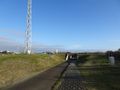
The car park. There's also a huge mobile communications tower.
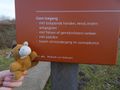
The sign says "no horses allowed". So we had to smuggle in our dear Lloyd.
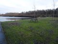
The park contained this interesting water feature, where the footpath (just on the left edge of the picture) dives into the water, then makes a right turn and emerges again at the bottom of the stairs.
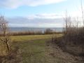
The hash is up ahead, on the edge of the water.
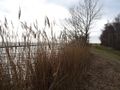
Right here it is.
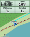
GPS proof.
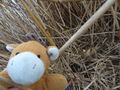
Lloyd celebrating (quietly).
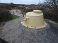
Nearby was this cluster of bunkers, some including gun turrets.


Achievements
FelixTheCat (talk) and Kat earned the Land geohash achievement
|