Difference between revisions of "2020-02-13 35 -105"
m (expedition stub and track) |
m (try out user cat template) |
||
| (12 intermediate revisions by 2 users not shown) | |||
| Line 21: | Line 21: | ||
== Expedition == | == Expedition == | ||
Failed, which I'm actually glad about -- I'll edit this page I think tomorrow with why, and the story and photos. | Failed, which I'm actually glad about -- I'll edit this page I think tomorrow with why, and the story and photos. | ||
| + | |||
| + | edit @ 2020-07-28: I guess it's "tomorrow"? Probably more that I got over whatever it was keeping me from writing it up. Like many of my hash attempts and non-attempts, this one began as a struggle between my desire for adventure and laziness. I booted up [[geohashing.info]] somewhat early in the morning (I try to check when the Dow opens, which is usually 07:30 my time), but between going back and forth on whether it was worth it and making myself lunch and generally procrastinating, the day wore on into the afternoon. | ||
| + | |||
| + | Eventually a combination of reverse psychology and...direct psychology?... shook me out of that local minima: my mother noted that I could walk southwest along the Galisteo Creek riverbed (in response to me complaining that while I could get vaguely close to the hash from two different roads, one heading south initially and the other heading west initially, but neither were ''that'' close or particularly scenic) which seemed nice (see previous section), and later also remarked that it was probably getting too late to do it -- which of course galvanised me to try, even if it meant walking back in the darkness. | ||
| + | |||
| + | Also operative in my motivation was the misconception that the creek would be publically-owned land. Generally there is a sense of communal ownership of waterways in this region (see for instance https://santafewatershed.org/education or [[wikidata:Q97819689]]) However, I encountered many fences crossing the streambed, some with gates latched only with a chain (thanks to those landowners thoughtful enough to install such amenities, I promise I left them as I found them) but some I had to hop over or slither under. Also, the stream became more and more riparian; compared to the extents near my house, which are wide and sandy, it was crowded with trees and shrubs nearer Galisteo proper, and had a tighter course. Also, any time gained by heading in a straighter line overall was lost by needing to follow some of the meanders of the river (which I anticipated in the last section but somehow didn't understand the implications of; even cutting some corners to avoid the worst of the [[wikipedia:en:coastline paradox|coastline paradox]], which of course lowered the hydrological data value of the tracklog‡, I found myself doubling back a lot since far extents of the river were not visible through the plant life). Eventually I saw some houses close to the creek, decided the trip as embarked upon wasn't legit, and borrowed someone's driveway to find my way back to the main road to Galisteo, via which I returned to Lamy just as night fell. | ||
| + | |||
| + | I also considered as I walked back how important safety-oriented thinking truly is; when geohashing there's always a danger of getting mauled by a bear or someone's dogs or shot in the face, hence the [[geohashing: general disclaimer]], but one should take whatever steps to ameliorate such risks. In particular, my choice in this case to walk along the stream meant that, had I run into a sticky situation, I would be less accessible to roadgoing emergency vehicles, for instance. | ||
| + | |||
| + | Such thoughts did little to distract from the beauty of the countryside of Santa Fe County, however (see next section). And I got to do some [[geotrashing]], picking up some narrow road bike tires doubtless discarded from a local bicycle race, the 'Santa Fe Century'. | ||
| + | |||
| + | ‡I did correct the river name as part of redoing the overall relation; not sure if I can claim an [[OpenStreetMap achievement]] for this expedition however. | ||
== Tracklog == | == Tracklog == | ||
| − | [[osmuser:Arlo%20James%20Barnes/traces/3213971]] | + | {{tracklog|2020-02-13 35 -105.gpx}} also known as [[:osmuser:Arlo%20James%20Barnes/traces/3213971]] |
== Photos == | == Photos == | ||
| − | |||
| − | |||
| − | |||
<gallery perrow="5"> | <gallery perrow="5"> | ||
| + | file:2020-02-13 35 -105 eroded stream wall 1.jpg | Soon the creek had carved the landscape to an appreciable depth. | ||
| + | file:2020-02-13 35 -105 eroded stream wall 2.jpg | Exposed vertical culvert and torn transmission pipes. | ||
| + | file:2020-02-13 35 -105 highway 41 sunset.jpg | Blurry sunset. Note downed US-285 sign in the lower left. | ||
| + | file:2020-02-13 35 -105 sign 1.jpg | custom speed limit sign | ||
</gallery> | </gallery> | ||
== Achievements == | == Achievements == | ||
{{#vardefine:ribbonwidth|800px}} | {{#vardefine:ribbonwidth|800px}} | ||
| − | |||
| − | |||
| − | |||
| − | |||
| − | |||
| − | + | {{prize poultry | |
| + | | latitude = 35 | ||
| + | | longitude = -105 | ||
| + | | date = 2020-02-13 | ||
| + | | name = Arlo | ||
| + | | reason = it seemed like the right thing to do | ||
| + | | image = | ||
| + | }} | ||
| − | + | {{location|US|NM|ST}} | |
| − | |||
| − | |||
| − | |||
| − | + | [[category:expeditions]] | |
| − | + | [[category:coordinates not reached]] | |
| − | |||
| − | |||
| − | |||
| − | |||
| − | |||
| − | |||
| − | |||
| − | |||
| − | [[ | ||
| − | + | [[category:expeditions with photos]] | |
| − | |||
| − | |||
| − | |||
| − | |||
| − | |||
| − | |||
| − | [[ | ||
| − | + | [[category:not reached - No public access]] | |
| − | |||
| − | |||
| − | |||
| − | [[ | ||
| − | + | {{user categories|user=Arlo|foot=1}} | |
Latest revision as of 15:32, 16 February 2022
| Thu 13 Feb 2020 in 35,-105: 35.4109433, -105.9149982 geohashing.info google osm bing/os kml crox |
Location
Between a road (Avenida Vieja) and the dike on the south side of the Galisteo Creek (horrifyingly, misspelled as Galesteo River on OSM, so that'll be an easy gimme for the OSM achievement after) in a green-looking area.
Participants
Plans
Walk from Lamy to near the hash down the creek (opportunity to align creek to tracklog better than the imported geohydrology dataset does probably), then climb over dike, then hit up hash and walk to Galisteo along road and follow NM41 back to 285 and Lamy before supper.
Expedition
Failed, which I'm actually glad about -- I'll edit this page I think tomorrow with why, and the story and photos.
edit @ 2020-07-28: I guess it's "tomorrow"? Probably more that I got over whatever it was keeping me from writing it up. Like many of my hash attempts and non-attempts, this one began as a struggle between my desire for adventure and laziness. I booted up geohashing.info somewhat early in the morning (I try to check when the Dow opens, which is usually 07:30 my time), but between going back and forth on whether it was worth it and making myself lunch and generally procrastinating, the day wore on into the afternoon.
Eventually a combination of reverse psychology and...direct psychology?... shook me out of that local minima: my mother noted that I could walk southwest along the Galisteo Creek riverbed (in response to me complaining that while I could get vaguely close to the hash from two different roads, one heading south initially and the other heading west initially, but neither were that close or particularly scenic) which seemed nice (see previous section), and later also remarked that it was probably getting too late to do it -- which of course galvanised me to try, even if it meant walking back in the darkness.
Also operative in my motivation was the misconception that the creek would be publically-owned land. Generally there is a sense of communal ownership of waterways in this region (see for instance https://santafewatershed.org/education or wikidata:Q97819689) However, I encountered many fences crossing the streambed, some with gates latched only with a chain (thanks to those landowners thoughtful enough to install such amenities, I promise I left them as I found them) but some I had to hop over or slither under. Also, the stream became more and more riparian; compared to the extents near my house, which are wide and sandy, it was crowded with trees and shrubs nearer Galisteo proper, and had a tighter course. Also, any time gained by heading in a straighter line overall was lost by needing to follow some of the meanders of the river (which I anticipated in the last section but somehow didn't understand the implications of; even cutting some corners to avoid the worst of the coastline paradox, which of course lowered the hydrological data value of the tracklog‡, I found myself doubling back a lot since far extents of the river were not visible through the plant life). Eventually I saw some houses close to the creek, decided the trip as embarked upon wasn't legit, and borrowed someone's driveway to find my way back to the main road to Galisteo, via which I returned to Lamy just as night fell.
I also considered as I walked back how important safety-oriented thinking truly is; when geohashing there's always a danger of getting mauled by a bear or someone's dogs or shot in the face, hence the geohashing: general disclaimer, but one should take whatever steps to ameliorate such risks. In particular, my choice in this case to walk along the stream meant that, had I run into a sticky situation, I would be less accessible to roadgoing emergency vehicles, for instance.
Such thoughts did little to distract from the beauty of the countryside of Santa Fe County, however (see next section). And I got to do some geotrashing, picking up some narrow road bike tires doubtless discarded from a local bicycle race, the 'Santa Fe Century'.
‡I did correct the river name as part of redoing the overall relation; not sure if I can claim an OpenStreetMap achievement for this expedition however.
Tracklog
also known as osmuser:Arlo James Barnes/traces/3213971
Photos
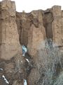
Soon the creek had carved the landscape to an appreciable depth.
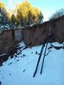
Exposed vertical culvert and torn transmission pipes.
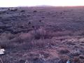
Blurry sunset. Note downed US-285 sign in the lower left.
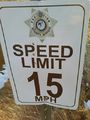
custom speed limit sign


Achievements
Arlo earned the Prize poultry Consolation Prize
|