Difference between revisions of "2020-02-23 53 -2"
m (→Photos & Video: add photos) |
m (adjust categories) |
||
| (11 intermediate revisions by the same user not shown) | |||
| Line 17: | Line 17: | ||
{{location|GB|ENG|SKP}} | {{location|GB|ENG|SKP}} | ||
| − | == Photos | + | == Expedition == |
| + | [[User:KarMann|KarMann]] was off to a nice start, catching the first bus at just the right time. While on the bus, he discovered that he hadn't put his SD card back in his camera after the last time he downloaded pictures from it, rendering both the camera and the tripod dead weight he'd have to carry along. Oh well, the phone takes pictures well enough for this. | ||
| + | |||
| + | After disembarking from the bus, he made his way towards the so-called Roman Lakes where the hashpoint seemed to lie. Along the way, the woods were looking lovely, but then the road crossed the River Goyt, which was in full spate this day. Undeterred, he carried on to the tea room. Oh, the ordeal! | ||
| + | |||
| + | Planning to take a way around the water to the north of the tea room, he found his first obstacle. The bridge over the stream was blocked off with a sign warning of tree maintenance, presumably after the recent Storms Ciara & Dennis. OK, he'd anticipated there might be some such roadblocks. Not to worry; he had contingency plans. | ||
| + | |||
| + | So he roamed around a bit to the south, where a finger of land seemed like it might connect to a point where he could get to the path that should take him near enough to the hashpoint. But, fingers have tips, and this one ended at it, like all good fingers do. Time to turn around and try another approach. | ||
| + | |||
| + | After going around again, and then rather farther to the south, he found a way over the stream, where it passed through a little culvert. Crossed at last! And then he saw the mud around the first gate to pass through. Not to worry, he'd come prepared for the likes of this, too. Waterproof boots and gaiters would see him through the probable gators. | ||
| + | |||
| + | Having waded through the mud, and scrambled up a bit of muddy hillside, he then found that, after all that, there was a fence between him and the also-muddy path that might go in generally the right direction. If he could get to the other side of that fence, it might be a fairly easy shot across a clear field most of the way to the hashpoint. But, the fence had barbed wire, and looked to be electrified on the other side. He'd brought his drone along in case he could get nearly there but not quite, but the wind was too strong for flying. Defeated at last, he turned back, pausing to admire the viaduct from a suitable angle. | ||
| + | |||
| + | Along the way out, going to a different bus stop than the one he'd alighted at, he found he was going up quite a hill. Since he was still recovering from a torn ACL injury, this was not at the top of his list of things to do, but then, a failed return home would be even worse than a failed expedition. Getting up the hill a bit, he then found stairs to be climbed, even worse for the knee than the hill. But, getting up towards the top, he did notice some little stalactites in an archway built into the side of the viaduct, which felt nicely like getting a [[Going deep geohash achievement]]. | ||
| + | |||
| + | Back at the bus stop, a bit of a wait, and an uneventful return home. Expedition failed, but interesting, at least. If he'd known about the obstacles on the chosen approach, he might have tried going in from the northeast instead, where there's a campground and golf club which would have probably allowed easier access. | ||
| + | |||
| + | == Tracklog == | ||
| + | * [[File:2020-02-23 53 -2.gpx]] | ||
| + | * [https://www.wikiloc.com/hiking-trails/roman-lakes-geohash-2020-02-23-53-2-47184253 Wikiloc GPX track] of bus & hiking. | ||
| + | |||
| + | == Photos == | ||
<gallery perrow="5"> | <gallery perrow="5"> | ||
Image:2020-02-23 53 -2 Empty camera.jpg|Not an auspicious start. I forgot to bring the SD card for my camera. It and the tripod are now just dead weight I'm going to have to lug around with me. | Image:2020-02-23 53 -2 Empty camera.jpg|Not an auspicious start. I forgot to bring the SD card for my camera. It and the tripod are now just dead weight I'm going to have to lug around with me. | ||
| Line 25: | Line 46: | ||
Image:2020-02-23 53 -2 Geese.jpg|Uh oh. They have <strike>geese</strike> dinosaurs guarding the hashpoint. | Image:2020-02-23 53 -2 Geese.jpg|Uh oh. They have <strike>geese</strike> dinosaurs guarding the hashpoint. | ||
Image:2020-02-23 53 -2 Cone.jpg|OK, I guess I won't be reaching the hashpoint that way. Still, there are plenty of other ways around to it, right? | Image:2020-02-23 53 -2 Cone.jpg|OK, I guess I won't be reaching the hashpoint that way. Still, there are plenty of other ways around to it, right? | ||
| + | Image:2020-02-23 53 -2 GPS first.png|So this is as close as I'm getting this way. And, as it would turn out, any way. | ||
| + | Image:2020-02-23 53 -2 Stream pano 1.jpg|So that stream is right between me and the hashpoint. And the path to the left is also blocked off. But there must be some way over or around it, right? | ||
| + | Image:2020-02-23 53 -2 Bower.jpg|Perhaps this is a conveniently located portal to the hashpoint? | ||
| + | Image:2020-02-23 53 -2 Bower isle.jpg|No, that's definitely a dead end. | ||
| + | Image:2020-02-23 53 -2 Bower pano.jpg|There's only one way back and out from here. I'll see where I can go from there. | ||
| + | Image:2020-02-23 53 -2 GPS 2.png|I'm not exactly getting closer, am I? | ||
| + | Image:2020-02-23 53 -2 Way over.jpg|At last! A way over this bit of the stream! | ||
| + | Image:2020-02-23 53 -2 Mud gate.jpg|Which brings me to this. Oh, joy. | ||
| + | Image:2020-02-23 53 -2 Gaiters.jpg|There might be gaiters! I may not have been prepared for the worst, but at least I was prepared for the worse. | ||
| + | Image:2020-02-23 53 -2 Muddy fence.jpg|And after working my way through that mud, and up a muddy hill, I found this fence still between myself and the hashpoint, and with mud on the other side of it. Did I mention there was mud? | ||
| + | Image:2020-02-23 53 -2 GPS 3.png|Still farther away than the last two. | ||
| + | Image:2020-02-23 53 -2 Defeat.jpg|That doesn't look like the requisite goofy grin, does it? | ||
| + | Image:2020-02-23 53 -2 Revenge of the mud.jpg|And now I get to go through this all over again. Oh, that might explain the lack of a goofy grin, mightn't it? | ||
| + | Image:2020-02-23 53 -2 Viaduct.jpg|At least there are some interesting features around here. This viaduct carries the trains over the Goyt Valley here. I think it's still in service, although I didn't see any today. | ||
| + | Image:2020-02-23 53 -2 Distant hashpoint.jpg|Somewhere up that hill, amongst those trees, lies a hashpoint that I just couldn't reach. | ||
| + | Image:2020-02-23 53 -2 Stalactites.jpg|On the exitpedition, I noticed these little stalactites hanging in an archway built into the viaduct. It feels almost like getting a [[Going deep geohash achievement]]! | ||
| + | Image:2020-02-23 53 -2 Stairs.jpg|Oh goody. On the way out, I get to go up a hillside to get back to the road where the bus stop is, and then up some stairs. (I'm recovering from tearing my ACL, so stairs are not my friend.) | ||
| + | Image:2020-02-23 53 -2 More stairs.jpg|And then, just to add insult to injury, rather literally… | ||
</gallery> | </gallery> | ||
| + | |||
| + | === Video === | ||
| + | * A little cascade along the railway on the way back, and the stairs I faced. | ||
| + | : <youtube>https://youtu.be/R-d2X5vAe_Y</youtube> | ||
| + | |||
| + | == Achievements == | ||
| + | {{Public transport geohash | ||
| + | | latitude = 53 | ||
| + | | longitude = -2 | ||
| + | | date = 2020-02-23 | ||
| + | | busline = Stagecoach Bus 383 | ||
| + | | name = [[User:KarMann|KarMann]] | ||
| + | | image = 2020-02-23 53 -2 Bus stop.jpg | ||
| + | }} | ||
| + | {{My kingdom for a boat | ||
| + | | latitude = 53 | ||
| + | | longitude = -2 | ||
| + | | date = 2020-02-23 | ||
| + | | name = [[User:KarMann|KarMann]] | ||
| + | | waterhazard = swollen stream | ||
| + | | image = 2020-02-23 53 -2 Ominous stream.jpg | ||
| + | }} | ||
| + | {{There might be alligators! | ||
| + | | latitude = 53 | ||
| + | | longitude = -2 | ||
| + | | date = 2020-02-23 | ||
| + | | name = [[User:KarMann|KarMann]] | ||
| + | | hazard = flooded out path | ||
| + | | image = 2020-02-23 53 -2 Mud gate.jpg | ||
| + | }} | ||
| + | |||
| + | [[Category:Expeditions]] | ||
| + | [[Category:Expeditions with photos]] | ||
| + | [[Category:Coordinates not reached]] | ||
| + | [[Category:Not reached - Mother Nature]] | ||
Latest revision as of 23:03, 2 March 2020
| Sun 23 Feb 2020 in Manchester, UK: 53.3868933, -2.0434446 geohashing.info google osm bing/os kml crox |
Contents
Location
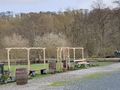
The hashpoint for today is in the wood near a golf course by Marple. I believe it's within the borders of the Roman Lakes Leisure Park. No admission fee, so no Admit One achievement. There are streams in the area, but there seems to be a bit of the path on the right side of the streams to reach the hashpoint.
Participants
Plans
KarMann is going to catch a bus to get there around 13:50, but the last couple of hundred metres may be treacherous.
Expedition
KarMann was off to a nice start, catching the first bus at just the right time. While on the bus, he discovered that he hadn't put his SD card back in his camera after the last time he downloaded pictures from it, rendering both the camera and the tripod dead weight he'd have to carry along. Oh well, the phone takes pictures well enough for this.
After disembarking from the bus, he made his way towards the so-called Roman Lakes where the hashpoint seemed to lie. Along the way, the woods were looking lovely, but then the road crossed the River Goyt, which was in full spate this day. Undeterred, he carried on to the tea room. Oh, the ordeal!
Planning to take a way around the water to the north of the tea room, he found his first obstacle. The bridge over the stream was blocked off with a sign warning of tree maintenance, presumably after the recent Storms Ciara & Dennis. OK, he'd anticipated there might be some such roadblocks. Not to worry; he had contingency plans.
So he roamed around a bit to the south, where a finger of land seemed like it might connect to a point where he could get to the path that should take him near enough to the hashpoint. But, fingers have tips, and this one ended at it, like all good fingers do. Time to turn around and try another approach.
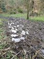
After going around again, and then rather farther to the south, he found a way over the stream, where it passed through a little culvert. Crossed at last! And then he saw the mud around the first gate to pass through. Not to worry, he'd come prepared for the likes of this, too. Waterproof boots and gaiters would see him through the probable gators.
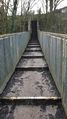
Having waded through the mud, and scrambled up a bit of muddy hillside, he then found that, after all that, there was a fence between him and the also-muddy path that might go in generally the right direction. If he could get to the other side of that fence, it might be a fairly easy shot across a clear field most of the way to the hashpoint. But, the fence had barbed wire, and looked to be electrified on the other side. He'd brought his drone along in case he could get nearly there but not quite, but the wind was too strong for flying. Defeated at last, he turned back, pausing to admire the viaduct from a suitable angle.
Along the way out, going to a different bus stop than the one he'd alighted at, he found he was going up quite a hill. Since he was still recovering from a torn ACL injury, this was not at the top of his list of things to do, but then, a failed return home would be even worse than a failed expedition. Getting up the hill a bit, he then found stairs to be climbed, even worse for the knee than the hill. But, getting up towards the top, he did notice some little stalactites in an archway built into the side of the viaduct, which felt nicely like getting a Going deep geohash achievement.
Back at the bus stop, a bit of a wait, and an uneventful return home. Expedition failed, but interesting, at least. If he'd known about the obstacles on the chosen approach, he might have tried going in from the northeast instead, where there's a campground and golf club which would have probably allowed easier access.
Tracklog
- File:2020-02-23 53 -2.gpx
- Wikiloc GPX track of bus & hiking.
Photos
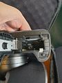
Not an auspicious start. I forgot to bring the SD card for my camera. It and the tripod are now just dead weight I'm going to have to lug around with me.
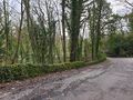
But this does look rather nice. This just might be a lovely walk in the woods today.
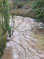
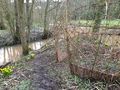
Oh my. That stream does look rather swollen and rough, doesn't it?
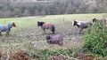
Are you sure there isn't a 'my kingdom for a horse' consolation prize? Not even anything about battery staples?
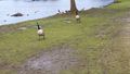
Uh oh. They have
geesedinosaurs guarding the hashpoint.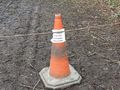
OK, I guess I won't be reaching the hashpoint that way. Still, there are plenty of other ways around to it, right?
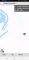
So this is as close as I'm getting this way. And, as it would turn out, any way.
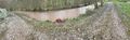
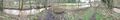
So that stream is right between me and the hashpoint. And the path to the left is also blocked off. But there must be some way over or around it, right?
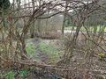
Perhaps this is a conveniently located portal to the hashpoint?
No, that's definitely a dead end.
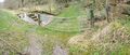
There's only one way back and out from here. I'll see where I can go from there.

I'm not exactly getting closer, am I?
At last! A way over this bit of the stream!
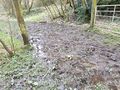
Which brings me to this. Oh, joy.
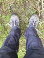
There might be gaiters! I may not have been prepared for the worst, but at least I was prepared for the worse.
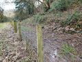
And after working my way through that mud, and up a muddy hill, I found this fence still between myself and the hashpoint, and with mud on the other side of it. Did I mention there was mud?
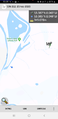
Still farther away than the last two.

That doesn't look like the requisite goofy grin, does it?
And now I get to go through this all over again. Oh, that might explain the lack of a goofy grin, mightn't it?

At least there are some interesting features around here. This viaduct carries the trains over the Goyt Valley here. I think it's still in service, although I didn't see any today.
Somewhere up that hill, amongst those trees, lies a hashpoint that I just couldn't reach.
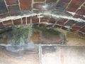
On the exitpedition, I noticed these little stalactites hanging in an archway built into the viaduct. It feels almost like getting a Going deep geohash achievement!
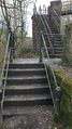
Oh goody. On the way out, I get to go up a hillside to get back to the road where the bus stop is, and then up some stairs. (I'm recovering from tearing my ACL, so stairs are not my friend.)
And then, just to add insult to injury, rather literally…


Video
- A little cascade along the railway on the way back, and the stairs I faced.
Achievements
KarMann earned the Public transport geohash achievement
|
KarMann earned the My kingdom for a boat consolation prize
|
KarMann earned the There might be alligators! consolation prize
|