Difference between revisions of "2020-02-25 51 4"
FelixTheCat (talk | contribs) (Created page with "{{subst:Expedition |lat = 51 |lon = 4 |date = 2020-02-25 }}") |
FelixTheCat (talk | contribs) |
||
| Line 1: | Line 1: | ||
| − | + | {{meetup graticule | |
| − | |||
| − | |||
| − | |||
| − | |||
| − | |||
| − | |||
| − | |||
| − | |||
| lat=51 | | lat=51 | ||
| lon=4 | | lon=4 | ||
| date=2020-02-25 | | date=2020-02-25 | ||
| − | }} | + | }} |
__NOTOC__ | __NOTOC__ | ||
== Location == | == Location == | ||
| − | + | On a bike path in Capelle aan den IJssel, Zuid Holland province. | |
== Participants == | == Participants == | ||
| − | + | [[User:FelixTheCat|FelixTheCat]] ([[User talk:FelixTheCat|talk]]) | |
| − | |||
| − | |||
| − | |||
| − | |||
== Expedition == | == Expedition == | ||
| − | + | The sun was shining (finally) and there was an accessible hashpoint within cycling distance. So I pumped my tyres and oiled my chain, and set off. There was quite a bit of wind, but it was blowing in roughly the right direction so the way there was fast and easy. Once at the hash I took some pictures, and then rode home again, using a somewhat different route. It was much heavier because the wind was now working against me, but I made it home safely. | |
== Tracklog == | == Tracklog == | ||
| − | + | {{tracklog | 2020-02-25 51 4 FelixTheCat.gpx}} | |
== Photos == | == Photos == | ||
| − | |||
| − | |||
| − | |||
<gallery perrow="5"> | <gallery perrow="5"> | ||
| + | Image:2020-02-25 51 4 FelixTheCat 1.JPG | Riding through the polders, past windmill De Valk. | ||
| + | Image:2020-02-25 51 4 FelixTheCat 2.JPG | Who turned off the pumps??? This is what you get when you forget to drain the land in this area. In this case it was probably deliberate, since there were major roadworks nearby and they might need to change the groundwater level for that. | ||
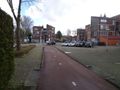
| + | Image:2020-02-25 51 4 FelixTheCat 3.JPG | We're getting near Capelle. Note that red-and-white signs show the way for cyclists. Blue-and-white is for motorized traffic. | ||
| + | Image:2020-02-25 51 4 FelixTheCat 4.JPG | The hash path. It's called Vlinderpad (Butterfly path). | ||
| + | Image:2020-02-25 51 4 FelixTheCat 5.png | GPS proof. | ||
| + | Image:2020-02-25 51 4 FelixTheCat 6.JPG | Lloyd and Harriet celebrating. | ||
| + | Image:2020-02-25 51 4 FelixTheCat 7.JPG | Looking west. | ||
| + | Image:2020-02-25 51 4 FelixTheCat 8.JPG | On the way back, I encountered a mountain bike trail and decided to ride it for a bit. | ||
</gallery> | </gallery> | ||
== Achievements == | == Achievements == | ||
{{#vardefine:ribbonwidth|800px}} | {{#vardefine:ribbonwidth|800px}} | ||
| − | + | {{bicycle geohash | |
| − | + | | latitude = 51 | |
| − | + | | longitude = 4 | |
| − | + | | date = 2020-02-25 | |
| − | [[ | + | | name = [[User:FelixTheCat|FelixTheCat]] ([[User talk:FelixTheCat|talk]]) |
| − | + | | distance = 49.5 km | |
| − | + | | bothways = true | |
| − | + | }} | |
| − | |||
| − | |||
| − | [[ | ||
| − | |||
| − | |||
| − | |||
| − | |||
| − | |||
[[Category:Expeditions]] | [[Category:Expeditions]] | ||
| − | |||
[[Category:Expeditions with photos]] | [[Category:Expeditions with photos]] | ||
| − | |||
| − | |||
| − | |||
| − | |||
| − | |||
[[Category:Coordinates reached]] | [[Category:Coordinates reached]] | ||
| − | |||
| − | |||
| − | |||
| − | |||
| − | |||
| − | |||
| − | |||
| − | |||
| − | |||
| − | |||
| − | |||
| − | |||
| − | |||
| − | |||
| − | |||
| − | |||
| − | |||
| − | |||
Revision as of 13:38, 25 February 2020
| Tue 25 Feb 2020 in 51,4: 51.9529231, 4.5903916 geohashing.info google osm bing/os kml crox |
Location
On a bike path in Capelle aan den IJssel, Zuid Holland province.
Participants
Expedition
The sun was shining (finally) and there was an accessible hashpoint within cycling distance. So I pumped my tyres and oiled my chain, and set off. There was quite a bit of wind, but it was blowing in roughly the right direction so the way there was fast and easy. Once at the hash I took some pictures, and then rode home again, using a somewhat different route. It was much heavier because the wind was now working against me, but I made it home safely.
Tracklog
Photos
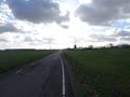
Riding through the polders, past windmill De Valk.
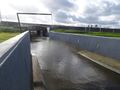
Who turned off the pumps??? This is what you get when you forget to drain the land in this area. In this case it was probably deliberate, since there were major roadworks nearby and they might need to change the groundwater level for that.
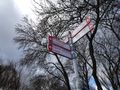
We're getting near Capelle. Note that red-and-white signs show the way for cyclists. Blue-and-white is for motorized traffic.
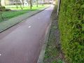
The hash path. It's called Vlinderpad (Butterfly path).
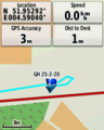
GPS proof.
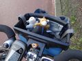
Lloyd and Harriet celebrating.
Looking west.
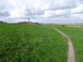
On the way back, I encountered a mountain bike trail and decided to ride it for a bit.


Achievements
FelixTheCat (talk) earned the Bicycle geohash achievement
|