Difference between revisions of "2020-02-28 42 -71"
(Creating page template) |
m |
||
| (8 intermediate revisions by 2 users not shown) | |||
| Line 15: | Line 15: | ||
== Location == | == Location == | ||
<!-- where you've surveyed the hash to be --> | <!-- where you've surveyed the hash to be --> | ||
| + | Walpole, MA, in the woods/yard near Old Post Rd, Polley Ln, and Moose Hill Rd. | ||
== Participants == | == Participants == | ||
<!-- who attended: If you link to your wiki user name in this section, your expedition will be picked up by the various statistics generated for geohashing. You may use three tildes ~ as a shortcut to automatically insert the user signature of the account you are editing with. | <!-- who attended: If you link to your wiki user name in this section, your expedition will be picked up by the various statistics generated for geohashing. You may use three tildes ~ as a shortcut to automatically insert the user signature of the account you are editing with. | ||
--> | --> | ||
| + | |||
| + | [[User:Azsr|azsr]] | ||
== Plans == | == Plans == | ||
<!-- what were the original plans --> | <!-- what were the original plans --> | ||
| + | [[User:Azsr|azsr]]: I'm planning to leave from Ruggles at about 2:30 pm, taking the Orange Line to Forest Hills, then transferring onto the 34E bus. ETA is about 4:00 pm. | ||
== Expedition == | == Expedition == | ||
<!-- how it all turned out. your narrative goes here. --> | <!-- how it all turned out. your narrative goes here. --> | ||
| + | |||
| + | [[User:Azsr|azsr]]: I started from the Orange Line Mass Ave station at about 3:20, taking a southbound train to Forest Hills. From there, I transferred directly onto a 34E bus. I got off the bus one stop too early (trigger finger on the "request stop" button!) and so had to walk about 5 minutes more than I needed to. | ||
| + | |||
| + | I got to the geohash right around 4 pm and stapled my poster to a tree on Old Post Rd. Then, I got as close as I could to the geohash itself (which was in the yard of four houses). My GPS signal was pretty jittery, so I'm not sure I actually was on the geohash at any point, but I was definitely within 5-10 m of it. | ||
| + | |||
| + | The ride back home was essentially the same in reverse, but I had timed the return trip poorly, so I had to wait almost 25 min for the bus (it operates at 30 min intervals). However, this gave me the great opportunity to walk through the nearby Bird Park, which, as I found out, is not a park specifically for birds, but is named after a certain Mr. Bird. | ||
== Tracklog == | == Tracklog == | ||
| Line 34: | Line 44: | ||
--> | --> | ||
<gallery perrow="5"> | <gallery perrow="5"> | ||
| + | Image:20200228 azsr selfie.jpg | The poster and azsr | ||
| + | Image:20200228 azsr gps.jpg | Ehh... close enough (?) | ||
| + | Image:20200228 azsr turkeys.jpg | A flock of turkeys not too far from the geohash | ||
</gallery> | </gallery> | ||
| Line 40: | Line 53: | ||
<!-- Add any achievement ribbons you earned below, or remove this section --> | <!-- Add any achievement ribbons you earned below, or remove this section --> | ||
| − | + | {{Public transport geohash | latitude = 42 | longitude = -71 | date = 2020-02-28 | busline = MBTA | name = azsr}} | |
| − | |||
| − | |||
| − | <!-- == | + | <!-- =============== USEFUL CATEGORIES FOLLOW ================ --> |
| − | + | [[Category:Expeditions]] | |
| − | |||
| − | [[Category: | ||
| − | |||
| − | |||
| − | |||
| − | |||
| − | |||
| − | |||
[[Category:Expeditions with photos]] | [[Category:Expeditions with photos]] | ||
| − | |||
| − | |||
| − | |||
| − | |||
[[Category:Coordinates reached]] | [[Category:Coordinates reached]] | ||
| − | + | {{location|US|MA|NO}} | |
| − | |||
| − | |||
| − | |||
| − | |||
| − | |||
| − | |||
| − | |||
| − | |||
| − | |||
| − | |||
| − | |||
| − | |||
| − | |||
| − | |||
| − | |||
| − | |||
| − | |||
Latest revision as of 07:32, 29 February 2020
| Fri 28 Feb 2020 in 42,-71: 42.1523099, -71.2154436 geohashing.info google osm bing/os kml crox |
Location
Walpole, MA, in the woods/yard near Old Post Rd, Polley Ln, and Moose Hill Rd.
Participants
Plans
azsr: I'm planning to leave from Ruggles at about 2:30 pm, taking the Orange Line to Forest Hills, then transferring onto the 34E bus. ETA is about 4:00 pm.
Expedition
azsr: I started from the Orange Line Mass Ave station at about 3:20, taking a southbound train to Forest Hills. From there, I transferred directly onto a 34E bus. I got off the bus one stop too early (trigger finger on the "request stop" button!) and so had to walk about 5 minutes more than I needed to.
I got to the geohash right around 4 pm and stapled my poster to a tree on Old Post Rd. Then, I got as close as I could to the geohash itself (which was in the yard of four houses). My GPS signal was pretty jittery, so I'm not sure I actually was on the geohash at any point, but I was definitely within 5-10 m of it.
The ride back home was essentially the same in reverse, but I had timed the return trip poorly, so I had to wait almost 25 min for the bus (it operates at 30 min intervals). However, this gave me the great opportunity to walk through the nearby Bird Park, which, as I found out, is not a park specifically for birds, but is named after a certain Mr. Bird.
Tracklog
Photos
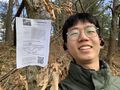
The poster and azsr
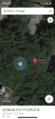
Ehh... close enough (?)
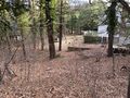
A flock of turkeys not too far from the geohash


Achievements
azsr earned the Public transport geohash achievement
|