2020-02-28 53 -1
| Fri 28 Feb 2020 in 53,-1: 53.4050773, -1.7840553 geohashing.info google osm bing/os kml crox |
Location
A clearing in the wood along Snake Pass.
Participants
- KarMann
- KarMann's wife
Plans
Find parking somewhere along Snake Road and walk a couple of hundred metres to the hashpoint.
Expedition
We set off (relatively) early in order to reach the hashpoint and still go for some others that day. The drive through the hills of the Peak District kept KarMann on his toes, which was a rather weird position in which to drive. Getting to the point where a driveway would maybe take us closer, we puzzled over the interpretation of the sign at the base. How would we get permission if we couldn't even get to the house to ask for it? We chose to take a broad interpretation of 'access', and proceeded to slowly, carefully, make our way up the driveway to the house at the end, hoping for a Ambassador achievement.
When we got there, though, there seemed to be no one home but the guardian dinosaurs and perhaps a dog. After taking a couple of pictures, we got back into the car, crept not-quite-so-slowly down the driveway, and got back onto the road for first some warm-up coffee, and then the trip to the Birmingham hashpoint.
Tracklog
Photos
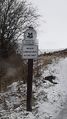
Our first warning sign, if somewhat ambiguous as to its interpretation.
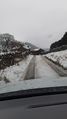
A steep, wet, and snowy climb to the residence nearest the hashpoint.
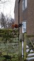
Another hashpoint guarded by dinosaurs.

Sad KarMann was sad upon realising we wouldn't be reaching this hashpoint today.


Achievements
KarMann & KarMann's wife earned the No trespassing consolation prize
|