Difference between revisions of "2020-02-29 48 11"
Clearlucid9 (talk | contribs) (→Participants) |
m |
||
| (13 intermediate revisions by 2 users not shown) | |||
| Line 21: | Line 21: | ||
== Plans == | == Plans == | ||
| − | + | I plan to walk there at about 3 p.m. | |
== Expedition == | == Expedition == | ||
| − | + | 29th of February - a day we get only once every 4 years! What a surprise when after breakfast I opened the app and found that today's hash was less than 2 km from home! Probably the closest hash to home I have ever been able to log (I think my first one was a bit more than 2 km from home...). | |
| + | The former military airfield had been converted into a landscape park (Landschaftsgarten) about 25 years ago, but the runway has been left in and is being used for cycling, walking and kite surfing on wheels as well as paragliding training area. As the weather turned out to be quite warm for this time of the year there were lots of people around. I had planed to draw the Geohashing logo on the runway, but once we were there I realised that I had forgotten the chalk at home :-( | ||
| + | The hash was just 50m from the runway and we managed to get within less than a meter. | ||
| + | Took the mandatory pictures and then we cycled back home. | ||
== Tracklog == | == Tracklog == | ||
| Line 34: | Line 37: | ||
--> | --> | ||
<gallery perrow="5"> | <gallery perrow="5"> | ||
| + | |||
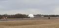
| + | Image:2020-02-29_48_11_Clearlucid9 _1582985940203.jpg|Aerial view | ||
| + | |||
| + | Image:2020-02-29_48_11_Clearlucid9 _1582985972896.jpg|Logproof | ||
| + | |||
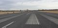
| + | Image:2020-02-29_48_11_Clearlucid9 _1582986057499.jpg|Runway looking east | ||
| + | |||
| + | Image:2020-02-29_48_11_Clearlucid9 _1582986085117.jpg|Runway looking west | ||
| + | |||
| + | Image:2020-02-29_48_11_Clearlucid9 _1582986129517.jpg|We at the hashpoint (upside down...) | ||
| + | |||
| + | Image:2020-02-29_48_11_Clearlucid9 _1582986168337.jpg|Panorama from the hash coirdinates | ||
| + | |||
| + | Image:2020-02-29_48_11_Clearlucid9 _1582986224930.jpg|Radar station of the military university | ||
| + | |||
| + | Image:2020-02-29_48_11_Clearlucid9 _1582986296673.jpg|Windsurfing and windkiting on the runway | ||
</gallery> | </gallery> | ||
| Line 39: | Line 58: | ||
{{#vardefine:ribbonwidth|800px}} | {{#vardefine:ribbonwidth|800px}} | ||
<!-- Add any achievement ribbons you earned below, or remove this section --> | <!-- Add any achievement ribbons you earned below, or remove this section --> | ||
| + | {{leap geohash|year=2020|lat=48|lon=11}} | ||
| − | + | {{bicycle geohash | latitude = 48 | longitude = 11 | date = 2020-02-29 | name = Clearlucid9 | distance = 1.8km | bothways = true}} | |
| − | |||
| − | |||
| − | |||
| − | |||
| − | |||
| − | |||
| − | |||
| − | |||
| − | |||
| − | |||
| − | |||
| − | |||
[[Category:Expeditions]] | [[Category:Expeditions]] | ||
| − | |||
[[Category:Expeditions with photos]] | [[Category:Expeditions with photos]] | ||
| − | |||
| − | |||
| − | |||
| − | |||
| − | |||
[[Category:Coordinates reached]] | [[Category:Coordinates reached]] | ||
| − | + | {{location|DE|BY|M}} | |
| − | |||
| − | |||
| − | |||
| − | |||
| − | |||
| − | |||
| − | |||
| − | |||
| − | |||
| − | |||
| − | |||
| − | |||
| − | |||
| − | |||
| − | |||
| − | |||
| − | |||
Latest revision as of 10:39, 24 September 2021
| Sat 29 Feb 2020 in 48,11: 48.0713524, 11.6336988 geohashing.info google osm bing/os kml crox |
Location
In a landscape park that used to be an army airfield just south east of Munich (Neubiberg/Unterhaching)
Participants
Plans
I plan to walk there at about 3 p.m.
Expedition
29th of February - a day we get only once every 4 years! What a surprise when after breakfast I opened the app and found that today's hash was less than 2 km from home! Probably the closest hash to home I have ever been able to log (I think my first one was a bit more than 2 km from home...). The former military airfield had been converted into a landscape park (Landschaftsgarten) about 25 years ago, but the runway has been left in and is being used for cycling, walking and kite surfing on wheels as well as paragliding training area. As the weather turned out to be quite warm for this time of the year there were lots of people around. I had planed to draw the Geohashing logo on the runway, but once we were there I realised that I had forgotten the chalk at home :-( The hash was just 50m from the runway and we managed to get within less than a meter. Took the mandatory pictures and then we cycled back home.
Tracklog
Photos
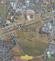
Aerial view
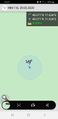
Logproof
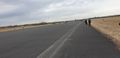
Runway looking east
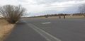
Runway looking west
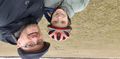
We at the hashpoint (upside down...)
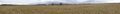
Panorama from the hash coirdinates
Radar station of the military university
Windsurfing and windkiting on the runway
Achievements

Clearlucid9 earned the Bicycle geohash achievement
|