Difference between revisions of "2020-02-29 52 -4"
m (add categories) |
m (per Renaming Proposal) |
||
| (18 intermediate revisions by 2 users not shown) | |||
| Line 12: | Line 12: | ||
| date=2020-02-29 | | date=2020-02-29 | ||
}}<!-- edit as necessary --> | }}<!-- edit as necessary --> | ||
| − | + | ||
== Location == | == Location == | ||
<!-- where you've surveyed the hash to be --> | <!-- where you've surveyed the hash to be --> | ||
| + | In a field near Cardigan/Ceredigion in Wales. | ||
== Participants == | == Participants == | ||
| − | [[User:KarMann|KarMann]] | + | * [[User:KarMann|KarMann]] |
| + | * KarMann's wife | ||
== Plans == | == Plans == | ||
<!-- what were the original plans --> | <!-- what were the original plans --> | ||
| + | Once the [[Leap geohash achievement|leap day]] coordinates were announced, we settled on a plan of driving out to southwest Wales, spending the night in Fishguard, and getting the as-of-yet-unhashed [[Aberystwyth, United Kingdom|Aberystwyth]] graticule, then trying a few more hashpoints along the way back to [[Manchester, United Kingdom|Manchester]]. We weren't sure about the nature of the field, but from the satellite view, it certainly seemed to have a good gate and track going into it, right toward the hashpoint. So we'd get an early start, drive to the road by the field, and check it out. | ||
== Expedition == | == Expedition == | ||
<!-- how it all turned out. your narrative goes here. --> | <!-- how it all turned out. your narrative goes here. --> | ||
| + | We got up, and, after a lovely breakfast, and some photography by the seaside, headed off to Cardigan for the hashpoint. There was lovely scenery along the way, and some ominous-looking weather and wet areas, but nothing too off-putting. After a fair wait at some of the one-lane temporary traffic lights, we approached the lane that apparently led to the field with our first destination of the day. | ||
| + | |||
| + | We found the gate we'd seen in the satellite views, although maybe a little more closed-up looking than we'd hoped. Nonetheless, our new [[hashscot]] Curdis remembered to accompany us properly this time, and get his photo taken. We worked our way around the gate, and made our way to the hashpoint, phone in hand to find just the right spot. | ||
| + | |||
| + | And, just as we got to that spot, we learned of our mistake. Apparently, this was not a public right-of-way or access field, and the presumable owner had seen our car and arrived to chase us off. I did take one quick screenshot of the geohashing app as we started back to the gate and the car, and we were feeling much chastised. We left promptly, and headed off to [[2020-02-29 52 -3|our next hashpoint for the day]], in [[Mid Wales, United Kingdom|Mid Wales]], and the exciting and interesting weather along the way. | ||
== Tracklog == | == Tracklog == | ||
<!-- if your GPS device keeps a log, you may post a link here --> | <!-- if your GPS device keeps a log, you may post a link here --> | ||
| + | [https://www.wikiloc.com/car-trails/2020-02-29-54-2-geohash-expedition-47416854 On WikiLoc] | ||
== Photos == | == Photos == | ||
| Line 33: | Line 42: | ||
--> | --> | ||
<gallery perrow="5"> | <gallery perrow="5"> | ||
| + | Image:2020-02-29 52 -4 Gate.jpg | [[User:KarMann|KarMann]] and [[hashscot]] Curdis at the gate to the field, hashpoint visible a short ways off. | ||
| + | Image:2020-02-29 52 -4 App map.png | The one screenshot we got before being chased off the field. | ||
</gallery> | </gallery> | ||
| Line 38: | Line 49: | ||
{{#vardefine:ribbonwidth|800px}} | {{#vardefine:ribbonwidth|800px}} | ||
<!-- Add any achievement ribbons you earned below, or remove this section --> | <!-- Add any achievement ribbons you earned below, or remove this section --> | ||
| + | {{land geohash | ||
| + | | latitude = 52 | ||
| + | | longitude = -4 | ||
| + | | date = 2020-02-29 | ||
| + | | name = [[User:KarMann|KarMann]] & Algernon | ||
| + | | image = 2020-02-29 52 -4 Gate.jpg | ||
| + | }} | ||
| + | {{Graticule unlocked | ||
| + | | latitude = 52 | ||
| + | | longitude = -4 | ||
| + | | date = 2020-02-29 | ||
| + | | name = [[User:KarMann|KarMann]] & Algernon | ||
| + | }} | ||
| + | {{Leap geohash | ||
| + | | year = 2020 | ||
| + | | lat = 52 | ||
| + | | lon = -4 | ||
| + | | name = [[User:KarMann|KarMann]] & Algernon | ||
| + | | image = 2020-02-29 52 -4 App map.png | ||
| + | }} | ||
| + | {{consecutive geohash 3 | ||
| + | | hashcount = 2 | ||
| + | | daycount = 2 | ||
| + | | latitude = 52 | ||
| + | | longitude = -1 | ||
| + | | date = 2020-02-28 | ||
| + | | name = [[User:KarMann|KarMann]] & Algernon | ||
| + | }} | ||
| − | <!-- =============== USEFUL CATEGORIES FOLLOW ================ | + | <!-- =============== USEFUL CATEGORIES FOLLOW ================ --> |
| − | |||
| − | |||
| − | |||
| − | |||
| − | |||
| − | |||
| − | |||
| − | |||
| − | |||
| − | |||
| − | |||
| − | |||
| − | |||
[[Category:Expeditions]] | [[Category:Expeditions]] | ||
| − | |||
| − | |||
[[Category:Expeditions with photos]] | [[Category:Expeditions with photos]] | ||
| − | |||
| − | |||
| − | |||
| − | |||
| − | |||
[[Category:Coordinates reached]] | [[Category:Coordinates reached]] | ||
| − | + | {{location|GB|CYM|CGN}} | |
| − | |||
| − | |||
| − | |||
| − | |||
| − | |||
| − | |||
| − | |||
| − | |||
| − | |||
| − | |||
| − | |||
| − | |||
| − | |||
| − | |||
| − | |||
| − | |||
| − | |||
Latest revision as of 04:49, 20 March 2024
| Sat 29 Feb 2020 in 52,-4: 52.0713524, -4.6336988 geohashing.info google osm bing/os kml crox |
Location
In a field near Cardigan/Ceredigion in Wales.
Participants
- KarMann
- KarMann's wife
Plans
Once the leap day coordinates were announced, we settled on a plan of driving out to southwest Wales, spending the night in Fishguard, and getting the as-of-yet-unhashed Aberystwyth graticule, then trying a few more hashpoints along the way back to Manchester. We weren't sure about the nature of the field, but from the satellite view, it certainly seemed to have a good gate and track going into it, right toward the hashpoint. So we'd get an early start, drive to the road by the field, and check it out.
Expedition
We got up, and, after a lovely breakfast, and some photography by the seaside, headed off to Cardigan for the hashpoint. There was lovely scenery along the way, and some ominous-looking weather and wet areas, but nothing too off-putting. After a fair wait at some of the one-lane temporary traffic lights, we approached the lane that apparently led to the field with our first destination of the day.
We found the gate we'd seen in the satellite views, although maybe a little more closed-up looking than we'd hoped. Nonetheless, our new hashscot Curdis remembered to accompany us properly this time, and get his photo taken. We worked our way around the gate, and made our way to the hashpoint, phone in hand to find just the right spot.
And, just as we got to that spot, we learned of our mistake. Apparently, this was not a public right-of-way or access field, and the presumable owner had seen our car and arrived to chase us off. I did take one quick screenshot of the geohashing app as we started back to the gate and the car, and we were feeling much chastised. We left promptly, and headed off to our next hashpoint for the day, in Mid Wales, and the exciting and interesting weather along the way.
Tracklog
Photos
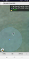
The one screenshot we got before being chased off the field.

Achievements
KarMann & Algernon earned the Land geohash achievement
|
KarMann & Algernon earned the Graticule Unlocked Achievement
|


KarMann & Algernon earned the Consecutive geohash achievement
|