Difference between revisions of "2020-02-29 55 11"
(→Photos) |
m (→Plans) |
||
| Line 33: | Line 33: | ||
I will probably have a little look around Vordingborg, and get some sandwiches and drinks to take with me on the bike ride. | I will probably have a little look around Vordingborg, and get some sandwiches and drinks to take with me on the bike ride. | ||
| + | |||
| + | [[File:Skærmbillede 2020-02-28 kl. 19.01.50.png|250px|thumb|left|Vordingborg to geohash]] | ||
At 14.00 i will set off on the bike ride and enjoy the long spit between Avnø Fjord and Smålandsfarvandet. Google Maps says it should take about an hour to cycle to as close the geohash as possible, but i'll allow plenty of time because i'm sure i'll want to stop and take lots of photos! | At 14.00 i will set off on the bike ride and enjoy the long spit between Avnø Fjord and Smålandsfarvandet. Google Maps says it should take about an hour to cycle to as close the geohash as possible, but i'll allow plenty of time because i'm sure i'll want to stop and take lots of photos! | ||
| − | |||
| − | |||
I will aim to be at the edge of the spit at around 16.00, as close as i can get to the geohash point without getting too wet! | I will aim to be at the edge of the spit at around 16.00, as close as i can get to the geohash point without getting too wet! | ||
| − | |||
| − | |||
== Expedition == | == Expedition == | ||
Revision as of 18:19, 1 March 2020
| Sat 29 Feb 2020 in Næstved, Denmark: 55.0713524, 11.6336988 geohashing.info google osm bing/os kml crox |
Contents
Location
Knudsskovvej, Vordingborg, Sjælland
Location Trivia
The name Knudsskovvej can be translated as Canute's Forest Path. This path seems to go the entire length of the spit.
Participants
Plans
Sermoa, inspired by Macronencer, who was inspired by KarMann, will try to get a Leap geohash achievement. Because it's a saturday, it's on Feb 29, and i'll have just got paid!
By the looks of it, i can get to within about 600 metres of the hash, which lands in the sea just south of Sjælland. But honestly, that spit looks like an utterly awesome place to explore anyway, leap geohash or not! My idea of starting geohashing again is to find reasons to explore more of Denmark, so yeah! Let the adventures commence!
Astonishingly, it seems as though this will also qualify as a Virgin Graticule achievement!
Detailed Plans

I like details!
I will take my bike on the 11.37 Regional-tog from Københavns Hovedbanegård, arriving at Vordingborg at 12.49.
I will probably have a little look around Vordingborg, and get some sandwiches and drinks to take with me on the bike ride.

At 14.00 i will set off on the bike ride and enjoy the long spit between Avnø Fjord and Smålandsfarvandet. Google Maps says it should take about an hour to cycle to as close the geohash as possible, but i'll allow plenty of time because i'm sure i'll want to stop and take lots of photos!
I will aim to be at the edge of the spit at around 16.00, as close as i can get to the geohash point without getting too wet!
Expedition
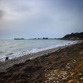
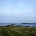
Photos
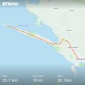
My Strava route
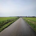
Along the Knudsskovvej
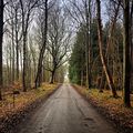
Through Knudsskov
A narrow causeway
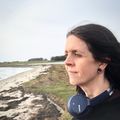
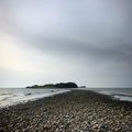
Made it roughly to the geohash
Very peaceful on the island
Fortunately i was able to get back
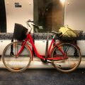
My bike on the train back


