Difference between revisions of "2020-03-01 51 -0"
From Geohashing
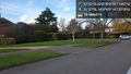
([live picture]Screenshot at the hashpoint. [https://openstreetmap.org/?lat=51.96530170&lon=-.23546160&zoom=16&layers=B000FTF @51.9653,-.2355]) |
(add categories) |
||
| Line 59: | Line 59: | ||
<!-- If all those plans are never acted upon, change [[Category:Expedition planning]] to [[Category:Not reached - Did not attempt]]. --> | <!-- If all those plans are never acted upon, change [[Category:Expedition planning]] to [[Category:Not reached - Did not attempt]]. --> | ||
| − | <!-- An actual expedition: | + | <!-- An actual expedition: --> |
[[Category:Expeditions]] | [[Category:Expeditions]] | ||
| − | -- and one or more of -- | + | <!-- and one or more of --> |
[[Category:Expeditions with photos]] | [[Category:Expeditions with photos]] | ||
| + | <!-- | ||
[[Category:Expeditions with videos]] | [[Category:Expeditions with videos]] | ||
[[Category:Expedition without GPS]] | [[Category:Expedition without GPS]] | ||
--> | --> | ||
| − | <!-- if you reached your coords: | + | <!-- if you reached your coords: --> |
[[Category:Coordinates reached]] | [[Category:Coordinates reached]] | ||
| − | + | <!-- | |
--><!-- or if you failed :( | --><!-- or if you failed :( | ||
[[Category:Coordinates not reached]] | [[Category:Coordinates not reached]] | ||
Revision as of 16:14, 1 March 2020
| Sun 1 Mar 2020 in 51,-0: 51.9654653, -0.2353182 geohashing.info google osm bing/os kml crox |
Location
Right on the pavement in a residential neighbourhood, so access won't be a problem here.
Participants
Plans
KarMann is going to hit the road and try to be there for the 16:00 meetup, after about a four hour drive.
Expedition
Tracklog
Photos
The hashpoint seen from the car. @51.9653,-.2354

At the hashpoint with Curdis & the car. @51.9655,-.2352

Screenshot at the hashpoint. @51.9653,-.2355


Achievements