Difference between revisions of "2020-03-12 52 8"
(Created page with "{{meetup graticule |lat = 52 |lon = 8 |date = 2020-03-12 |graticule_name = Bielefeld |graticule_link = 52,8 }} ==Location== The Geohash lays next to a ranch between wikipedi...") |
m |
||
| (One intermediate revision by one other user not shown) | |||
| Line 41: | Line 41: | ||
| name = *[[User:MrRoboticEvil | MrRoboticEvil]] | | name = *[[User:MrRoboticEvil | MrRoboticEvil]] | ||
}} | }} | ||
| + | [[Category:Expeditions]] | ||
| + | [[Category:Expeditions with photos]] | ||
| + | [[Category:Coordinates reached]] | ||
| + | {{location|DE|NW|HF}} | ||
Latest revision as of 08:53, 17 April 2020
| Thu 12 Mar 2020 in Bielefeld: 52.1402796, 8.8182208 geohashing.info google osm bing/os kml crox |
Location
The Geohash lays next to a ranch between Vlotho and Exter.
Participants
Expedition
This one was pretty easy for me as I live in Vlotho. I just got on my bike and cycled about 7km to the Hashpoint. I had to walk the last hundred metres, since the Path turned out to be really soaked due to the rain the night/week before. The Hashpoint was close to a small pond and I could see somebody riding on the ranch (although she didn't seem to notice me). On the way back home I made a detour and ended up cycling 30km for this expedition.
I guess you probably miss photos of the pond, the girl riding, the (not that spectacular) mud and the cool bird, I saw on my way back home. The truth is I just forgot to make them. Will do better next time!
Photos
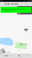
Yeah I even forgot to switch to the details screen
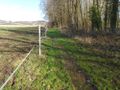
The hashpoint should be in this photo
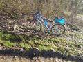
The hashcycle


Achievements
|
|