Difference between revisions of "2020-03-24 60 25"
(Created page with "{{meetup graticule | lat=60 | lon=25 | date=2020-03-24 }} __NOTOC__ == Location == In the pavement / cycling lane near the Opera house at Mannerheimintie Töölö == Plans...") |
|||
| (23 intermediate revisions by 3 users not shown) | |||
| Line 4: | Line 4: | ||
| date=2020-03-24 | | date=2020-03-24 | ||
}} | }} | ||
| + | __NOTOC__ | ||
| + | |||
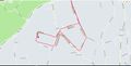
| + | [[File:2020-03-24_60-25_location.jpg]] | ||
| − | |||
== Location == | == Location == | ||
| + | Near of the Rudolfinpuisto Yliskylä Laajasalo Helsinki | ||
| − | + | == Plans == | |
| + | Got XKCD Coordinate Notify mail from NWoodruff's service <sup><small>(thanks)</small></sup> that said, tomorrow | ||
| + | the [[Vantaa,_Finland|N60 E25]] will be in the near proximity of my current quarantined office. I'll squeeze this on my schedule around midday [[User:PPP|PPP]] | ||
| − | + | Weather Should be fine for March: Cold, Windy but sunny | |
| − | |||
== Participants == | == Participants == | ||
| − | + | [[User:PPP|PPP]] | |
== Expedition == | == Expedition == | ||
| − | + | Very straight forward expedition, which I started at 11:14. The target area was reached at 11:24 just by instinct without any GPS aiding. When checked from geohash droid I was less than two meters off from the hashpoint in the small rock face. Total time of expedition 21m14sec travelled distance 3.3km by kickbike [[User:PPP|PPP]] | |
== Weather & Sky == | == Weather & Sky == | ||
| + | EFHK 240950Z 23018KT 9999 FEW025 07/M02 Q1028 NOSIG | ||
== Photos == | == Photos == | ||
| Line 27: | Line 32: | ||
<gallery> | <gallery> | ||
| − | + | Image:2020-03-24 60 25 track.jpg | The track or actually small part of it | |
| − | + | Image:2020-03-24_60_25_view_to.jpg | A view to location | |
| + | Image:2020-0324_60_25_the_hashpoint.JPG | Here it was in the Rock face. See my kickbike also! | ||
| + | Image:2020-0324-60_25_112417_Screenshot.png | The proof | ||
</gallery> | </gallery> | ||
[[Category:Expeditions]] | [[Category:Expeditions]] | ||
| + | [[Category:Coordinates reached]] | ||
[[Category:Expeditions with photos]] | [[Category:Expeditions with photos]] | ||
| − | [[Category: | + | [[Category:Expedition without GPS]] |
{{location|FI|18}} | {{location|FI|18}} | ||
| − | |||
Latest revision as of 09:25, 7 September 2021
| Tue 24 Mar 2020 in 60,25: 60.1717601, 25.0361746 geohashing.info google osm bing/os kml crox |

Location
Near of the Rudolfinpuisto Yliskylä Laajasalo Helsinki
Plans
Got XKCD Coordinate Notify mail from NWoodruff's service (thanks) that said, tomorrow the N60 E25 will be in the near proximity of my current quarantined office. I'll squeeze this on my schedule around midday PPP
Weather Should be fine for March: Cold, Windy but sunny
Participants
Expedition
Very straight forward expedition, which I started at 11:14. The target area was reached at 11:24 just by instinct without any GPS aiding. When checked from geohash droid I was less than two meters off from the hashpoint in the small rock face. Total time of expedition 21m14sec travelled distance 3.3km by kickbike PPP
Weather & Sky
EFHK 240950Z 23018KT 9999 FEW025 07/M02 Q1028 NOSIG
Photos
The track or actually small part of it
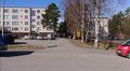
A view to location
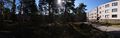
Here it was in the Rock face. See my kickbike also!
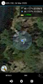
The proof


