Difference between revisions of "2020-03-30 52 13"
From Geohashing
([retro picture]The construction [https://openstreetmap.org/?lat=52.64863070&lon=13.45073920&zoom=16&layers=B000FTF @52.6486,13.4507]) |
m |
||
| (3 intermediate revisions by 2 users not shown) | |||
| Line 1: | Line 1: | ||
| − | + | {{meetup graticule | |
| − | |||
| − | |||
| − | |||
| − | |||
| − | |||
| − | |||
| − | |||
| − | |||
| lat=52 | | lat=52 | ||
| lon=13 | | lon=13 | ||
| date=2020-03-30 | | date=2020-03-30 | ||
| − | }} | + | | retro=1 |
| + | }} | ||
__NOTOC__ | __NOTOC__ | ||
== Location == | == Location == | ||
| Line 17: | Line 10: | ||
== Participants == | == Participants == | ||
| − | + | *[[User:CamelCase|CamelCase]] ([[User talk:CamelCase|talk]]) | |
| − | |||
| − | [[User:CamelCase|CamelCase]] ([[User talk:CamelCase|talk]]) | ||
== Plans == | == Plans == | ||
| Line 25: | Line 16: | ||
== Expedition == | == Expedition == | ||
| − | |||
| − | |||
| − | |||
*This is a test. -- [[User:CamelCase|CamelCase]] ([[User talk:CamelCase|talk]]) 00:11, 30 March 2020 (GMT+02:00) | *This is a test. -- [[User:CamelCase|CamelCase]] ([[User talk:CamelCase|talk]]) 00:11, 30 March 2020 (GMT+02:00) | ||
*Got as close as I will. A day late, but who cares. -- [[User:CamelCase|CamelCase]] ([[User talk:CamelCase|talk]]) [https://openstreetmap.org/?lat=52.64863460&lon=13.45074030&zoom=16&layers=B000FTF @52.6486,13.4507] 13:49, 31 March 2020 (GMT+02:00) | *Got as close as I will. A day late, but who cares. -- [[User:CamelCase|CamelCase]] ([[User talk:CamelCase|talk]]) [https://openstreetmap.org/?lat=52.64863460&lon=13.45074030&zoom=16&layers=B000FTF @52.6486,13.4507] 13:49, 31 March 2020 (GMT+02:00) | ||
| − | |||
| − | |||
== Photos == | == Photos == | ||
| − | |||
| − | |||
| − | |||
<gallery perrow="5"> | <gallery perrow="5"> | ||
| Line 51: | Line 34: | ||
<!-- Add any achievement ribbons you earned below, or remove this section --> | <!-- Add any achievement ribbons you earned below, or remove this section --> | ||
| − | + | [[Category:Retro meetup]] | |
| − | |||
| − | [[Category: | ||
| − | |||
| − | |||
| − | |||
| − | |||
| − | |||
| − | |||
| − | |||
| − | |||
| − | |||
| − | |||
| − | |||
| − | |||
| − | |||
[[Category:Expeditions with photos]] | [[Category:Expeditions with photos]] | ||
| − | [[Category: | + | [[Category:Retro coordinates not reached]] |
| − | |||
| − | |||
| − | |||
| − | |||
| − | |||
| − | |||
| − | |||
| − | |||
| − | |||
| − | |||
| − | |||
| − | |||
| − | |||
| − | |||
[[Category:Not reached - No public access]] | [[Category:Not reached - No public access]] | ||
| − | + | {{location|DE|BB|BAR}} | |
| − | |||
| − | |||
| − | |||
| − | |||
| − | |||
| − | |||
| − | |||
Latest revision as of 18:54, 11 September 2021
| Mon 30 Mar 2020 in 52,13: 52.6464745, 13.4386037 geohashing.info google osm bing/os kml crox |
Location
Just outside the northern city border. Since leaving the city is one of the valid reasons for leaving your house during the current lockdown, this expedition should be legal under Berlin state law (as long as there's no more than two of us, we keep 1.5m distance, carry ID, etc). Don't know about Brandenburg state though.
Participants
Plans
CamelCase plans to walk the 18km from the city centre.
Expedition
- Got as close as I will. A day late, but who cares. -- CamelCase (talk) @52.6486,13.4507 13:49, 31 March 2020 (GMT+02:00)
Photos
Proof @52.6486,13.4508
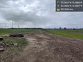
The hash is under those wires. @52.6486,13.4508
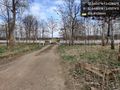
The construction @52.6486,13.4507


