Difference between revisions of "2020-04-15 -37 144"
Felix Dance (talk | contribs) (Created page with "{{meetup graticule | lat=-37 | lon=144 | date=2020-04-15 }} __NOTOC__ == Location == Between two farms near Gisbourne. == Participants == *Felix Dance...") |
Felix Dance (talk | contribs) (Added expedition description) |
||
| Line 1: | Line 1: | ||
| + | [[Image:{{{IMAGE|Geohash 2020-04-15 -37 144 02 Felix.jpg}}}|thumb|left]] | ||
| + | |||
{{meetup graticule | {{meetup graticule | ||
| lat=-37 | | lat=-37 | ||
| Line 14: | Line 16: | ||
== Expedition == | == Expedition == | ||
| + | Today I got up planning to go on a fairly long bike ride to the north of Melbourne, getting some exercise in during the quarantine. But, of course, when I checked the hash in the morning I saw that there was an equally good ride to be had that also included a geohash. | ||
| + | I set off on my dilapidated road bike up along some new-found bike tracks in Melbourne's west, finally being spat out onto the Calder Freeway to ride hash-wards, into the headwind. | ||
| + | |||
| + | It wasn't long before my knees started paining as I'd overdone the exertion in my eagerness to reach the hash - but luckily, a quick fence or two, and I was at the road's closest approach. | ||
| + | |||
| + | From the satellite view it'd looked like the hash lay on a small, dirt road between two farms but on inspection the road was just a windbreak. I disbiked and clambered along the tree-line up the hill, my route threading between the fences of each property. | ||
| + | |||
| + | After 500m I arrived. I took a moment to soak in the view of the distant Melbourne skyline and eat some lunch before heading back down the slope to my bike. I continued north-west to Gisbourne Peak for some research into a future long ride, before circling back a slightly different route and another city-radiating bike path. | ||
== Photos == | == Photos == | ||
| − | + | <gallery> | |
| + | File:Geohash 2020-04-15 -37 144 01 City.jpg|City skyline | ||
| + | File:Geohash 2020-04-15 -37 144 02 Felix.jpg|Hashface | ||
| + | File:Geohash 2020-04-15 -37 144 03 View.jpg|View from the hash | ||
| + | File:Geohash 2020-04-15 -37 144 04 Panorama.jpg|Panorama | ||
| + | File:Geohash 2020-04-15 -37 144 05 GPS Proof.jpg|GPS Proof | ||
| + | File:Geohash 2020-04-15 -37 144 06 Strava.jpg|Strava route | ||
| + | </gallery> | ||
== Achievements == | == Achievements == | ||
| Line 28: | Line 45: | ||
| distance = 118kms | | distance = 118kms | ||
| bothways = true | | bothways = true | ||
| − | | image = | + | | image = Geohash 2020-04-15 -37 144 02 Felix.jpg |
}} | }} | ||
Revision as of 11:32, 16 April 2020

| Wed 15 Apr 2020 in -37,144: -37.5812129, 144.6742602 geohashing.info google osm bing/os kml crox |
Location
Between two farms near Gisbourne.
Participants
Expedition
Today I got up planning to go on a fairly long bike ride to the north of Melbourne, getting some exercise in during the quarantine. But, of course, when I checked the hash in the morning I saw that there was an equally good ride to be had that also included a geohash.
I set off on my dilapidated road bike up along some new-found bike tracks in Melbourne's west, finally being spat out onto the Calder Freeway to ride hash-wards, into the headwind.
It wasn't long before my knees started paining as I'd overdone the exertion in my eagerness to reach the hash - but luckily, a quick fence or two, and I was at the road's closest approach.
From the satellite view it'd looked like the hash lay on a small, dirt road between two farms but on inspection the road was just a windbreak. I disbiked and clambered along the tree-line up the hill, my route threading between the fences of each property.
After 500m I arrived. I took a moment to soak in the view of the distant Melbourne skyline and eat some lunch before heading back down the slope to my bike. I continued north-west to Gisbourne Peak for some research into a future long ride, before circling back a slightly different route and another city-radiating bike path.
Photos
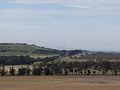
City skyline
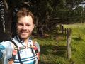
Hashface
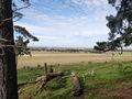
View from the hash
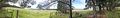
Panorama
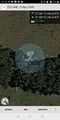
GPS Proof
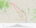
Strava route


Achievements
Felix Dance earned the Bicycle geohash achievement
|