Difference between revisions of "2020-04-26 39 -76"
From Geohashing
([live] The wiki isn't updating for some reason so I'm sending another test message) |
|||
| (7 intermediate revisions by one other user not shown) | |||
| Line 1: | Line 1: | ||
| − | + | {{meetup graticule | |
| − | |||
| − | |||
| − | |||
| − | |||
| − | |||
| − | |||
| − | |||
| − | |||
| lat=39 | | lat=39 | ||
| lon=-76 | | lon=-76 | ||
| date=2020-04-26 | | date=2020-04-26 | ||
| − | }} | + | }} |
__NOTOC__ | __NOTOC__ | ||
== Location == | == Location == | ||
| − | + | This Geohash is located in a forest west of Cardiff just south of the Maryland-Pennsylvania border. | |
== Participants == | == Participants == | ||
| − | + | *[[User:OfficeLinebacker|OfficeLinebacker]] | |
| − | |||
| − | == | + | == Expedition == |
| − | + | *The wiki isn't updating for some reason so I'm sending another test message -- [[User:OfficeLinebacker|OfficeLinebacker]] ([[User talk:OfficeLinebacker|talk]]) [https://openstreetmap.org/?lat=39.19963350&lon=-76.76255480&zoom=16&layers=B000FTF @39.1996,-76.7626] 09:49, 26 April 2020 (EDT) | |
| − | + | *P another text message without location of him -- [[User:OfficeLinebacker|OfficeLinebacker]] ([[User talk:OfficeLinebacker|talk]]) 09:49, 26 April 2020 (EDT) | |
| − | |||
| + | *So there was some kind of problem with the GH4 Droid app before Oh, So my previous updates have gone missing. I am attempting this one because it doesn't appear to be a long walk outside of the car, even though it is in the woods. It's raining today so assuming that it is a downpour, I will still attempt it it just get wet -- [[User:OfficeLinebacker|OfficeLinebacker]] ([[User talk:OfficeLinebacker|talk]]) [https://openstreetmap.org/?lat=39.21006560&lon=-76.74179340&zoom=16&layers=B000FTF @39.2101,-76.7418] 09:50, 26 April 2020 (EDT) | ||
| − | * | + | *I am in Pennsylvania now, and I will have to cross over into Maryland in order to achieve the objective -- [[User:OfficeLinebacker|OfficeLinebacker]] ([[User talk:OfficeLinebacker|talk]]) [https://openstreetmap.org/?lat=39.72161180&lon=-76.31779640&zoom=16&layers=B000FTF @39.7216,-76.3178] 11:00, 26 April 2020 (EDT) |
| − | |||
| − | |||
== Photos == | == Photos == | ||
| − | |||
| − | |||
| − | |||
<gallery perrow="5"> | <gallery perrow="5"> | ||
| + | |||
| + | Image:2020-04-26_39_-76_OfficeLinebacker_1587909552011.jpg|Bal'imore [https://openstreetmap.org/?lat=39.26908860&lon=-76.63261900&zoom=16&layers=B000FTF @39.2691,-76.6326] | ||
| + | |||
| + | Image:2020-04-26_39_-76_OfficeLinebacker_1587912611763.jpg|I suppose that you could call this a sign of the times [https://openstreetmap.org/?lat=39.71711220&lon=-76.29779600&zoom=16&layers=B000FTF @39.7171,-76.2978] | ||
| + | |||
| + | Image:2020-04-26_39_-76_OfficeLinebacker_1587913221527.jpg|Just a drizzle, and the on foot journey begins here, with 440 ft to go [https://openstreetmap.org/?lat=39.72165510&lon=-76.31779710&zoom=16&layers=B000FTF @39.7217,-76.3178] | ||
| + | |||
| + | Image:2020-04-26_39_-76_OfficeLinebacker_1587913531986.jpg|Made it! [https://openstreetmap.org/?lat=39.72097390&lon=-76.31712180&zoom=16&layers=B000FTF @39.7210,-76.3171] | ||
</gallery> | </gallery> | ||
| Line 42: | Line 36: | ||
<!-- Add any achievement ribbons you earned below, or remove this section --> | <!-- Add any achievement ribbons you earned below, or remove this section --> | ||
| − | |||
| − | |||
| − | |||
| − | |||
| − | |||
| − | |||
| − | |||
| − | |||
| − | |||
| − | |||
| − | |||
| − | |||
| − | |||
| − | |||
[[Category:Expeditions]] | [[Category:Expeditions]] | ||
| − | |||
[[Category:Expeditions with photos]] | [[Category:Expeditions with photos]] | ||
| − | |||
| − | |||
| − | |||
| − | |||
| − | |||
[[Category:Coordinates reached]] | [[Category:Coordinates reached]] | ||
| − | + | {{location|US|MD|HA}} | |
| − | |||
| − | |||
| − | |||
| − | |||
| − | |||
| − | |||
| − | |||
| − | |||
| − | |||
| − | |||
| − | |||
| − | |||
| − | |||
| − | |||
| − | |||
| − | |||
| − | |||
Latest revision as of 19:00, 1 May 2020
| Sun 26 Apr 2020 in 39,-76: 39.7209063, -76.3172133 geohashing.info google osm bing/os kml crox |
Location
This Geohash is located in a forest west of Cardiff just south of the Maryland-Pennsylvania border.
Participants
Expedition
- The wiki isn't updating for some reason so I'm sending another test message -- OfficeLinebacker (talk) @39.1996,-76.7626 09:49, 26 April 2020 (EDT)
- P another text message without location of him -- OfficeLinebacker (talk) 09:49, 26 April 2020 (EDT)
- So there was some kind of problem with the GH4 Droid app before Oh, So my previous updates have gone missing. I am attempting this one because it doesn't appear to be a long walk outside of the car, even though it is in the woods. It's raining today so assuming that it is a downpour, I will still attempt it it just get wet -- OfficeLinebacker (talk) @39.2101,-76.7418 09:50, 26 April 2020 (EDT)
- I am in Pennsylvania now, and I will have to cross over into Maryland in order to achieve the objective -- OfficeLinebacker (talk) @39.7216,-76.3178 11:00, 26 April 2020 (EDT)
Photos

Bal'imore @39.2691,-76.6326
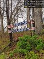
I suppose that you could call this a sign of the times @39.7171,-76.2978
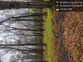
Just a drizzle, and the on foot journey begins here, with 440 ft to go @39.7217,-76.3178

Made it! @39.7210,-76.3171


