Difference between revisions of "2020-05-10 61 29"
(Created page with "{{subst:Expedition |lat = 61 |lon = 29 |date = 2020-05-10 }}") |
m |
||
| (3 intermediate revisions by 2 users not shown) | |||
| Line 1: | Line 1: | ||
| − | + | {{meetup graticule | |
| − | |||
| − | |||
| − | |||
| − | |||
| − | |||
| − | |||
| − | |||
| − | |||
| lat=61 | | lat=61 | ||
| lon=29 | | lon=29 | ||
| date=2020-05-10 | | date=2020-05-10 | ||
| − | }} | + | }} |
__NOTOC__ | __NOTOC__ | ||
== Location == | == Location == | ||
| − | + | In a forest, rather easily accessible and probably swarming with mosquitoes. | |
== Participants == | == Participants == | ||
| − | + | *[[User:Kripakko|Kripakko]] | |
| − | + | *Kripakko's father | |
== Plans == | == Plans == | ||
| − | + | I will visit South Karelia with my father, and visiting this hashpoint will not require a huge detour. It should be easily accessible especially if we can drive along the trail that leads to a former logging area. Even if we cannot, we can walk the half-kilometre distance from the big road. | |
| + | |||
| + | This, along with [[2020-05-10 62 29]], will be a [[Multihash|Double Hash]] if we can reach both. And we definitely can unless we run out of time for some reason or something catastrophic happens. | ||
== Expedition == | == Expedition == | ||
| − | + | After visiting [[2020-05-10 62 29]] and later our relatives in South Karelia, we came here before heading for Joensuu again. This hashpoint was more interesting than the previous one. | |
| − | + | We arrived at the intersection where the trail branched off the road. It was indeed drivable by car, though not for the faint-hearted or for those with off-road incapable cars. There were bumps, potholes, rocks, loose tree branches and little saplings on the trail, but we could manage with all of them until we were stopped by a fallen tree. That would not move easily and we did not want to drive over it. We were almost as close to the hashpoint as we could get to by car anyway, so we continued on foot. | |
| − | + | ||
| + | After walking some 75 metres through the forest we arrived at the hashpoint. It was located in a beautiful spruce forest with little underbrush. The forest was dense enough that spruce tops blocked almost all direct sunlight, and so it was rather dim even in the middle of the day. We took a few pictures for proof and left soon thereafter. We still had a long drive ahead of us. | ||
== Photos == | == Photos == | ||
| − | < | + | <gallery perrow="6"> |
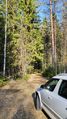
| − | Image:2020- | + | Image:2020-05-10_61_29_01-trail.jpg | This was the trail that we had to drive along. 510 metres to go. |
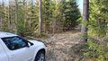
| − | -- | + | Image:2020-05-10_61_29_02-roadblock.jpg | We had to stop here because the fallen tree blocked the trail. 75 metres to go. |
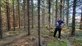
| − | + | Image:2020-05-10_61_29_03-forest.jpg | The hashpoint was in this spruce forest. | |
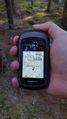
| + | Image:2020-05-10_61_29_04-gpsr.jpg | Hashpoint reached! | ||
| + | Image:2020-05-10_61_29_05-road.jpg | Rather typical Finnish gravel road. Feels much like My Summer Car in real life. | ||
| + | Image:2020-05-10_61_29_06-mosquito.jpg | There were thankfully few mosquitoes, here is one of them. | ||
</gallery> | </gallery> | ||
== Achievements == | == Achievements == | ||
{{#vardefine:ribbonwidth|800px}} | {{#vardefine:ribbonwidth|800px}} | ||
| − | + | {{land geohash | latitude = 61 | longitude = 29 | date = 2020-05-10 | name = Kripakko}} | |
| − | + | {{Multihash | latitude1 = 61 | longitude1 = 29 | latitude2 = 62 | longitude2 = 29 | date = 2020-05-10 | name = Kripakko}} | |
| − | + | {{Minesweeper geohash | graticule = Joensuu, Finland | ranknumber = 3 | n = true | e = true | s = true | name = Kripakko}} | |
| − | |||
| − | |||
| − | |||
| − | |||
| − | |||
| − | |||
| − | |||
| − | |||
| − | |||
| − | |||
| − | |||
| − | |||
[[Category:Expeditions]] | [[Category:Expeditions]] | ||
| − | |||
[[Category:Expeditions with photos]] | [[Category:Expeditions with photos]] | ||
| − | |||
| − | |||
| − | |||
| − | |||
| − | |||
[[Category:Coordinates reached]] | [[Category:Coordinates reached]] | ||
| − | + | {{location|FI|02}} | |
| − | |||
| − | |||
| − | |||
| − | |||
| − | |||
| − | |||
| − | |||
| − | |||
| − | |||
| − | |||
| − | |||
| − | |||
| − | |||
| − | |||
| − | |||
| − | |||
Latest revision as of 08:31, 13 May 2020
| Sun 10 May 2020 in 61,29: 61.7133386, 29.8297909 geohashing.info google osm bing/os kml crox |
Location
In a forest, rather easily accessible and probably swarming with mosquitoes.
Participants
- Kripakko
- Kripakko's father
Plans
I will visit South Karelia with my father, and visiting this hashpoint will not require a huge detour. It should be easily accessible especially if we can drive along the trail that leads to a former logging area. Even if we cannot, we can walk the half-kilometre distance from the big road.
This, along with 2020-05-10 62 29, will be a Double Hash if we can reach both. And we definitely can unless we run out of time for some reason or something catastrophic happens.
Expedition
After visiting 2020-05-10 62 29 and later our relatives in South Karelia, we came here before heading for Joensuu again. This hashpoint was more interesting than the previous one.
We arrived at the intersection where the trail branched off the road. It was indeed drivable by car, though not for the faint-hearted or for those with off-road incapable cars. There were bumps, potholes, rocks, loose tree branches and little saplings on the trail, but we could manage with all of them until we were stopped by a fallen tree. That would not move easily and we did not want to drive over it. We were almost as close to the hashpoint as we could get to by car anyway, so we continued on foot.
After walking some 75 metres through the forest we arrived at the hashpoint. It was located in a beautiful spruce forest with little underbrush. The forest was dense enough that spruce tops blocked almost all direct sunlight, and so it was rather dim even in the middle of the day. We took a few pictures for proof and left soon thereafter. We still had a long drive ahead of us.
Photos
This was the trail that we had to drive along. 510 metres to go.
We had to stop here because the fallen tree blocked the trail. 75 metres to go.
The hashpoint was in this spruce forest.
Hashpoint reached!
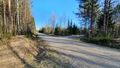
Rather typical Finnish gravel road. Feels much like My Summer Car in real life.
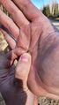
There were thankfully few mosquitoes, here is one of them.


Achievements
Kripakko earned the Land geohash achievement
|
Kripakko earned the Multihash Achievement
|
Kripakko achieved level 3 of the Minesweeper Geohash achievement
|