Difference between revisions of "2020-05-15 62 29"
(Created page with "{{subst:Expedition |lat = 62 |lon = 29 |date = 2020-05-15 }}") |
|||
| Line 1: | Line 1: | ||
| − | + | {{meetup graticule | |
| − | |||
| − | |||
| − | |||
| − | |||
| − | |||
| − | |||
| − | |||
| − | |||
| lat=62 | | lat=62 | ||
| lon=29 | | lon=29 | ||
| date=2020-05-15 | | date=2020-05-15 | ||
| − | }} | + | }} |
__NOTOC__ | __NOTOC__ | ||
== Location == | == Location == | ||
| − | + | At the edge of a field in the outskirts of Polvijärvi. | |
== Participants == | == Participants == | ||
| − | + | *[[User:Kripakko|Kripakko]] | |
| − | |||
== Plans == | == Plans == | ||
| − | + | The hashpoint is located 60 metres from the road. It should be simple to cycle there and back, and I can quite conveniently plan a circle route via Sotkuma and Käsämä to get the [[Tron achievement]]. | |
== Expedition == | == Expedition == | ||
| − | + | When I set out towards the hashpoint, the weather was warm (maybe 8–10 °C) and partly cloudy. There had been a strong hail shower about an hour before, but it had all dried out by then. There was a high chance of more showers during the day, so I packed warm clothes in a backpack in case it would rain much or get cold. I grabbed my mountain bike this time and started the 60+-kilometre journey. | |
| − | + | After about 15 minutes of riding, I saw large grey clouds approaching from the west and slowly covering the sky. They were undoubtedly rain clouds, but thankfully they missed me. The northern sky was nearly clear, the southern sky was dauntingly grey, and I could see the edge of the cloud on top of me. After a while the sun was shining again. | |
| − | + | ||
| + | At the edge of the airport I ran into strong headwind and a short hail shower that I did not avoid this time. Whereas my speed on level road was usually above 20 km/h, riding against headwind on this pebbly gravel road I could not possibly go above 15 km/h, and I felt so tired when the road entered the forest again. Afterwards the wind was never a problem, and I got two or three more hail showers. I did not take pictures of the hail because it always melted very quickly, but you can imagine tiny pinhead-sized balls of snow that stuck on every possible surface. | ||
| + | |||
| + | Close to the hashpoint, I noticed that the strip of forest had been felled a few years ago. There were lots of new saplings growing in it, but it was easy enough to traverse. I could walk with the bicycle and carry it all the way to the hashpoint. After documenting the visit, I walked back to the road again and carried on cycling. I still had more than 30 kilometres of road distance to cycle. Total distance was 67.7 kilometres. | ||
| + | |||
| + | I did indeed do a closed non-intersecting loop with the bicycle, required for the [[Tron achievement]]. However, I crossed my own track a couple of times on foot when I parked the bicycle and went to take pictures. This was not necessary to do, but better pictures make a better expedition report, so I think that I should not be disqualified because of these little side tracks. These are not visible in the GPS track because I kept the GPS receiver attached to the bicycle all the time. | ||
== Photos == | == Photos == | ||
| − | |||
| − | |||
| − | |||
<gallery perrow="5"> | <gallery perrow="5"> | ||
| + | Image:2020-05-16_62_29_01-clouds1.jpg | Rain clouds are coming and will soon obscure the sun. | ||
| + | Image:2020-05-16_62_29_02-clouds2.jpg | The huge rain cloud dominates the southern sky and barely misses me. | ||
| + | Image:2020-05-16_62_29_03-lake1.jpg | Pitkäsenlahti bay of Viinijärvi lake. | ||
| + | Image:2020-05-16_62_29_04-junction.jpg | Road junction in Sotkuma. | ||
| + | Image:2020-05-16_62_29_05-roadsign.jpg | I did not enjoy seeing this sign... "Pavement damage for the next 13 km." | ||
| + | Image:2020-05-16_62_29_06-hashpoint.jpg | Bicycle parked at the hashpoint. | ||
| + | Image:2020-05-16_62_29_07-gpsr.jpg | Hashpoint reached! | ||
| + | Image:2020-05-16_62_29_08-selfie.jpg | Me at the hashpoint. | ||
| + | Image:2020-05-16_62_29_09-field.jpg | The field next to the hashpoint. The bicycle is visible at the bottom. | ||
| + | Image:2020-05-16_62_29_10-forest.jpg | This is how the forest looks like now. Seems bad, but it was easy to walk through. | ||
| + | Image:2020-05-16_62_29_11-lake2.jpg | Käsämänsalmi strait of Viinijärvi lake, photographed on a bridge. | ||
| + | Image:2020-05-16_62_29_12-lake3.jpg | Same, other direction. | ||
| + | Image:2020-05-16_62_29_13-map.png | My tracklog (purple line) plotted on a topographic map. | ||
</gallery> | </gallery> | ||
| + | |||
| + | ''Hmm, I apparently misnamed all the images. The dates in the filenames are 2020-05-16 instead of 2020-05-15. But it should not matter at all since there was never a [[2020-05-16 62 29]] expedition (the hashpoint is in a lake and would require a boat or swimming over 800 metres in cold water).'' | ||
== Achievements == | == Achievements == | ||
{{#vardefine:ribbonwidth|800px}} | {{#vardefine:ribbonwidth|800px}} | ||
| − | |||
| − | |||
| − | |||
| − | |||
| − | |||
| − | |||
| − | |||
| − | |||
| − | |||
| − | |||
| − | |||
| − | |||
| − | + | {{land geohash | latitude = 62 | longitude = 29 | date = 2020-05-15 | name = Kripakko}} | |
| + | {{bicycle geohash | latitude = 62 | longitude = 29 | date = 2020-05-15 | name = Kripakko | distance = 67.7 km | bothways = true}} | ||
| + | {{Tron | latitude = 62 | longitude = 29 | date = 2020-05-15 | tracklog = https://geohashing.site/geohashing/File:2020-05-16_62_29_13-map.png | possessive = his | name = Kripakko}} | ||
| − | |||
[[Category:Expeditions]] | [[Category:Expeditions]] | ||
| − | |||
[[Category:Expeditions with photos]] | [[Category:Expeditions with photos]] | ||
| − | |||
| − | |||
| − | |||
| − | |||
| − | |||
[[Category:Coordinates reached]] | [[Category:Coordinates reached]] | ||
| − | |||
| − | |||
| − | |||
| − | |||
| − | |||
| − | |||
| − | |||
| − | |||
| − | |||
| − | |||
| − | |||
| − | |||
| − | |||
| − | |||
| − | |||
| − | |||
| − | |||
| − | |||
Revision as of 21:40, 16 May 2020
| Fri 15 May 2020 in 62,29: 62.6966825, 29.3829854 geohashing.info google osm bing/os kml crox |
Location
At the edge of a field in the outskirts of Polvijärvi.
Participants
Plans
The hashpoint is located 60 metres from the road. It should be simple to cycle there and back, and I can quite conveniently plan a circle route via Sotkuma and Käsämä to get the Tron achievement.
Expedition
When I set out towards the hashpoint, the weather was warm (maybe 8–10 °C) and partly cloudy. There had been a strong hail shower about an hour before, but it had all dried out by then. There was a high chance of more showers during the day, so I packed warm clothes in a backpack in case it would rain much or get cold. I grabbed my mountain bike this time and started the 60+-kilometre journey.
After about 15 minutes of riding, I saw large grey clouds approaching from the west and slowly covering the sky. They were undoubtedly rain clouds, but thankfully they missed me. The northern sky was nearly clear, the southern sky was dauntingly grey, and I could see the edge of the cloud on top of me. After a while the sun was shining again.
At the edge of the airport I ran into strong headwind and a short hail shower that I did not avoid this time. Whereas my speed on level road was usually above 20 km/h, riding against headwind on this pebbly gravel road I could not possibly go above 15 km/h, and I felt so tired when the road entered the forest again. Afterwards the wind was never a problem, and I got two or three more hail showers. I did not take pictures of the hail because it always melted very quickly, but you can imagine tiny pinhead-sized balls of snow that stuck on every possible surface.
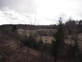
Close to the hashpoint, I noticed that the strip of forest had been felled a few years ago. There were lots of new saplings growing in it, but it was easy enough to traverse. I could walk with the bicycle and carry it all the way to the hashpoint. After documenting the visit, I walked back to the road again and carried on cycling. I still had more than 30 kilometres of road distance to cycle. Total distance was 67.7 kilometres.
I did indeed do a closed non-intersecting loop with the bicycle, required for the Tron achievement. However, I crossed my own track a couple of times on foot when I parked the bicycle and went to take pictures. This was not necessary to do, but better pictures make a better expedition report, so I think that I should not be disqualified because of these little side tracks. These are not visible in the GPS track because I kept the GPS receiver attached to the bicycle all the time.
Photos
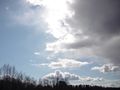
Rain clouds are coming and will soon obscure the sun.
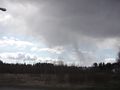
The huge rain cloud dominates the southern sky and barely misses me.
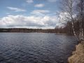
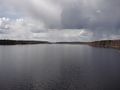
Pitkäsenlahti bay of Viinijärvi lake.
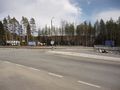
Road junction in Sotkuma.
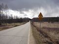
I did not enjoy seeing this sign... "Pavement damage for the next 13 km."
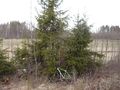
Bicycle parked at the hashpoint.
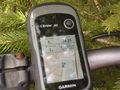
Hashpoint reached!
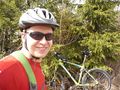
Me at the hashpoint.
The field next to the hashpoint. The bicycle is visible at the bottom.
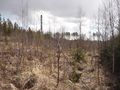
This is how the forest looks like now. Seems bad, but it was easy to walk through.
Käsämänsalmi strait of Viinijärvi lake, photographed on a bridge.
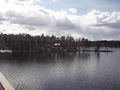
Same, other direction.
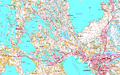
My tracklog (purple line) plotted on a topographic map.


Hmm, I apparently misnamed all the images. The dates in the filenames are 2020-05-16 instead of 2020-05-15. But it should not matter at all since there was never a 2020-05-16 62 29 expedition (the hashpoint is in a lake and would require a boat or swimming over 800 metres in cold water).
Achievements
Kripakko earned the Land geohash achievement
|
Kripakko earned the Bicycle geohash achievement
|
Kripakko earned the Tron achievement
|