Difference between revisions of "2020-05-16 47 -122"
From Geohashing
([live picture]Just managed to escape the rain [https://openstreetmap.org/?lat=47.68173320&lon=-122.40385190&zoom=16&layers=B000FTF @47.6817,-122.4039]) |
Coyotebush (talk | contribs) ([live] Heading out.) |
||
| Line 25: | Line 25: | ||
*Running a few minutes late, but it's all downhill from here! -- [[User:Thomcat|Thomcat]] ([[User talk:Thomcat|talk]]) [https://openstreetmap.org/?lat=47.69063930&lon=-122.38947620&zoom=16&layers=B000FTF @47.6906,-122.3895] 16:03, 16 May 2020 (PDT) | *Running a few minutes late, but it's all downhill from here! -- [[User:Thomcat|Thomcat]] ([[User talk:Thomcat|talk]]) [https://openstreetmap.org/?lat=47.69063930&lon=-122.38947620&zoom=16&layers=B000FTF @47.6906,-122.3895] 16:03, 16 May 2020 (PDT) | ||
| + | |||
| + | *Heading out. -- [[User:Coyotebush|Coyotebush]] ([[User talk:Coyotebush|talk]]) 17:45, 16 May 2020 (PDT) | ||
== Tracklog == | == Tracklog == | ||
<!-- if your GPS device keeps a log, you may post a link here --> | <!-- if your GPS device keeps a log, you may post a link here --> | ||
Revision as of 00:46, 17 May 2020
| Sat 16 May 2020 in Seattle: 47.6817281, -122.4040167 geohashing.info google osm bing/os kml crox |
Location
Public parking area at Shilshole Bay Marina.
Participants
Plans
High chance of rain, but plan to be there at 4:00.
- I might wait until later - looks like there may be a break in the rain between roughly 5 and 7. Will look for your chalk mark :) Coyotebush (talk) 21:05, 16 May 2020 (UTC)
Expedition
- Running a few minutes late, but it's all downhill from here! -- Thomcat (talk) @47.6906,-122.3895 16:03, 16 May 2020 (PDT)
- Heading out. -- Coyotebush (talk) 17:45, 16 May 2020 (PDT)
Tracklog
Photos

geohasher @47.6817,-122.4040
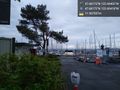
Shilshole marins @47.6817,-122.4042
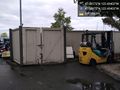
storage structures @47.6817,-122.4040
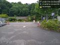
Controlled access @47.6819,-122.4042
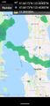
Just managed to escape the rain @47.6817,-122.4039


