Difference between revisions of "2020-06-07 -38 146"
Felix Dance (talk | contribs) m |
Felix Dance (talk | contribs) (Added expedition description) |
||
| Line 16: | Line 16: | ||
== Expedition == | == Expedition == | ||
| + | Ruth and I were on a three day cycle tour of the Strzlecki Ranges, south-east of Melbourne, enjoying the start of the easing of camping restrictions. I'd worked out the route in high-detail before the geohashes had come out. But then they did. | ||
| + | It was the evening of the first day when I checked the weekend's hashes. The plan was to skirt around the hilltop town of Mirboo North for the second day but a hash, almost directly on a road 3 kms outside Mirboo North, changed all that. Instead, we would ride directly into Mirboo North, then turn off to take the small road out of town to the hash. The price was a section of rail trail that would make the journey too long for the day. It was a price worth paying. | ||
| − | [https://www.strava.com/activities/3580825386 Here] is the Strava trace of the | + | The ride up into the town was a beautiful, sunny (but cold) winter's morning, surrounded by dairy farms and rolling hills. The ride to the hash was even simpler, downhill along a sealed road. We stopped as the metres ticked down to our final approach. |
| + | |||
| + | The hash itself was just up the side of a small embankment, right on the barb-wire fenced property boundary of a farm. I clambered up and stuck my arm into the hash, getting my phone to within 600 millimetres from the vertical line of the exact geohash. I took some photos of the surrounding area - the road, a narrow valley, a small dam storing water on someone's property - and headed back down to our bikes. We rode back up the hill and had lunch at Mirboo North's Grand Ridge Brewery, warming ourselves at the fire. | ||
| + | |||
| + | With a hash under our belts the rest of the day became more epic. We continued along the Strzlecki's Grand Ridge Rd, watching the bitumen become first narrower and then non-existent before ending in ruts and rocky corrigations. Just before sunset, when the air was significantly cooling, we turned off even that road and headed down a debris-strewn track into the Morwell River valley to our benighted campsite. | ||
| + | |||
| + | [https://www.strava.com/activities/3580825386 Here] is the Strava trace of the 80 km ride for the day. | ||
== Photos == | == Photos == | ||
Revision as of 02:33, 9 June 2020

| Sun 7 Jun 2020 in -38,146: -38.4081325, 146.1324659 geohashing.info google osm bing/os kml crox |
Location
On a road out of the town of Mirboo North, on Day 2 of a 3 day cycle tour of the Strzlecki Ranges.
Participants
- Felix Dance
- Ruth
Expedition
Ruth and I were on a three day cycle tour of the Strzlecki Ranges, south-east of Melbourne, enjoying the start of the easing of camping restrictions. I'd worked out the route in high-detail before the geohashes had come out. But then they did.
It was the evening of the first day when I checked the weekend's hashes. The plan was to skirt around the hilltop town of Mirboo North for the second day but a hash, almost directly on a road 3 kms outside Mirboo North, changed all that. Instead, we would ride directly into Mirboo North, then turn off to take the small road out of town to the hash. The price was a section of rail trail that would make the journey too long for the day. It was a price worth paying.
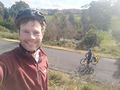
The ride up into the town was a beautiful, sunny (but cold) winter's morning, surrounded by dairy farms and rolling hills. The ride to the hash was even simpler, downhill along a sealed road. We stopped as the metres ticked down to our final approach.
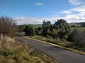
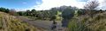
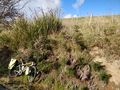
The hash itself was just up the side of a small embankment, right on the barb-wire fenced property boundary of a farm. I clambered up and stuck my arm into the hash, getting my phone to within 600 millimetres from the vertical line of the exact geohash. I took some photos of the surrounding area - the road, a narrow valley, a small dam storing water on someone's property - and headed back down to our bikes. We rode back up the hill and had lunch at Mirboo North's Grand Ridge Brewery, warming ourselves at the fire.
With a hash under our belts the rest of the day became more epic. We continued along the Strzlecki's Grand Ridge Rd, watching the bitumen become first narrower and then non-existent before ending in ruts and rocky corrigations. Just before sunset, when the air was significantly cooling, we turned off even that road and headed down a debris-strewn track into the Morwell River valley to our benighted campsite.
Here is the Strava trace of the 80 km ride for the day.
Photos
Standing at the hash
Hashroad
Panorama!
My bike next to the hash
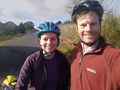
Felix and Ruth at the hash

GPS proof


Achievements
Felix Dance and Ruth earned the Bicycle geohash achievement
|