Difference between revisions of "2020-06-15 53 9"
Gumbledalf (talk | contribs) (Created page with "{{meetup graticule|lat=53|lon=9|date=2020-06-15}} ==Location== in some trees next to a sand mining area near a big lake in Kaltenkirchen, Schleswig-Holstein ==Participants==...") |
(→Photos: photos 47 of 120) |
||
| (3 intermediate revisions by 2 users not shown) | |||
| Line 2: | Line 2: | ||
==Location== | ==Location== | ||
| − | in some trees next to a sand mining area | + | in some trees next to a path by a beach at a big lake and near a sand mining area in Kaltenkirchen, Schleswig-Holstein |
==Participants== | ==Participants== | ||
| − | *[[User:π π π|π π π]] ([[User talk: | + | *[[User:π π π|π π π]] ([[User talk:π π π|talk]]) |
==Expedition== | ==Expedition== | ||
| − | + | After I finished my university work, I took the train to Holstentherme in the evening. The Holstentherme is a big leisure swimming facility where I learned to swim more than 15 years ago and was only 330 m from the hash. I cycled past it and stopped at a mound after a little over a kilometre. I originally thought the hash was just in some trees in an unoccupied (and possibly forbidden) area, as OSM had no paths there. But I discovered a much used path over the mound, which, to my surprise, led me to a big path from where I could see the Baggersee, the largest lake near my home, less than 40 m away and more than 10 people chilling at the beach. The hashpoint lay only 2 m from the path at the edge of a slope, and people passed me during my hashdance. | |
| − | + | After the photo-taking, I went down to the beach to take some photos of the lake and the nearby sand mining area (I had never seen one before). According to OSM, the hash was only 10 m from the sand extraction area because the beach is a part of it. When I rode back, I discovered another path that led directly to a good lookout over the mine, from where I got good pictures of it. Then I cycled 8 km home, taking the longer but quieter western route. | |
| − | + | ||
| − | <gallery | + | ==Photos== |
| + | <gallery> | ||
| + | File:2020-06-15 53 9 10.jpg | proof 1 | ||
| + | File:2020-06-15 53 9 11.jpg | proof 2 | ||
| + | File:2020-06-15 53 9 1.jpg | the hash | ||
| + | File:2020-06-15 53 9 2.jpg | pano 1 | ||
| + | File:2020-06-15 53 9 3.jpg | pano 2 | ||
| + | File:2020-06-15 53 9 4.jpg | π π π | ||
| + | File:2020-06-15 53 9 5.jpg | the ''Baggersee'', with swimmers | ||
| + | File:2020-06-15 53 9 6.jpg | artificial beach area | ||
| + | File:2020-06-15 53 9 7.jpg | where I parked my bike | ||
| + | File:2020-06-15 53 9 8.jpg | the sand mining area | ||
| + | File:2020-06-15 53 9 9.jpg | (continuation) | ||
</gallery> | </gallery> | ||
==Achievements== | ==Achievements== | ||
| − | Land geohash, Bicycle geohash, Public transport geohash | + | Land geohash, Bicycle geohash, Public transport geohash |
__NOTOC__ | __NOTOC__ | ||
[[Category:Expeditions]] | [[Category:Expeditions]] | ||
| − | + | [[Category:Coordinates reached]] | |
[[Category:Land geohash achievement]] | [[Category:Land geohash achievement]] | ||
[[Category:Bicycle geohash achievement]] | [[Category:Bicycle geohash achievement]] | ||
| − | [[Category:Public transport geohash achievement]] | + | [[Category:Public transport geohash achievement]] |
{{location|DE|SH|SE}} | {{location|DE|SH|SE}} | ||
Latest revision as of 19:53, 16 January 2022
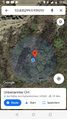
| Mon 15 Jun 2020 in 53,9: 53.8353017, 9.9392107 geohashing.info google osm bing/os kml crox |
Location
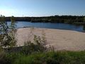
in some trees next to a path by a beach at a big lake and near a sand mining area in Kaltenkirchen, Schleswig-Holstein
Participants
Expedition
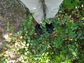
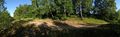
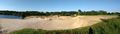
After I finished my university work, I took the train to Holstentherme in the evening. The Holstentherme is a big leisure swimming facility where I learned to swim more than 15 years ago and was only 330 m from the hash. I cycled past it and stopped at a mound after a little over a kilometre. I originally thought the hash was just in some trees in an unoccupied (and possibly forbidden) area, as OSM had no paths there. But I discovered a much used path over the mound, which, to my surprise, led me to a big path from where I could see the Baggersee, the largest lake near my home, less than 40 m away and more than 10 people chilling at the beach. The hashpoint lay only 2 m from the path at the edge of a slope, and people passed me during my hashdance.
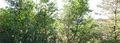
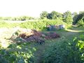
After the photo-taking, I went down to the beach to take some photos of the lake and the nearby sand mining area (I had never seen one before). According to OSM, the hash was only 10 m from the sand extraction area because the beach is a part of it. When I rode back, I discovered another path that led directly to a good lookout over the mine, from where I got good pictures of it. Then I cycled 8 km home, taking the longer but quieter western route.
Photos
proof 1

proof 2
the hash
pano 1
pano 2

π π π
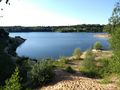
the Baggersee, with swimmers
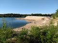
artificial beach area
where I parked my bike
the sand mining area
(continuation)


Achievements
Land geohash, Bicycle geohash, Public transport geohash