Difference between revisions of "2020-06-17 61 29"
(Created page with "{{Subst:Expedition}}") |
|||
| Line 1: | Line 1: | ||
| − | + | {{meetup graticule | |
| − | |||
| − | |||
| − | |||
| − | |||
| − | |||
| − | |||
| − | |||
| − | |||
| lat={{#explode:{{SUBPAGENAME}}| |1}} | | lat={{#explode:{{SUBPAGENAME}}| |1}} | ||
| lon={{#explode:{{SUBPAGENAME}}| |2}} | | lon={{#explode:{{SUBPAGENAME}}| |2}} | ||
| date={{#explode:{{SUBPAGENAME}}| |0}} | | date={{#explode:{{SUBPAGENAME}}| |0}} | ||
| − | }} | + | }} |
__NOTOC__ | __NOTOC__ | ||
== Location == | == Location == | ||
| − | + | In a young pine forest just 60 metres off highway 6. | |
| + | |||
| + | The point on a topographic map: [https://asiointi.maanmittauslaitos.fi/karttapaikka/?lang=en&share=customMarker&n=6855792.522&e=643779.325&title=Geohash+2020-06-17+61+29&desc=&zoom=10] | ||
== Participants == | == Participants == | ||
| − | + | *[[User:Kripakko|Kripakko]] | |
| − | |||
| − | |||
| − | |||
| − | |||
== Expedition == | == Expedition == | ||
| − | + | This hashpoint was exceptionally lucky since it was located very close to a road along which I would travel today. I visited South Karelia with my family, and on the way back I got the driver to stop the car so I could go and quickly find the hashpoint. The forest was young and dense but passable without too much pathfinding effort. I just took a few photos to document the visit and returned to the car, where I arrived five minutes after I had left. | |
| − | |||
| − | |||
| − | |||
== Photos == | == Photos == | ||
| − | |||
| − | |||
| − | |||
<gallery perrow="5"> | <gallery perrow="5"> | ||
| + | Image:2020-06-17_61_29_01-gpsr.jpg | Hashpoint reached! | ||
| + | Image:2020-06-17_61_29_02-selfie.jpg | Selfie at the hashpoint. | ||
| + | Image:2020-06-17_61_29_03-hashpoint.jpg | The hashpoint was located at the end of this opening. | ||
| + | Image:2020-06-17_61_29_04-lingonberry.jpg | Blossoming lingonberry (''Vaccinium vitis-idaea'') with grey reindeer lichen (''Cladonia rangiferina''). | ||
| + | Image:2020-06-17_61_29_05-forest.jpg | How the way to the hashpoint looked like. Somewhat difficult to walk through. | ||
</gallery> | </gallery> | ||
== Achievements == | == Achievements == | ||
{{#vardefine:ribbonwidth|800px}} | {{#vardefine:ribbonwidth|800px}} | ||
| − | + | {{land geohash | latitude=61 | longitude=29 | date=2020-06-17 | name=Kripakko}} | |
| − | |||
| − | |||
| − | |||
| − | |||
| − | |||
| − | |||
| − | |||
| − | |||
| − | |||
| − | |||
| − | |||
| − | |||
| − | |||
| − | |||
[[Category:Expeditions]] | [[Category:Expeditions]] | ||
| − | |||
[[Category:Expeditions with photos]] | [[Category:Expeditions with photos]] | ||
| − | |||
| − | |||
| − | |||
| − | |||
| − | |||
[[Category:Coordinates reached]] | [[Category:Coordinates reached]] | ||
| − | |||
| − | |||
| − | |||
| − | |||
| − | |||
| − | |||
| − | |||
| − | |||
| − | |||
| − | |||
| − | |||
| − | |||
| − | |||
| − | |||
| − | |||
| − | |||
| − | |||
| − | |||
Revision as of 19:41, 17 June 2020
| Wed 17 Jun 2020 in 61,29: 61.8078467, 29.7284761 geohashing.info google osm bing/os kml crox |
Location
In a young pine forest just 60 metres off highway 6.
The point on a topographic map: [1]
Participants
Expedition
This hashpoint was exceptionally lucky since it was located very close to a road along which I would travel today. I visited South Karelia with my family, and on the way back I got the driver to stop the car so I could go and quickly find the hashpoint. The forest was young and dense but passable without too much pathfinding effort. I just took a few photos to document the visit and returned to the car, where I arrived five minutes after I had left.
Photos
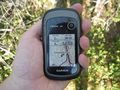
Hashpoint reached!
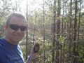
Selfie at the hashpoint.
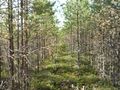
The hashpoint was located at the end of this opening.
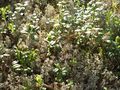
Blossoming lingonberry (Vaccinium vitis-idaea) with grey reindeer lichen (Cladonia rangiferina).
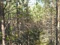
How the way to the hashpoint looked like. Somewhat difficult to walk through.


Achievements
Kripakko earned the Land geohash achievement
|