Difference between revisions of "2020-06-22 51 9"
From Geohashing
(new report) |
(expedition report for Juliusmühle) |
||
| Line 1: | Line 1: | ||
| − | + | {{meetup graticule | |
| − | |||
| − | |||
| − | |||
| − | |||
| − | |||
| − | |||
| − | |||
| − | |||
| lat={{#explode:{{SUBPAGENAME}}| |1}} | | lat={{#explode:{{SUBPAGENAME}}| |1}} | ||
| lon={{#explode:{{SUBPAGENAME}}| |2}} | | lon={{#explode:{{SUBPAGENAME}}| |2}} | ||
| date={{#explode:{{SUBPAGENAME}}| |0}} | | date={{#explode:{{SUBPAGENAME}}| |0}} | ||
| − | }} | + | }} |
| + | |||
__NOTOC__ | __NOTOC__ | ||
== Location == | == Location == | ||
| − | + | ||
| + | The hash lay on an old railway dam at Juliusmühle at Einbeck, but on the side of Markoldendorf/Dassel. | ||
== Participants == | == Participants == | ||
| − | + | ||
| − | + | [[User:GeorgDerReisende|GeorgDerReisende]] | |
== Plans == | == Plans == | ||
| − | + | ||
| + | Travel to Holtensen, walk to Juliusmühle. | ||
== Expedition == | == Expedition == | ||
| − | |||
| − | + | At first I traveled to Holtensen. Noteworthy the train from Göttingen to Einbeck started from an ICE platform. But the rest was normal. Then I walked to Juliusmühle and found there the hash. Between the road and the hash was a ditch and just behind the hash there was another ditch. Only at the second view I found out, that the hash lay on the old railway dam of the Ilmebahn. | |
| − | |||
== Photos == | == Photos == | ||
| − | < | + | |
| − | + | <gallery> | |
| − | -- | + | File:2020-06-22 51 9 GeorgDerReisende 6927.jpg | situation |
| − | + | File:2020-06-22 51 9 GeorgDerReisende 6928.jpg | first look to the hash | |
| + | File:2020-06-22 51 9 GeorgDerReisende 6929.jpg | better view | ||
| + | File:2020-06-22 51 9 GeorgDerReisende 6932.jpg | there it is | ||
| + | File:2020-06-22 51 9 GeorgDerReisende 6933.jpg | the ditch north of the hash | ||
| + | File:2020-06-22 51 9 GeorgDerReisende 6934.jpg | looking west | ||
| + | File:2020-06-22 51 9 GeorgDerReisende 6935.jpg | north | ||
| + | File:2020-06-22 51 9 GeorgDerReisende 6936.jpg | east | ||
| + | File:2020-06-22 51 9 GeorgDerReisende 6937.jpg | south | ||
| + | File:2020-06-22 51 9 GeorgDerReisende 6938.jpg | the geohasher | ||
</gallery> | </gallery> | ||
| − | + | [[Category:Expeditions]] | |
| − | |||
| − | |||
| − | + | [[Category:Expeditions with photos]] | |
| − | |||
| − | [[Category: | ||
| − | + | [[Category:Expedition without GPS]] | |
| − | |||
| − | |||
| − | |||
| − | |||
| − | |||
| − | |||
| − | |||
| − | |||
| − | |||
| − | |||
| − | |||
| − | |||
| − | |||
| − | |||
| − | |||
| − | |||
[[Category:Coordinates reached]] | [[Category:Coordinates reached]] | ||
| − | |||
| − | |||
| − | |||
| − | |||
| − | |||
| − | |||
| − | |||
| − | |||
| − | |||
| − | |||
| − | |||
| − | |||
| − | |||
| − | |||
| − | |||
| − | |||
| − | |||
| − | |||
Revision as of 14:44, 23 June 2020
| Mon 22 Jun 2020 in 51,9: 51.8198898, 9.7868422 geohashing.info google osm bing/os kml crox |
Location
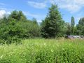
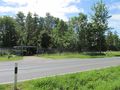
The hash lay on an old railway dam at Juliusmühle at Einbeck, but on the side of Markoldendorf/Dassel.
Participants
Plans
Travel to Holtensen, walk to Juliusmühle.
Expedition
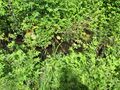
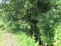
At first I traveled to Holtensen. Noteworthy the train from Göttingen to Einbeck started from an ICE platform. But the rest was normal. Then I walked to Juliusmühle and found there the hash. Between the road and the hash was a ditch and just behind the hash there was another ditch. Only at the second view I found out, that the hash lay on the old railway dam of the Ilmebahn.
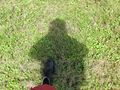
Photos
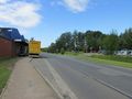
situation
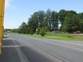
first look to the hash
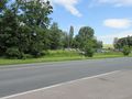
better view
there it is
the ditch north of the hash
looking west
north
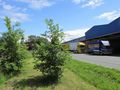
east
south

the geohasher


