Difference between revisions of "2020-06-25 51 7"
From Geohashing
(new report) |
(expedition report for Schwerte) |
||
| Line 1: | Line 1: | ||
| − | + | {{meetup graticule | |
| − | |||
| − | |||
| − | |||
| − | |||
| − | |||
| − | |||
| − | |||
| − | |||
| lat={{#explode:{{SUBPAGENAME}}| |1}} | | lat={{#explode:{{SUBPAGENAME}}| |1}} | ||
| lon={{#explode:{{SUBPAGENAME}}| |2}} | | lon={{#explode:{{SUBPAGENAME}}| |2}} | ||
| date={{#explode:{{SUBPAGENAME}}| |0}} | | date={{#explode:{{SUBPAGENAME}}| |0}} | ||
| − | }} | + | }} |
| + | |||
__NOTOC__ | __NOTOC__ | ||
== Location == | == Location == | ||
| − | + | ||
| + | The hash lay in a garden pavilion at the corner of Holzer Weg and Westhellweg in Schwerte. | ||
== Participants == | == Participants == | ||
| − | + | ||
| − | + | [[User:GeorgDerReisende|GeorgDerReisende]] | |
== Plans == | == Plans == | ||
| − | + | ||
| + | Take the train at 8:03 and a walk. | ||
== Expedition == | == Expedition == | ||
| − | |||
| − | + | Boring. Just a walk along the street. Taking some photos. The later walk through the Schwerter Heide and the Schwerter Forest was boring, too. At the bus stop at the end of my walk I arrived 1 hour and 54 minutes too early. | |
| − | |||
== Photos == | == Photos == | ||
| − | < | + | |
| − | + | <gallery> | |
| − | -- | + | File:2020-06-25 51 7 GeorgDerReisende 7261.jpg | arrived |
| − | + | File:2020-06-25 51 7 GeorgDerReisende 7301.jpg | the hash is at the pavilion behind the hedge | |
| + | File:2020-06-25 51 7 GeorgDerReisende 7302.jpg | looking Holzer Weg to town | ||
| + | File:2020-06-25 51 7 GeorgDerReisende 7303.jpg | the pavilion behind the hedge | ||
| + | File:2020-06-25 51 7 GeorgDerReisende 7304.jpg | Westhellweg to east | ||
| + | File:2020-06-25 51 7 GeorgDerReisende 7305.jpg | Westhellweg to west | ||
| + | File:2020-06-25 51 7 GeorgDerReisende 7306.jpg | Holzer Weg to north | ||
| + | File:2020-06-25 51 7 GeorgDerReisende 7308.jpg | the geohasher | ||
</gallery> | </gallery> | ||
| − | + | [[Category:Expeditions]] | |
| − | |||
| − | |||
| − | + | [[Category:Expeditions with photos]] | |
| − | |||
| − | [[Category: | ||
| − | + | [[Category:Expedition without GPS]] | |
| − | |||
| − | |||
| − | |||
| − | |||
| − | |||
| − | |||
| − | |||
| − | |||
| − | |||
| − | |||
| − | |||
| − | |||
| − | |||
| − | |||
| − | |||
| − | |||
[[Category:Coordinates reached]] | [[Category:Coordinates reached]] | ||
| − | |||
| − | |||
| − | |||
| − | |||
| − | |||
| − | |||
| − | |||
| − | |||
| − | |||
| − | |||
| − | |||
| − | |||
| − | |||
| − | |||
| − | |||
| − | |||
| − | |||
| − | |||
Revision as of 08:34, 26 June 2020
| Thu 25 Jun 2020 in 51,7: 51.4457505, 7.5448210 geohashing.info google osm bing/os kml crox |
Location
The hash lay in a garden pavilion at the corner of Holzer Weg and Westhellweg in Schwerte.
Participants
Plans
Take the train at 8:03 and a walk.
Expedition
Boring. Just a walk along the street. Taking some photos. The later walk through the Schwerter Heide and the Schwerter Forest was boring, too. At the bus stop at the end of my walk I arrived 1 hour and 54 minutes too early.
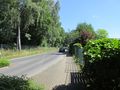
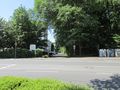
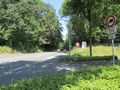
Photos
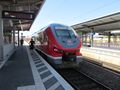
arrived
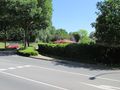
the hash is at the pavilion behind the hedge
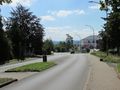
looking Holzer Weg to town
the pavilion behind the hedge
Westhellweg to east
Westhellweg to west
Holzer Weg to north
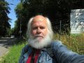
the geohasher


