Difference between revisions of "2020-06-26 62 28"
(Created page with "{{Subst:Expedition}}") |
m |
||
| (4 intermediate revisions by 2 users not shown) | |||
| Line 1: | Line 1: | ||
| − | + | {{meetup graticule | |
| − | |||
| − | |||
| − | |||
| − | |||
| − | |||
| − | |||
| − | |||
| − | |||
| lat={{#explode:{{SUBPAGENAME}}| |1}} | | lat={{#explode:{{SUBPAGENAME}}| |1}} | ||
| lon={{#explode:{{SUBPAGENAME}}| |2}} | | lon={{#explode:{{SUBPAGENAME}}| |2}} | ||
| date={{#explode:{{SUBPAGENAME}}| |0}} | | date={{#explode:{{SUBPAGENAME}}| |0}} | ||
| − | }} | + | }} |
__NOTOC__ | __NOTOC__ | ||
== Location == | == Location == | ||
| − | + | In a forest near the village of Härkki in Enonkoski. | |
| + | |||
| + | The point on a topographic map: [https://asiointi.maanmittauslaitos.fi/karttapaikka/?lang=en&share=customMarker&n=6895705.403&e=594774.818&title=Geohash+2020-06-26+62+28&desc=&zoom=10] | ||
== Participants == | == Participants == | ||
| − | + | *[[User:Kripakko|Kripakko]] | |
| − | |||
| − | == | + | == Expedition == |
| − | + | I got the insane idea of cycling to this hashpoint and to Heinävesi railway station where I would catch a train back to Joensuu at 21:45. Insane because the sun was shining on a clear sky and the temperature was about 30 °C, almost too hot for me. (''Edit: The local newspaper Karjalainen reported 27 °C in Joensuu and 29 °C in Liperi and Savonlinna, so it was slightly less than 30 °C.'') I would have to cycle almost 140 kilometres in the scorching heat, and still having muscle fatigue after an orienteering practice yesterday did not help. | |
| − | + | I left from home at about one o'clock. My legs were indeed a little tired, and somewhat strong westerly wind blew against me. I could still cycle at a good speed in spite of that, though I grew more tired over time and had to take many pauses and drink a lot of water. In fact, I ended up consuming five litres of water during the trip, in less than twelve hours. My progress was good enough that I did not need to turn back, and so I kept cycling and committed to my plan. I cycled via Ylämylly and Liperi towards Heinävesi. | |
| − | + | ||
| + | After turning to Pölläkäntie road towards Enonkoski, the terrain became more uneven. I had to climb many tiring uphills and descend downhills which gave me almost terrifying speeds (up to 50 km/h). Elevation differences were in the order of tens of metres. It was not surprising though since this region ([https://en.wikipedia.org/wiki/Finnish_Lakeland Finnish Lakeland]) is known for its abundance of lakes and ponds and hills between them. This is obvious when looking at the map. | ||
| + | |||
| + | Eventually I reached the hashpoint and continued cycling after taking a few quick photographs. I did not have plenty of time to spare, and I was being eaten alive by horseflies and blackflies. The road to Heinävesi railway station was very hilly and mostly unpaved, but there were a few beautiful views to lakes too. I grew more tired and had to ride slower than before, but I was still conveniently on schedule to reach the station on time. | ||
| + | |||
| + | I arrived at the railway station at 21:22, 23 minutes before the train's arrival... or so I thought. First it was announced that it would be 25 minutes late, which eventually turned into 35 minutes. I went to find a geocache on Raaminmäki to kill some time and came back to wait. Finally the train arrived, and after an hour I was in Joensuu again with a little over three kilometres to cycle until I got home. | ||
| + | |||
| + | According to my GPS receiver, the distance of the trip was 241.3 km, of which I cycled 142.6 km and travelled 98.7 km by train. However, GPS reception was very bad in the train, and I even lost signal altogether when it went to the north, so the train distance is unreliable. I kept the train journey in the tracklog though because I found it funny. Especially around the stop at Vihtari the location errors are amusingly severe. | ||
== Tracklog == | == Tracklog == | ||
| − | + | {{tracklog | 2020-06-26 62 28 tracklog.gpx}} | |
| − | == Photos == | + | == Photos == |
| − | < | + | <gallery perrow="6"> |
| − | + | 2020-06-26_62_28_01-fields1.jpg | Fields near the village of Niva. | |
| − | -- | + | 2020-06-26_62_28_02-lake1.jpg | The Onkisalmi strait. |
| − | + | 2020-06-26_62_28_03-border.jpg | At the border of Savonia and Karelia. | |
| + | 2020-06-26_62_28_04-hill.jpg | View to lake Suuri-Pölläkkä. | ||
| + | 2020-06-26_62_28_18-border2.jpg | At the border of Savonlinna (former Savonranta) and Enonkoski. | ||
| + | 2020-06-26_62_28_05-fields2.jpg | Fields at Suurimäki. | ||
| + | 2020-06-26_62_28_06-horses.jpg | Horses spending time outside. | ||
| + | 2020-06-26_62_28_07-bicycle.jpg | Bicycle at the roadside, about twenty metres to go. | ||
| + | 2020-06-26_62_28_08-gpsr.jpg | GPS receiver at the hashpoint. | ||
| + | 2020-06-26_62_28_09-selfie.jpg | Me at the hashpoint, quite tired already. | ||
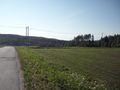
| + | 2020-06-26_62_28_10-fields3.jpg | View to fields and lake Ruunavesi. | ||
| + | 2020-06-26_62_28_11-lake2.jpg | The Hyväsalmi strait. | ||
| + | 2020-06-26_62_28_12-lake3.jpg | The Kerivirta strait. | ||
| + | 2020-06-26_62_28_13-lake4.jpg | An unnamed strait at the other end of Mustasaari. | ||
| + | 2020-06-26_62_28_14-loggingarea.jpg | View to a logging field near Kiikkurinne hill. | ||
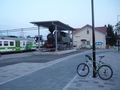
| + | 2020-06-26_62_28_15-station1.jpg | Heinävesi railway station. | ||
| + | 2020-06-26_62_28_16-train.jpg | The train is finally arriving 35 minutes late. | ||
| + | 2020-06-26_62_28_17-station2.jpg | Joensuu railway station. | ||
</gallery> | </gallery> | ||
== Achievements == | == Achievements == | ||
{{#vardefine:ribbonwidth|800px}} | {{#vardefine:ribbonwidth|800px}} | ||
| − | |||
| − | |||
| − | |||
| − | |||
| − | |||
| − | |||
| − | |||
| − | |||
| − | |||
| − | |||
| − | |||
| − | |||
| − | + | {{land geohash | latitude = 62 | longitude = 28 | date = 2020-06-26 | name = Kripakko}} | |
| + | {{Minesweeper geohash | graticule = Joensuu, Finland | ranknumber = 5 | n = true | e = true | se = true | s = true | w = true | name = Kripakko}} | ||
| − | |||
[[Category:Expeditions]] | [[Category:Expeditions]] | ||
| − | |||
[[Category:Expeditions with photos]] | [[Category:Expeditions with photos]] | ||
| − | |||
| − | |||
| − | |||
| − | |||
| − | |||
[[Category:Coordinates reached]] | [[Category:Coordinates reached]] | ||
| − | + | {{location|FI|04}} | |
| − | |||
| − | |||
| − | |||
| − | |||
| − | |||
| − | |||
| − | |||
| − | |||
| − | |||
| − | |||
| − | |||
| − | |||
| − | |||
| − | |||
| − | |||
| − | |||
| − | |||
Latest revision as of 12:57, 29 June 2020
| Fri 26 Jun 2020 in 62,28: 62.1812657, 28.8204608 geohashing.info google osm bing/os kml crox |
Location
In a forest near the village of Härkki in Enonkoski.
The point on a topographic map: [1]
Participants
Expedition
I got the insane idea of cycling to this hashpoint and to Heinävesi railway station where I would catch a train back to Joensuu at 21:45. Insane because the sun was shining on a clear sky and the temperature was about 30 °C, almost too hot for me. (Edit: The local newspaper Karjalainen reported 27 °C in Joensuu and 29 °C in Liperi and Savonlinna, so it was slightly less than 30 °C.) I would have to cycle almost 140 kilometres in the scorching heat, and still having muscle fatigue after an orienteering practice yesterday did not help.
I left from home at about one o'clock. My legs were indeed a little tired, and somewhat strong westerly wind blew against me. I could still cycle at a good speed in spite of that, though I grew more tired over time and had to take many pauses and drink a lot of water. In fact, I ended up consuming five litres of water during the trip, in less than twelve hours. My progress was good enough that I did not need to turn back, and so I kept cycling and committed to my plan. I cycled via Ylämylly and Liperi towards Heinävesi.
After turning to Pölläkäntie road towards Enonkoski, the terrain became more uneven. I had to climb many tiring uphills and descend downhills which gave me almost terrifying speeds (up to 50 km/h). Elevation differences were in the order of tens of metres. It was not surprising though since this region (Finnish Lakeland) is known for its abundance of lakes and ponds and hills between them. This is obvious when looking at the map.
Eventually I reached the hashpoint and continued cycling after taking a few quick photographs. I did not have plenty of time to spare, and I was being eaten alive by horseflies and blackflies. The road to Heinävesi railway station was very hilly and mostly unpaved, but there were a few beautiful views to lakes too. I grew more tired and had to ride slower than before, but I was still conveniently on schedule to reach the station on time.
I arrived at the railway station at 21:22, 23 minutes before the train's arrival... or so I thought. First it was announced that it would be 25 minutes late, which eventually turned into 35 minutes. I went to find a geocache on Raaminmäki to kill some time and came back to wait. Finally the train arrived, and after an hour I was in Joensuu again with a little over three kilometres to cycle until I got home.
According to my GPS receiver, the distance of the trip was 241.3 km, of which I cycled 142.6 km and travelled 98.7 km by train. However, GPS reception was very bad in the train, and I even lost signal altogether when it went to the north, so the train distance is unreliable. I kept the train journey in the tracklog though because I found it funny. Especially around the stop at Vihtari the location errors are amusingly severe.
Tracklog
Photos
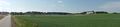
Fields near the village of Niva.
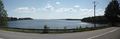
The Onkisalmi strait.
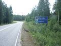
At the border of Savonia and Karelia.
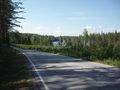
View to lake Suuri-Pölläkkä.
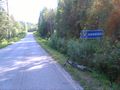
At the border of Savonlinna (former Savonranta) and Enonkoski.
Fields at Suurimäki.
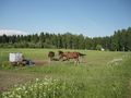
Horses spending time outside.
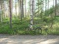
Bicycle at the roadside, about twenty metres to go.
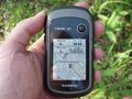
GPS receiver at the hashpoint.
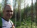
Me at the hashpoint, quite tired already.

View to fields and lake Ruunavesi.
The Hyväsalmi strait.
The Kerivirta strait.
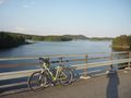
An unnamed strait at the other end of Mustasaari.
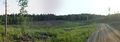
View to a logging field near Kiikkurinne hill.
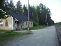
Heinävesi railway station.
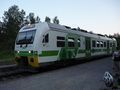
The train is finally arriving 35 minutes late.
Joensuu railway station.


Achievements
Kripakko earned the Land geohash achievement
|
Kripakko achieved level 5 of the Minesweeper Geohash achievement
|