Difference between revisions of "2020-07-11 49 8"
([live picture]Close) |
|||
| (9 intermediate revisions by 3 users not shown) | |||
| Line 1: | Line 1: | ||
| − | + | {{meetup graticule | |
| − | |||
| − | |||
| − | |||
| − | |||
| − | |||
| − | |||
| − | |||
| − | |||
| lat=49 | | lat=49 | ||
| lon=8 | | lon=8 | ||
| date=2020-07-11 | | date=2020-07-11 | ||
| − | }} | + | }} |
| + | |||
__NOTOC__ | __NOTOC__ | ||
| + | |||
== Location == | == Location == | ||
<!-- where you've surveyed the hash to be --> | <!-- where you've surveyed the hash to be --> | ||
| + | In the middle of a golf course | ||
== Participants == | == Participants == | ||
<!-- who attended: If you link to your wiki user name in this section, your expedition will be picked up by the various statistics generated for geohashing. You may use three tildes ~ as a shortcut to automatically insert the user signature of the account you are editing with. | <!-- who attended: If you link to your wiki user name in this section, your expedition will be picked up by the various statistics generated for geohashing. You may use three tildes ~ as a shortcut to automatically insert the user signature of the account you are editing with. | ||
--> | --> | ||
| + | * [[User:Lyrla|Lyrla]] | ||
== Plans == | == Plans == | ||
<!-- what were the original plans --> | <!-- what were the original plans --> | ||
| + | |||
| + | Go there 30-35 km by bike, find my first hash ever, find another bike path back, send the report to my collegue [[User:Mampfred|Mampfred]] who brought me here | ||
== Expedition == | == Expedition == | ||
<!-- how it all turned out. your narrative goes here. --> | <!-- how it all turned out. your narrative goes here. --> | ||
| + | When I arrived, I found out that the hash was in the middle of a golf course and there were lots of people around playing golf. | ||
| + | |||
| + | I saw no signs that said "private property" but some that recommended me to not enter the course because of danger to life | ||
| + | I had to get around 300m into the course so I had to wait for a good moment when not many people where playing on the route I was planning to take. After 30 minutes of waiting time was right. | ||
| + | So I snuck (wtf english language, get your things straight) around like Ethan Hunt (Tom Cruise) from Mission Impossible playing a World of Warcraft Rogue to prevent people from seeing me, hiding behind bushes and crossing the greens when noone looked. I arrived at the hash, had no idea how to log my arrival in the app I downloaded the night before, clicked something in panic and fear to get spotted before I am able to log, took some photos and left. | ||
| + | |||
| + | So I got successfully demugglelized today. | ||
| + | |||
| + | When I was done, I reckognized that the Riedsee, a lake I had heard of a lot, is pretty close to the hash, around 4 km almost my direction home. I decided to go there and have a look. I took some photos, so you can decide yourself whether it was worth it or not. | ||
| + | |||
| + | My way back wasn't fun because I got a lot of headwind but all in all it was a good experience. | ||
| − | * | + | Across the day, I saw more of the strange bois you can see in the photo below in one day than I saw in my entire life combined (~80-100). I know they are called stork, but I prefer calling them strange boi, because they look strange. |
| − | + | ||
| − | + | *?!?!?! -- [[User:Lyrla|Lyrla]] ([[User talk:Lyrla|talk]]) [https://openstreetmap.org/?lat=49.86374160&lon=8.46726880&zoom=16&layers=B000FTF @49.8637,8.4673] 18:30, 11 July 2020 (GMT+02:00) | |
== Photos == | == Photos == | ||
| Line 37: | Line 46: | ||
<gallery perrow="5"> | <gallery perrow="5"> | ||
| − | Image:2020-07-11_49_8_Lyrla_1594484961252.jpg| | + | Image:2020-07-11_49_8_Lyrla_1594484961252.jpg|at the Hash [https://openstreetmap.org/?lat=49.86371420&lon=8.46725320&zoom=16&layers=B000FTF @49.8637,8.4673] |
| − | + | Image:2020-07-11 49 8 Lyrla 1594496829405.jpg|at the Hash | |
| − | Image:2020-07- | + | Image:2020-07-11 49 8 Lyrla 1594496909168.jpg|at the Hash |
| − | + | Image:2020-07-11 49 8 Lyrla 1594496926461.jpg|at the Hash | |
| − | Image:2020-07- | + | Image:2020-07-11 49 8 Lyrla 1594496944872.jpg|close to the Hash |
| + | Image:2020-07-11 49 8 Lyrla 1594497135807.jpg|a strange boi | ||
| + | Image:2020-07-11 49 8 Lyrla 1594497156842.jpg|Riedsee | ||
| + | Image:2020-07-11 49 8 Lyrla 1594497231768.jpg|Riedsee | ||
| − | |||
| − | |||
| − | |||
</gallery> | </gallery> | ||
== Achievements == | == Achievements == | ||
{{#vardefine:ribbonwidth|800px}} | {{#vardefine:ribbonwidth|800px}} | ||
| − | + | {{Land geohash | |
| − | + | | latitude = 49 | |
| − | + | | longitude = 8 | |
| − | + | | date = 2020-07-11 | |
| − | [[ | + | | name = [[User:Lyrla|Lyrla]] |
| − | + | }} | |
| − | + | {{bicycle geohash | |
| − | + | | latitude = 49 | |
| − | + | | longitude = 8 | |
| − | + | | date = 2020-07-11 | |
| − | [[ | + | | name = [[User:Lyrla|Lyrla]] |
| − | + | | distance = 60km | |
| − | + | | bothways = true | |
| − | + | }} | |
| − | |||
[[Category:Expeditions]] | [[Category:Expeditions]] | ||
| − | |||
[[Category:Expeditions with photos]] | [[Category:Expeditions with photos]] | ||
| − | |||
| − | |||
| − | |||
| − | |||
| − | |||
[[Category:Coordinates reached]] | [[Category:Coordinates reached]] | ||
| − | + | {{location|DE|HE|GG}} | |
| − | |||
| − | |||
| − | |||
| − | |||
| − | |||
| − | |||
| − | |||
| − | |||
| − | |||
| − | |||
| − | |||
| − | |||
| − | |||
| − | |||
| − | |||
| − | |||
| − | |||
Latest revision as of 09:42, 12 July 2020
| Sat 11 Jul 2020 in 49,8: 49.8637221, 8.4672808 geohashing.info google osm bing/os kml crox |
Location
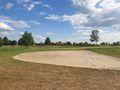
In the middle of a golf course
Participants
Plans
Go there 30-35 km by bike, find my first hash ever, find another bike path back, send the report to my collegue Mampfred who brought me here
Expedition
When I arrived, I found out that the hash was in the middle of a golf course and there were lots of people around playing golf.
I saw no signs that said "private property" but some that recommended me to not enter the course because of danger to life I had to get around 300m into the course so I had to wait for a good moment when not many people where playing on the route I was planning to take. After 30 minutes of waiting time was right. So I snuck (wtf english language, get your things straight) around like Ethan Hunt (Tom Cruise) from Mission Impossible playing a World of Warcraft Rogue to prevent people from seeing me, hiding behind bushes and crossing the greens when noone looked. I arrived at the hash, had no idea how to log my arrival in the app I downloaded the night before, clicked something in panic and fear to get spotted before I am able to log, took some photos and left.
So I got successfully demugglelized today.
When I was done, I reckognized that the Riedsee, a lake I had heard of a lot, is pretty close to the hash, around 4 km almost my direction home. I decided to go there and have a look. I took some photos, so you can decide yourself whether it was worth it or not.
My way back wasn't fun because I got a lot of headwind but all in all it was a good experience.
Across the day, I saw more of the strange bois you can see in the photo below in one day than I saw in my entire life combined (~80-100). I know they are called stork, but I prefer calling them strange boi, because they look strange.
- ?!?!?! -- Lyrla (talk) @49.8637,8.4673 18:30, 11 July 2020 (GMT+02:00)
Photos
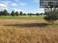
at the Hash @49.8637,8.4673
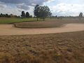
at the Hash
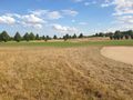
at the Hash
at the Hash
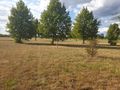
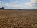
close to the Hash
a strange boi
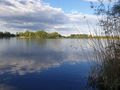
Riedsee
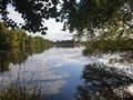
Riedsee


Achievements
Lyrla earned the Land geohash achievement
|
Lyrla earned the Bicycle geohash achievement
|