Difference between revisions of "2020-07-13 67 24"
(Created page with "{{Subst:Expedition}}") |
|||
| Line 1: | Line 1: | ||
| − | + | {{meetup graticule | |
| − | |||
| − | |||
| − | |||
| − | |||
| − | |||
| − | |||
| − | |||
| − | |||
| lat={{#explode:{{SUBPAGENAME}}| |1}} | | lat={{#explode:{{SUBPAGENAME}}| |1}} | ||
| lon={{#explode:{{SUBPAGENAME}}| |2}} | | lon={{#explode:{{SUBPAGENAME}}| |2}} | ||
| date={{#explode:{{SUBPAGENAME}}| |0}} | | date={{#explode:{{SUBPAGENAME}}| |0}} | ||
| − | }} | + | }} |
__NOTOC__ | __NOTOC__ | ||
== Location == | == Location == | ||
| − | + | On a former field near highway 79 in Kittilä. | |
| + | |||
| + | The point on a topographic map: [https://asiointi.maanmittauslaitos.fi/karttapaikka/?lang=en&share=customMarker&n=7458616.045&e=410067.733&title=Geohash+2020-07-13+67+24&desc=&zoom=10] | ||
== Participants == | == Participants == | ||
| − | + | *[[User:Kripakko|Kripakko]] | |
| − | + | *A milliard mosquitoes | |
| − | == | + | == Expedition == |
| − | + | I went for a road trip to northern Norway with my friend, and naturally I checked every day if any hashpoints would lie by our route. I would have liked an accessible point in the north, especially in a virgin graticule, but I would have had to get extremely lucky to get one. In the mountainous terrain, even a hundred metres off a road can be too difficult or time-consuming to reach. I did not want to waste much time doing geohashing since we had more important things to spend time on. | |
| − | == | + | This hashpoint was the only one on the route that was accessible easily enough. It was still not easy even on paper: the terrain was swamp and overgrown field. I chose a parking spot to the northeast [https://asiointi.maanmittauslaitos.fi/karttapaikka/?lang=en&share=customMarker&n=7458887.123&e=410231.429&title=Parking+spot&desc=&zoom=10]; there may have been an easier route from the southeast, but I did not want to park and walk so near the house that was there. The walking distance would be about 320 metres in one way, so nothing too bad. The friend stayed in the car, so I went alone. |
| − | |||
| − | + | I changed my shoes to long-legged rubber boots, which was the only sensible choice in the terrain. The swamp was wet, and there were wide trenches in the field, over which I could not quite jump. Also, vegetation was damp from rain some hours ago. The vegetation was densest around the trenches, making traversing the field even more difficult. I could eventually find my way to the hashpoint though. I took a few pictures and left. | |
| − | |||
== Photos == | == Photos == | ||
| − | |||
| − | |||
| − | |||
<gallery perrow="5"> | <gallery perrow="5"> | ||
| + | Image:2020-07-13_67_24_01-parkingspot.jpg | Where we parked the car, about 320 metres to go. | ||
| + | Image:2020-07-13_67_24_02-swamp.jpg | The swamp was wet but well accessible. | ||
| + | Image:2020-07-13_67_24_03-field1.jpg | View to the former field, about 100 metres to go. | ||
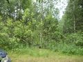
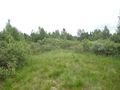
| + | Image:2020-07-13_67_24_04-hashpoint.jpg | The hashpoint was at the tall willow in the middle. | ||
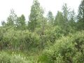
| + | Image:2020-07-13_67_24_05-field2.jpg | View to the east. | ||
| + | Image:2020-07-13_67_24_06-gpsr1.jpg | Hashpoint reached. | ||
| + | Image:2020-07-13_67_24_07-gpsr2.jpg | Proof of the date, in case you do not believe. | ||
| + | Image:2020-07-13_67_24_08-selfie.jpg | Selfie at the hashpoint with mosquito friends. | ||
| + | Image:2020-07-13_67_24_09-boots.jpg | Rubber boots are awesome, my legs were damp up to the knees. | ||
</gallery> | </gallery> | ||
== Achievements == | == Achievements == | ||
{{#vardefine:ribbonwidth|800px}} | {{#vardefine:ribbonwidth|800px}} | ||
| − | + | {{land geohash | latitude = 67 | longitude = 24 | date = 2020-07-13 | name = Kripakko}} | |
| − | |||
| − | |||
| − | |||
| − | |||
| − | |||
| − | |||
| − | |||
| − | |||
| − | |||
| − | |||
| − | |||
| − | |||
| − | |||
| − | |||
[[Category:Expeditions]] | [[Category:Expeditions]] | ||
| − | |||
[[Category:Expeditions with photos]] | [[Category:Expeditions with photos]] | ||
| − | |||
| − | |||
| − | |||
| − | |||
| − | |||
[[Category:Coordinates reached]] | [[Category:Coordinates reached]] | ||
| − | |||
| − | |||
| − | |||
| − | |||
| − | |||
| − | |||
| − | |||
| − | |||
| − | |||
| − | |||
| − | |||
| − | |||
| − | |||
| − | |||
| − | |||
| − | |||
| − | |||
| − | |||
Revision as of 21:44, 15 July 2020
| Mon 13 Jul 2020 in 67,24: 67.2307938, 24.9173701 geohashing.info google osm bing/os kml crox |
Location
On a former field near highway 79 in Kittilä.
The point on a topographic map: [1]
Participants
- Kripakko
- A milliard mosquitoes
Expedition
I went for a road trip to northern Norway with my friend, and naturally I checked every day if any hashpoints would lie by our route. I would have liked an accessible point in the north, especially in a virgin graticule, but I would have had to get extremely lucky to get one. In the mountainous terrain, even a hundred metres off a road can be too difficult or time-consuming to reach. I did not want to waste much time doing geohashing since we had more important things to spend time on.
This hashpoint was the only one on the route that was accessible easily enough. It was still not easy even on paper: the terrain was swamp and overgrown field. I chose a parking spot to the northeast [2]; there may have been an easier route from the southeast, but I did not want to park and walk so near the house that was there. The walking distance would be about 320 metres in one way, so nothing too bad. The friend stayed in the car, so I went alone.
I changed my shoes to long-legged rubber boots, which was the only sensible choice in the terrain. The swamp was wet, and there were wide trenches in the field, over which I could not quite jump. Also, vegetation was damp from rain some hours ago. The vegetation was densest around the trenches, making traversing the field even more difficult. I could eventually find my way to the hashpoint though. I took a few pictures and left.
Photos
Where we parked the car, about 320 metres to go.
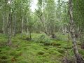
The swamp was wet but well accessible.
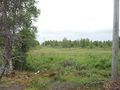
View to the former field, about 100 metres to go.
The hashpoint was at the tall willow in the middle.
View to the east.
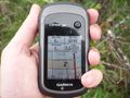
Hashpoint reached.
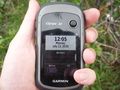
Proof of the date, in case you do not believe.
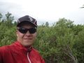
Selfie at the hashpoint with mosquito friends.
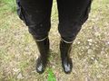
Rubber boots are awesome, my legs were damp up to the knees.


Achievements
Kripakko earned the Land geohash achievement
|