Difference between revisions of "2020-07-20 52 4"
FelixTheCat (talk | contribs) (Created page with "{{subst:Expedition |lat = 52 |lon = 4 |date = 2020-07-20 }}") |
FelixTheCat (talk | contribs) |
||
| Line 1: | Line 1: | ||
| − | + | {{meetup graticule | |
| − | |||
| − | |||
| − | |||
| − | |||
| − | |||
| − | |||
| − | |||
| − | |||
| lat=52 | | lat=52 | ||
| lon=4 | | lon=4 | ||
| date=2020-07-20 | | date=2020-07-20 | ||
| − | }} | + | }} |
__NOTOC__ | __NOTOC__ | ||
== Location == | == Location == | ||
| − | + | Vlietland recreational area, Leidschendam, Zuid-Holland province. | |
== Participants == | == Participants == | ||
| − | + | * [[User:FelixTheCat|FelixTheCat]] ([[User talk:FelixTheCat|talk]]) | |
| − | + | * Kat the Awesome | |
| − | |||
| − | |||
| − | |||
== Expedition == | == Expedition == | ||
| − | + | Kat and I had been planning to visit this hash after work. Unfortunately, I had to finish a few things at my job and didn't arrive home until 19:30. Luckily, Kat had already made dinner and the weather was nice, and with still an hour and a half of sunlight remaining we decided to go for it. After a twenty-minute drive we arrived at Vlietland's #3 car park, and found the hash after about 100 metres. We then walked around a bit. There were people relaxing by the beach, walking their dogs and even flying model floatplanes. | |
| − | |||
| − | |||
| − | |||
== Photos == | == Photos == | ||
| − | |||
| − | |||
| − | |||
<gallery perrow="5"> | <gallery perrow="5"> | ||
| + | Image:2020-07-20 52 4 FelixTheCat 1.JPG | Arriving at Vlietland. | ||
| + | Image:2020-07-20 52 4 FelixTheCat 2.JPG | The hash is here in front of this reed bed. | ||
| + | Image:2020-07-20 52 4 FelixTheCat 3.JPG | Right here. | ||
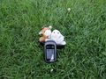
| + | Image:2020-07-20 52 4 FelixTheCat 4.png | GPS proof. | ||
| + | Image:2020-07-20 52 4 FelixTheCat 5.JPG | Lloyd and Harriet celebrating another success. | ||
| + | Image:2020-07-20 52 4 FelixTheCat 6.JPG | The sun setting over Lake Vlietland. | ||
</gallery> | </gallery> | ||
== Achievements == | == Achievements == | ||
{{#vardefine:ribbonwidth|800px}} | {{#vardefine:ribbonwidth|800px}} | ||
| − | + | {{land geohash | |
| − | + | | latitude = 52 | |
| − | + | | longitude = 4 | |
| − | + | | date = 2020-07-20 | |
| − | + | | name = [[User:FelixTheCat|FelixTheCat]] ([[User talk:FelixTheCat|talk]]) and Kat the Awesome | |
| − | + | }} | |
| − | |||
| − | |||
| − | |||
| − | |||
| − | [[ | ||
| − | |||
| − | |||
| − | |||
| − | |||
| − | |||
[[Category:Expeditions]] | [[Category:Expeditions]] | ||
| − | |||
[[Category:Expeditions with photos]] | [[Category:Expeditions with photos]] | ||
| − | |||
| − | |||
| − | |||
| − | |||
| − | |||
[[Category:Coordinates reached]] | [[Category:Coordinates reached]] | ||
| − | |||
| − | |||
| − | |||
| − | |||
| − | |||
| − | |||
| − | |||
| − | |||
| − | |||
| − | |||
| − | |||
| − | |||
| − | |||
| − | |||
| − | |||
| − | |||
| − | |||
| − | |||
Revision as of 21:16, 20 July 2020
| Mon 20 Jul 2020 in 52,4: 52.1217385, 4.4662323 geohashing.info google osm bing/os kml crox |
Location
Vlietland recreational area, Leidschendam, Zuid-Holland province.
Participants
- FelixTheCat (talk)
- Kat the Awesome
Expedition
Kat and I had been planning to visit this hash after work. Unfortunately, I had to finish a few things at my job and didn't arrive home until 19:30. Luckily, Kat had already made dinner and the weather was nice, and with still an hour and a half of sunlight remaining we decided to go for it. After a twenty-minute drive we arrived at Vlietland's #3 car park, and found the hash after about 100 metres. We then walked around a bit. There were people relaxing by the beach, walking their dogs and even flying model floatplanes.
Photos
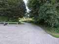
Arriving at Vlietland.
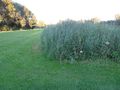
The hash is here in front of this reed bed.
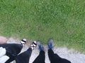
Right here.
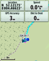
GPS proof.
Lloyd and Harriet celebrating another success.
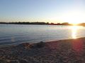
The sun setting over Lake Vlietland.


Achievements
FelixTheCat (talk) and Kat the Awesome earned the Land geohash achievement
|