Difference between revisions of "2020-07-25 51 6"
From Geohashing
m |
m |
||
| Line 31: | Line 31: | ||
| + | <!-- CATAGORIES --> | ||
[[Category:Expeditions]] | [[Category:Expeditions]] | ||
| + | [[Category:Geohashers|Trevil]] | ||
| + | [[Category:Geohashers|GeneralDuke]] | ||
| + | [[Category:Expeditions with photos]] | ||
| + | [[Category:Coordinates reached]] | ||
| + | |||
| + | <!-- | ||
| + | [[Category:Expedition planning]] | ||
| + | [[Category:Expeditions with videos]] | ||
| + | [[Category:Expedition without GPS]] | ||
| + | [[Category:Coordinates reached]] | ||
[[Category:Coordinates not reached]] | [[Category:Coordinates not reached]] | ||
| + | [[Category:Not reached - Did not attempt]] | ||
| + | [[Category:Not reached - Mother Nature]] | ||
[[Category:Not reached - No public access]] | [[Category:Not reached - No public access]] | ||
| − | + | [[Category:Not reached - Technology]] | |
| − | + | [[Category:Not reached - Time constraints]] | |
| − | + | [[Category:Not reached - Injury]] | |
| − | + | [[Category:Not reached - Attended alternate location]] | |
| − | |||
| − | |||
| − | |||
| − | |||
| − | |||
--> | --> | ||
| − | |||
| − | |||
| − | |||
Revision as of 13:18, 26 July 2020
| Sat 25 Jul 2020 in 51,6: 51.7735488, 6.0730584 geohashing.info google osm bing/os kml crox |
Location
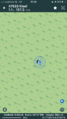
In the forests west of Kleve.
Participants
Trevil (talk)
GeneralDuke (talk)
Plans
I (Trevil) will be in and around Nijmegen on the 25th. So maybe I will take a small detour to the forests near Kleve and pick up this hash. And maybe i will bring a friend!
Expedition
Trevil's Log
After taking a 14 mile hike around Nijmegen, I had some time to kill. This hash in the woods west of Kleve was an oppertunity I could not let go. Luckily I was already in the company of GeneralDuke and we set off by car towards the German border. After a small drive we could park about 5 minutes walk away from the hash. The thick undergrowth and brambles were a bit of a nuisance but we managed.
Photos
Proof of GeneralDuke (talk)
