Difference between revisions of "2020-07-30 50 8"
From Geohashing
(Created page with "{{subst:Expedition |lat = 50 |lon = 8 |date = 2020-07-30 }}") |
|||
| Line 1: | Line 1: | ||
| − | + | {{meetup graticule | |
| − | |||
| − | |||
| − | |||
| − | |||
| − | |||
| − | |||
| − | |||
| − | |||
| lat=50 | | lat=50 | ||
| lon=8 | | lon=8 | ||
| Line 14: | Line 6: | ||
__NOTOC__ | __NOTOC__ | ||
== Location == | == Location == | ||
| − | + | In the woods not far from our home. | |
== Participants == | == Participants == | ||
| − | + | * [[User:Mampfred|Mampfred]] | |
| − | |||
== Plans == | == Plans == | ||
| − | + | Geohash droid helpfully reminded me yesterday that this hash is only 3.81km from my home. Also we have a fairly new e-bike in the garage that needs to be moved so ... win-win. | |
== Expedition == | == Expedition == | ||
| − | + | Started at 7:15 before work, e-biked my way through the forests in the Taunus and found the hash almost too easy just 30 meters into the woods off the tracks. Back at 8:05 for a shower followed by work, yay! | |
== Tracklog == | == Tracklog == | ||
| − | + | Used runtastic to track the ride and while I remembered that you can actually export GPX logs ... you can't anymore. Guess I have to get a new tracking app now, thanks Adidas. | |
== Photos == | == Photos == | ||
| − | |||
| − | |||
| − | |||
<gallery perrow="5"> | <gallery perrow="5"> | ||
| + | Image:2020-07-30 50 8 looking at the hash.jpg | Looking at the hash over the bike | ||
| + | Image:2020-07-30 50 8 coordinates reached.png | Coordinates reached | ||
| + | Image:2020-07-3050 8 the hash.jpg | The hash | ||
| + | Image:2020-07-30 50 8 stupid grin.jpg | Stupid grin | ||
| + | Image:2020-07-30 50 8 tracklog sortof.jpg | Closest thing to a tracklog | ||
</gallery> | </gallery> | ||
== Achievements == | == Achievements == | ||
{{#vardefine:ribbonwidth|800px}} | {{#vardefine:ribbonwidth|800px}} | ||
| − | + | {{Bicycle geohash | |
| − | + | | latitude = 50 | |
| − | + | | longitude = 8 | |
| − | + | | date = 2020-07-30 | |
| − | + | | name = Mampfred | |
| − | + | }} | |
| − | |||
| − | |||
| − | |||
| − | |||
| − | |||
| − | |||
| − | |||
| − | |||
[[Category:Expeditions]] | [[Category:Expeditions]] | ||
| − | |||
[[Category:Expeditions with photos]] | [[Category:Expeditions with photos]] | ||
| − | |||
| − | |||
| − | |||
| − | |||
| − | |||
[[Category:Coordinates reached]] | [[Category:Coordinates reached]] | ||
| − | |||
| − | |||
| − | |||
| − | |||
| − | |||
| − | |||
| − | |||
| − | |||
| − | |||
| − | |||
| − | |||
| − | |||
| − | |||
| − | |||
| − | |||
| − | |||
| − | |||
| − | |||
Revision as of 07:06, 30 July 2020
| Thu 30 Jul 2020 in 50,8: 50.2030718, 8.3700421 geohashing.info google osm bing/os kml crox |
Location
In the woods not far from our home.
Participants
Plans
Geohash droid helpfully reminded me yesterday that this hash is only 3.81km from my home. Also we have a fairly new e-bike in the garage that needs to be moved so ... win-win.
Expedition
Started at 7:15 before work, e-biked my way through the forests in the Taunus and found the hash almost too easy just 30 meters into the woods off the tracks. Back at 8:05 for a shower followed by work, yay!
Tracklog
Used runtastic to track the ride and while I remembered that you can actually export GPX logs ... you can't anymore. Guess I have to get a new tracking app now, thanks Adidas.
Photos
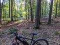
Looking at the hash over the bike

Coordinates reached
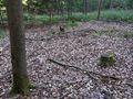
The hash

Stupid grin
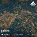
Closest thing to a tracklog


Achievements
Mampfred earned the Bicycle geohash achievement
|