Difference between revisions of "2020-08-11 49 8"
([live picture]Te R Ton achievement proof) |
|||
| Line 1: | Line 1: | ||
| − | + | {{meetup graticule | |
| − | |||
| − | |||
| − | |||
| − | |||
| − | |||
| − | |||
| − | |||
| − | |||
| lat=49 | | lat=49 | ||
| lon=8 | | lon=8 | ||
| date=2020-08-11 | | date=2020-08-11 | ||
| − | }} | + | }} |
| + | |||
__NOTOC__ | __NOTOC__ | ||
| + | |||
== Location == | == Location == | ||
<!-- where you've surveyed the hash to be --> | <!-- where you've surveyed the hash to be --> | ||
| + | In the middle of an apple and plum orchard. | ||
== Participants == | == Participants == | ||
<!-- who attended: If you link to your wiki user name in this section, your expedition will be picked up by the various statistics generated for geohashing. You may use three tildes ~ as a shortcut to automatically insert the user signature of the account you are editing with. | <!-- who attended: If you link to your wiki user name in this section, your expedition will be picked up by the various statistics generated for geohashing. You may use three tildes ~ as a shortcut to automatically insert the user signature of the account you are editing with. | ||
--> | --> | ||
| + | * [[User:Lyrla|Lyrla]] | ||
== Plans == | == Plans == | ||
<!-- what were the original plans --> | <!-- what were the original plans --> | ||
| + | Go there ~33km by bike and receive the tron achievement by choosing a different path back. | ||
== Expedition == | == Expedition == | ||
<!-- how it all turned out. your narrative goes here. --> | <!-- how it all turned out. your narrative goes here. --> | ||
| + | This journey was all about being wet. This was a really hot summer day with a peak around 35°C, so I started in the evening, but it still was 32°C when I started. I went by bike and had to go uphill from the very beginning. So when I reached the hash I was completely wet from sweat. | ||
| + | |||
| + | When I reached it, I realized that I am on top of a hill with noone around and remembered that I read something about a geoflashing achievement, so I went for it. I regretted that decision when I had to put my soaking wet shirt back on. | ||
| + | |||
| + | On my way up I saw some lightnings and heard some thunder, but it was really far away (24 seconds between lightning and thunder -> ~8km). But during my stay at the hash the thunderstorm snuck really close without me realizing it. And shortly after my departure it started raining. | ||
| − | + | I rushed downhill and when I got home, it was really close (only 4 seconds between lightning and thunder -> ~1,3km). I was wet again from top to toe. Nice way of cooling down on summer days, if it wasn't for the lightning. | |
| − | + | But it was worth anyways. I enjoyed that trip, and I started achievement-hunting on my second hash. | |
== Photos == | == Photos == | ||
| Line 43: | Line 45: | ||
Image:2020-08-11_49_8_Lyrla_1597181259730.jpg|Geoflashing proof | Image:2020-08-11_49_8_Lyrla_1597181259730.jpg|Geoflashing proof | ||
| − | Image:2020-08-11_49_8_Lyrla_1597182072588.jpg| | + | Image:2020-08-11_49_8_Lyrla_1597182072588.jpg|Tron achievement proof |
| − | + | ||
| − | |||
</gallery> | </gallery> | ||
| Line 51: | Line 52: | ||
{{#vardefine:ribbonwidth|800px}} | {{#vardefine:ribbonwidth|800px}} | ||
<!-- Add any achievement ribbons you earned below, or remove this section --> | <!-- Add any achievement ribbons you earned below, or remove this section --> | ||
| + | {{#vardefine:ribbonwidth|800px}} | ||
| + | {{Land geohash | ||
| + | | latitude = 49 | ||
| + | | longitude = 8 | ||
| + | | date = 2020-08-11 | ||
| + | | name = [[User:Lyrla|Lyrla]] | ||
| + | }} | ||
| + | {{bicycle geohash | ||
| + | | latitude = 49 | ||
| + | | longitude = 8 | ||
| + | | date = 2020-08-11 | ||
| + | | name = [[User:Lyrla|Lyrla]] | ||
| + | | distance = 33km | ||
| + | | bothways = true | ||
| + | }} | ||
| + | {{Tron | ||
| + | | latitude = 49 | ||
| + | | longitude = 8 | ||
| + | | date = 2020-08-11 | ||
| + | | tracklog = https://geohashing.site/geohashing/File:2020-08-11_49_8_Lyrla_1597182072588.jpg | ||
| + | | possessive = his | ||
| + | | name = [[User:Lyrla|Lyrla]] | ||
| + | }} | ||
| + | {{Geoflashing | ||
| + | | latitude = 49 | ||
| + | | longitude = 8 | ||
| + | | date = 2020-08-11 | ||
| + | | name = [[User:Lyrla|Lyrla]] | ||
| + | | image = https://geohashing.site/geohashing/File:2020-08-11_49_8_Lyrla_1597181259730.jpg | ||
| + | }} | ||
| − | |||
| − | |||
| − | |||
| − | |||
| − | |||
| − | |||
| − | |||
| − | |||
| − | |||
| − | |||
[[Category:Expeditions]] | [[Category:Expeditions]] | ||
| − | |||
[[Category:Expeditions with photos]] | [[Category:Expeditions with photos]] | ||
| − | |||
| − | |||
| − | |||
| − | |||
| − | |||
[[Category:Coordinates reached]] | [[Category:Coordinates reached]] | ||
| − | + | {{location|DE|RP|MZ|city=true}} | |
| − | + | {{location|DE|RP|MZ}} | |
| − | |||
| − | |||
| − | |||
| − | |||
| − | |||
| − | |||
| − | |||
| − | |||
| − | |||
| − | |||
| − | |||
| − | |||
| − | |||
| − | |||
| − | |||
| − | |||
Revision as of 22:17, 11 August 2020
| Tue 11 Aug 2020 in 49,8: 49.9703874, 8.1050841 geohashing.info google osm bing/os kml crox |
Location
In the middle of an apple and plum orchard.
Participants
Plans
Go there ~33km by bike and receive the tron achievement by choosing a different path back.
Expedition
This journey was all about being wet. This was a really hot summer day with a peak around 35°C, so I started in the evening, but it still was 32°C when I started. I went by bike and had to go uphill from the very beginning. So when I reached the hash I was completely wet from sweat.
When I reached it, I realized that I am on top of a hill with noone around and remembered that I read something about a geoflashing achievement, so I went for it. I regretted that decision when I had to put my soaking wet shirt back on.
On my way up I saw some lightnings and heard some thunder, but it was really far away (24 seconds between lightning and thunder -> ~8km). But during my stay at the hash the thunderstorm snuck really close without me realizing it. And shortly after my departure it started raining.
I rushed downhill and when I got home, it was really close (only 4 seconds between lightning and thunder -> ~1,3km). I was wet again from top to toe. Nice way of cooling down on summer days, if it wasn't for the lightning. But it was worth anyways. I enjoyed that trip, and I started achievement-hunting on my second hash.
Photos
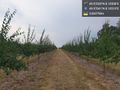
Plums @49.9704,8.1051

Goal reached
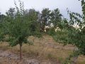
Goal
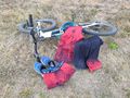
Geoflashing proof
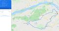
Tron achievement proof


Achievements
Lyrla earned the Land geohash achievement
|
Lyrla earned the Bicycle geohash achievement
|
Lyrla earned the Tron achievement
|
Lyrla earned the Geoflashing Achievement
|