Difference between revisions of "2020-08-24 48 7"
(Created page with "{{meetup graticule | lat = 48 | lon = 7 | date = 2020-08-24 }} == Location == In a wood, 200 meters outside Umkirch. == Participants == Baarde == Exped...") |
(→Achievements: Update bicycle distance) |
||
| (6 intermediate revisions by 2 users not shown) | |||
| Line 5: | Line 5: | ||
}} | }} | ||
== Location == | == Location == | ||
| − | In a wood, 200 meters outside Umkirch. | + | In a wood, 200 meters outside [[wikipedia:Umkirch|Umkirch]]. |
== Participants == | == Participants == | ||
| − | [[User:Baarde|Baarde]] | + | * [[User:Baarde|Baarde]] |
== Expedition == | == Expedition == | ||
| − | I | + | I was a somewhat hesitant about attempting this expedition as I was feeling a little unwell in the morning. Nonetheless, I took my bicycle, left home at 13:20 and went on what would be a very nice expedition with an ideal weather. I crossed the German border on the Sasbach-Marckolsheim bridge, took the direct route through the Kaiserstuhl hills and reached Umkrich in slightly less than two hours. |
| + | |||
| + | The coordinates were located in a small wood just outside the town. I took a couple photos and went to a nearby (but not [[Pub Geohash|within sight]]) establishment to have a beer, a coffee and a piece of rhubarb cake. | ||
| + | |||
| + | Then I cycled to Breisach am Rhein and climbed to the top of the Münsterberg hill before crossing the Rhine again and heading back home. | ||
== Photos == | == Photos == | ||
| − | <gallery | + | <gallery> |
| + | Image:2020-08-24 48 7 01.jpg | Heading towards Germany | ||
| + | Image:2020-08-24 48 7 02.jpg | Crossing the Rhine | ||
| + | Image:2020-08-24 48 7 03.jpg | Arriving in Umkirch | ||
| + | Image:2020-08-24 48 7 04.jpg | That path leads to the coordinates | ||
| + | Image:2020-08-24 48 7 06.png | Coordinates reached | ||
| + | Image:2020-08-24 48 7 05.jpg | Stupid grin | ||
| + | Image:2020-08-24 48 7 07.jpg | Cycling to Breisach | ||
| + | Image:2020-08-24 48 7 08.jpg | The view from Breisach | ||
</gallery> | </gallery> | ||
== Achievements == | == Achievements == | ||
| − | {{#vardefine:ribbonwidth| | + | {{#vardefine:ribbonwidth|100%}} |
{{land geohash | {{land geohash | ||
| latitude = 48 | | latitude = 48 | ||
| Line 30: | Line 42: | ||
| date = 2020-08-24 | | date = 2020-08-24 | ||
| name = [[User:Baarde|Baarde]] | | name = [[User:Baarde|Baarde]] | ||
| + | | distance = 98 km | ||
| + | | bothways = true | ||
}} | }} | ||
{{Border geohash achievement | {{Border geohash achievement | ||
| Line 42: | Line 56: | ||
__NOTOC__ | __NOTOC__ | ||
[[Category:Expeditions]] | [[Category:Expeditions]] | ||
| + | [[Category:Expeditions with photos]] | ||
[[Category:Coordinates reached]] | [[Category:Coordinates reached]] | ||
| + | {{location|DE|BW|FR}} | ||
Latest revision as of 11:20, 16 August 2021
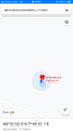
| Mon 24 Aug 2020 in 48,7: 48.0340621, 7.7758476 geohashing.info google osm bing/os kml crox |
Location
In a wood, 200 meters outside Umkirch.
Participants
Expedition
I was a somewhat hesitant about attempting this expedition as I was feeling a little unwell in the morning. Nonetheless, I took my bicycle, left home at 13:20 and went on what would be a very nice expedition with an ideal weather. I crossed the German border on the Sasbach-Marckolsheim bridge, took the direct route through the Kaiserstuhl hills and reached Umkrich in slightly less than two hours.
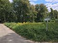
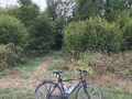
The coordinates were located in a small wood just outside the town. I took a couple photos and went to a nearby (but not within sight) establishment to have a beer, a coffee and a piece of rhubarb cake.
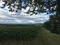
Then I cycled to Breisach am Rhein and climbed to the top of the Münsterberg hill before crossing the Rhine again and heading back home.
Photos
Heading towards Germany
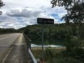
Crossing the Rhine
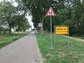
Arriving in Umkirch
That path leads to the coordinates
Coordinates reached
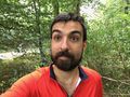
Stupid grin
Cycling to Breisach
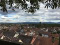
The view from Breisach


Achievements
Baarde earned the Land geohash achievement
|
Baarde earned the Bicycle geohash achievement
|
Baarde earned the Border geohash achievement
|