Difference between revisions of "2020-08-28 48 7"
(→Achievements: Remove consecutive (current record is 3)) |
|||
| (6 intermediate revisions by the same user not shown) | |||
| Line 5: | Line 5: | ||
}} | }} | ||
== Location == | == Location == | ||
| − | On a farm track, in Sélestat. | + | On a farm track, in [[wikipedia:Sélestat|Sélestat]]. |
== Participants == | == Participants == | ||
| Line 15: | Line 15: | ||
So I asked my dad to drive me to Sélestat and stayed at his office until the rain stopped. Then I walked the 2.5 remaining kilometers to the coordinates. | So I asked my dad to drive me to Sélestat and stayed at his office until the rain stopped. Then I walked the 2.5 remaining kilometers to the coordinates. | ||
| − | + | === Déjà vu: 2009-10-10 === | |
| + | [[File:2020-08-28 48 7 deja vu.png|330px|thumb|Déjà vu: 2009-10-10]] | ||
| + | |||
| + | I lived for 7 years in Sélestat and regularly goes here to visit friends and family. Had I already been on that very specific path? Yes, I had. The geohash is located just 10 meters from the route I took during [https://runkeeper.com/user/Baarde/activity/2865249 an evening run on 2009-10-10]. I remember that run vividly because it happened the day before the Sélestat 2009 10K race, which I wanted to take part in. However, due to bad planning I had not been able to register and had therefore decided to run the race's route (or something resembling it) on my own, before everyone else, with a headlamp. I took a wrong turn, ended up on this path by mistake and had to turn back after encountering a barrier (Don't ask me why there was a barrier there, I could barely see it). Conclusion: '''Bad planning leads to interesting stories.''' | ||
| + | |||
== Photos == | == Photos == | ||
| − | <gallery | + | <gallery> |
| + | Image:2020-08-28 48 7 01.jpg | Rue du Grand Muehlweg | ||
| + | Image:2020-08-28 48 7 02.jpg | Chemin du Grand Muehlweg | ||
| + | Image:2020-08-28 48 7 03.jpg | The location | ||
| + | Image:2020-08-28 48 7 04.png | Coordinates reached | ||
| + | Image:2020-08-28 48 7 05.jpg | Stupid grin | ||
</gallery> | </gallery> | ||
== Achievements == | == Achievements == | ||
| − | {{#vardefine:ribbonwidth| | + | {{#vardefine:ribbonwidth|100%}} |
| − | -- | + | {{land geohash |
| + | | latitude = 48 | ||
| + | | longitude = 7 | ||
| + | | date = 2020-08-28 | ||
| + | | name = [[User:Baarde|Baarde]] | ||
| + | }} | ||
| + | {{Déjà vu geohash | ||
| + | | latitude = 48 | ||
| + | | longitude = 7 | ||
| + | | date = 2020-08-28 | ||
| + | | name = [[User:Baarde|Baarde]] | ||
| + | | olddate = 2009-10-10 | ||
| + | }} | ||
__NOTOC__ | __NOTOC__ | ||
[[Category:Expeditions]] | [[Category:Expeditions]] | ||
| + | [[Category:Expeditions with photos]] | ||
[[Category:Coordinates reached]] | [[Category:Coordinates reached]] | ||
{{location|FR|67}} | {{location|FR|67}} | ||
Latest revision as of 08:29, 13 April 2023
| Fri 28 Aug 2020 in 48,7: 48.2732682, 7.4693970 geohashing.info google osm bing/os kml crox |
Location
On a farm track, in Sélestat.
Participants
Expedition
After looking at the weather forecast, I wasn’t very keen on attempting another Bicycle Geohash even though the coordinates were close from home and I could earn a Drowned Rat Geohash. Also I was expecting two phone calls in the afternoon.
So I asked my dad to drive me to Sélestat and stayed at his office until the rain stopped. Then I walked the 2.5 remaining kilometers to the coordinates.
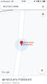
Déjà vu: 2009-10-10

I lived for 7 years in Sélestat and regularly goes here to visit friends and family. Had I already been on that very specific path? Yes, I had. The geohash is located just 10 meters from the route I took during an evening run on 2009-10-10. I remember that run vividly because it happened the day before the Sélestat 2009 10K race, which I wanted to take part in. However, due to bad planning I had not been able to register and had therefore decided to run the race's route (or something resembling it) on my own, before everyone else, with a headlamp. I took a wrong turn, ended up on this path by mistake and had to turn back after encountering a barrier (Don't ask me why there was a barrier there, I could barely see it). Conclusion: Bad planning leads to interesting stories.
Photos
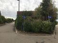
Rue du Grand Muehlweg
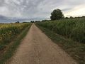
Chemin du Grand Muehlweg
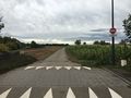
The location
Coordinates reached
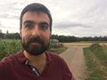
Stupid grin


Achievements
Baarde earned the Land geohash achievement
|
Baarde earned the Déjà Vu Geohash Achievement
|