Difference between revisions of "2020-08-30 1 103"
From Geohashing
([live] Reached the hashpoint at around 3.10pm currently sitting on a bench nearby.) |
(Update successful expedition) |
||
| Line 1: | Line 1: | ||
| − | + | {{meetup graticule | |
| − | |||
| − | |||
| − | |||
| − | |||
| − | |||
| − | |||
| − | |||
| − | |||
| lat=1 | | lat=1 | ||
| lon=103 | | lon=103 | ||
| date=2020-08-30 | | date=2020-08-30 | ||
| − | }} | + | }} |
__NOTOC__ | __NOTOC__ | ||
== Location == | == Location == | ||
| − | + | ||
| + | In Pasir Ris park, right on a park connector path near the northern end of the park. | ||
== Participants == | == Participants == | ||
| − | + | ||
| − | + | * [[User:Zertrin|Zertrin]] | |
| + | * [[User:Vermouthandgin|Vermouthandgin]] | ||
== Plans == | == Plans == | ||
<!-- what were the original plans --> | <!-- what were the original plans --> | ||
| + | Got the notification of a nice Sunday hash. Since we are currently stranded in Singapore for the foreseeable future because of COVID-related travel limitations, and that Pasir Ris is the other end of Singapore compared to where we live, I figured that this expedition could represent the best we can do to "travel" as far as possible short of crossing borders :-) | ||
| + | |||
| + | Only variable that could have derailed the expedition was the weather, but we got lucky with a nice hot Sunday afternoon without rain. | ||
== Expedition == | == Expedition == | ||
| Line 27: | Line 24: | ||
| − | *We're on our way to today's hashpoint in Pasir Ris park. Aiming to get there at around 3pm or a bit after. -- [[User:Zertrin|Zertrin]] ([[User talk:Zertrin|talk]]) 13:41, 30 August 2020 (GMT+08:00) | + | * We're on our way to today's hashpoint in Pasir Ris park. Aiming to get there at around 3pm or a bit after. -- [[User:Zertrin|Zertrin]] ([[User talk:Zertrin|talk]]) 13:41, 30 August 2020 (GMT+08:00) |
| − | *Reached the hashpoint at around 3.10pm currently sitting on a bench nearby. -- [[User:Zertrin|Zertrin]] ([[User talk:Zertrin|talk]]) 15:28, 30 August 2020 (GMT+08:00) | + | * Reached the hashpoint at around 3.10pm currently sitting on a bench nearby. -- [[User:Zertrin|Zertrin]] ([[User talk:Zertrin|talk]]) 15:28, 30 August 2020 (GMT+08:00) |
| − | + | ||
| − | + | * We left the bench as we began to feel hungry at around 3.45pm without having met any fellow geohasher and went back to Pasir Ris White Sands mall to have a very late lunch. [[User:Zertrin|Zertrin]] ([[User talk:Zertrin|talk]]) 11:55, 30 August 2020 (UTC) | |
== Photos == | == Photos == | ||
| Line 38: | Line 35: | ||
--> | --> | ||
<gallery perrow="5"> | <gallery perrow="5"> | ||
| − | |||
| − | |||
| − | |||
Image:2020-08-30_1_103_Zertrin_1598772240523.jpg|Hashpoint reached | Image:2020-08-30_1_103_Zertrin_1598772240523.jpg|Hashpoint reached | ||
Image:2020-08-30_1_103_Zertrin_1598772289260.jpg|Covid safe grin | Image:2020-08-30_1_103_Zertrin_1598772289260.jpg|Covid safe grin | ||
| + | |||
| + | Image:PANO_20200830_151444.jpg|Panorama of today's hashpoint in Parir Ris Park, Singapore | ||
</gallery> | </gallery> | ||
| Line 50: | Line 46: | ||
<!-- Add any achievement ribbons you earned below, or remove this section --> | <!-- Add any achievement ribbons you earned below, or remove this section --> | ||
| − | |||
| − | |||
| − | |||
| − | |||
| − | |||
| − | |||
| − | |||
| − | |||
| − | |||
| − | |||
| − | |||
| − | |||
| − | |||
[[Category:Expeditions]] | [[Category:Expeditions]] | ||
| − | + | [[Category:Expeditions with photos]] | |
| − | [[Category:Expeditions with photos]] | ||
| − | |||
| − | |||
| − | |||
| − | |||
| − | |||
[[Category:Coordinates reached]] | [[Category:Coordinates reached]] | ||
| − | |||
| − | |||
| − | |||
| − | |||
| − | |||
| − | |||
| − | |||
| − | |||
| − | |||
| − | |||
| − | |||
| − | |||
| − | |||
| − | |||
| − | |||
| − | |||
| − | |||
| − | |||
Revision as of 11:56, 30 August 2020
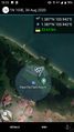
| Sun 30 Aug 2020 in 1,103: 1.3869381, 103.9421928 geohashing.info google osm bing/os kml crox |
Location
In Pasir Ris park, right on a park connector path near the northern end of the park.
Participants
Plans
Got the notification of a nice Sunday hash. Since we are currently stranded in Singapore for the foreseeable future because of COVID-related travel limitations, and that Pasir Ris is the other end of Singapore compared to where we live, I figured that this expedition could represent the best we can do to "travel" as far as possible short of crossing borders :-)
Only variable that could have derailed the expedition was the weather, but we got lucky with a nice hot Sunday afternoon without rain.
Expedition
- We're on our way to today's hashpoint in Pasir Ris park. Aiming to get there at around 3pm or a bit after. -- Zertrin (talk) 13:41, 30 August 2020 (GMT+08:00)
- Reached the hashpoint at around 3.10pm currently sitting on a bench nearby. -- Zertrin (talk) 15:28, 30 August 2020 (GMT+08:00)
- We left the bench as we began to feel hungry at around 3.45pm without having met any fellow geohasher and went back to Pasir Ris White Sands mall to have a very late lunch. Zertrin (talk) 11:55, 30 August 2020 (UTC)
Photos
Hashpoint reached

Covid safe grin

Panorama of today's hashpoint in Parir Ris Park, Singapore

