Difference between revisions of "2020-09-08 47 8"
(Photos) |
|||
| Line 38: | Line 38: | ||
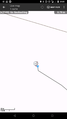
Image:2020-09-08_47_8_Tungmar_1599594345714.jpg| Close enough | Image:2020-09-08_47_8_Tungmar_1599594345714.jpg| Close enough | ||
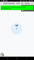
Image:2020-09-08 47 8 cgeo.png| Closest noted measure | Image:2020-09-08 47 8 cgeo.png| Closest noted measure | ||
| + | Image:2020-09-08 47 8 phone photo phone.jpeg| Old phone taking a photo of the new phone at the hash | ||
| + | Image:2020-09-08 47 8 view north.jpeg| View to north | ||
| + | Image:2020-09-08 47 8 view 300something.jpeg| 300something degree view | ||
</gallery> | </gallery> | ||
Revision as of 17:11, 9 September 2020
| Tue 8 Sep 2020 in 47,8: 47.2231625, 8.5673579 geohashing.info google osm bing/os kml crox |
Location
A grass field near Sihlbrugg.
Participants
Plans
Go to Sihlbrugg by public transport and walk up the hill.
Expedition
Finally my first GeoHash! I was watching the points for years but it was always to far for my lazy car-less ass. But today a spot was close by. Just a bit over a hour of train and bus ride plus half a hour walking (one way of course). Then it was in a beautiful valley on a fresh cut grass field. To easy so I added some GeoCaches in tunnels and on slippery hillsides.
While waiting for a good lock on the spot, some bikers passed by. They think I was searching for mice's or some thing as I didn't dear to explain...
It was a nice evening trip.
Tracklog
Photos
Close enough
Closest noted measure
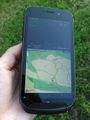
Old phone taking a photo of the new phone at the hash
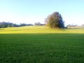
View to north
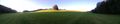
300something degree view


