Difference between revisions of "2020-09-17 45 4"
(→Achievements: Velociraptors) |
m (→Achievements: Update ribbon width) |
||
| (2 intermediate revisions by the same user not shown) | |||
| Line 5: | Line 5: | ||
}} | }} | ||
== Location == | == Location == | ||
| − | In a meadow near Saint-Romain-en-Gier. | + | In a meadow near [[wikipedia:Saint-Romain-en-Gier|Saint-Romain-en-Gier]]. |
== Participants == | == Participants == | ||
| Line 23: | Line 23: | ||
== Photos == | == Photos == | ||
| − | <gallery | + | <gallery> |
Image:2020-09-17 45 4 01.jpg | Arriving by train in Givors | Image:2020-09-17 45 4 01.jpg | Arriving by train in Givors | ||
Image:2020-09-17 45 4 02.jpg | Walking out of Givors toward Saint-Romain-en-Gier | Image:2020-09-17 45 4 02.jpg | Walking out of Givors toward Saint-Romain-en-Gier | ||
| Line 37: | Line 37: | ||
== Achievements == | == Achievements == | ||
| − | {{#vardefine:ribbonwidth| | + | {{#vardefine:ribbonwidth|100%}} |
{{land geohash | {{land geohash | ||
| latitude = 45 | | latitude = 45 | ||
Latest revision as of 15:39, 4 May 2021
| Thu 17 Sep 2020 in 45,4: 45.5733916, 4.7236349 geohashing.info google osm bing/os kml crox |
Location
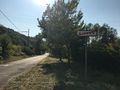
In a meadow near Saint-Romain-en-Gier.
Participants
Expedition
Having some business to attend in Lyon, France, I decided to move the graticule back in the Active graticules category. But without my bicycle I have to resort to taking the train and walking. Fortunately, today's coordinates were quite close (about 5km) to a train station.
After taking the 15:31 train to Givors, I walked along a street that runs for a few kilometers between the railway on one side and the Gier river and the A47 motorway on the other. Then I crossed a bridge above the railway and ventured into the forest. The path climbed a little bit up the foothills of the Pilat massif, crossed a dried-up stream and went down towards Saint-Romain-en-Gier.
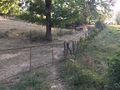
The access to the meadow containing the coordinates was blocked by an enclosed field, which I circumvented by walking through the woods.
On the geohash's location was a hay bale. Well, it might originally have been a little bit to the east, but I wasn't going to have my Stupid grin photo taken in front of a hay bale if I could have it taken on top of it. I managed to get a nice picture by sticking my phone on a nearby wooden fence post and using the 10-second self-timer (there also was a lot of running and jumping involved).
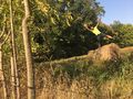
After putting everything back where it belonged, I noticed a path bellow the meadow, which continued towards Saint-Romain-en-Gier and would be flatter (though longer) than heading back on the route I had taken to come. I decided to follow it. That was a mistake. After a couple hundred meters I encountered a fence with no way around (I tried. Another mistake). Rather than retracing my steps, I took the path in the other direction (third mistake) which lead me through brambles to a dead-end. However, with the help of the All-Knowing Google and after a little bit of climbing, I finally managed to find my way back. It was during all that wandering that I was savagely attacked by Velociraptors.
Photos

Arriving by train in Givors
Walking out of Givors toward Saint-Romain-en-Gier
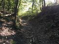
A little bit of climbing
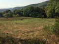
The coordinates are in this meadow.
Coordinates reached
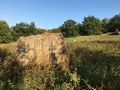
A geohash in a haystack

Stupid grin
I couldn't not do this.
Oops! Wrong path.
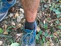
Aftermath of a Raptor attack


Achievements
Baarde earned the Land geohash achievement
|
Baarde earned the Velociraptor Geohash Achievement
|