Difference between revisions of "2020-10-11 50 8"
(Created page with "{{subst:Expedition |lat = 50 |lon = 8 |date = 2020-10-11 }}") |
Pedalpusher (talk | contribs) m (→Expedition: fixed some text) |
||
| (5 intermediate revisions by 2 users not shown) | |||
| Line 1: | Line 1: | ||
| − | + | {{meetup graticule | |
| − | |||
| − | |||
| − | |||
| − | |||
| − | |||
| − | |||
| − | |||
| − | |||
| lat=50 | | lat=50 | ||
| lon=8 | | lon=8 | ||
| Line 14: | Line 6: | ||
__NOTOC__ | __NOTOC__ | ||
== Location == | == Location == | ||
| − | + | On or next to the Bundesstrasse passing right next to the restaurant [https://waldgeist-xxl.de/ "Waldgeist zur eisernen Hand"]. | |
== Participants == | == Participants == | ||
| − | + | * [[User:QuarterCacher|QuarterCacher]] | |
| − | + | * [[User:M|M]] | |
| + | * [[User:LadyBB|LadyBB]] | ||
| + | * [[User:EmmJay|EmmJay]] | ||
| + | * [[User:Mampfred|Mampfred]] | ||
== Plans == | == Plans == | ||
| − | + | Go for a walk, do some geocaches as well as the hash, have lunch at the Waldgeist. | |
== Expedition == | == Expedition == | ||
| − | + | We met up at 12:20 and drove (one car, fully electric ;) to the hiking parking lot that was designated on google maps. There wasn't actually a parking lot but we parked on the side of the street anyway. | |
| + | |||
| + | Since we had another hour and a half until our reservation at the restaurant, we started out in the opposite direction and found a number of caches: | ||
| + | |||
| + | We finally headed back to the restaurant and had a lovely lunch with lots of "Schnitzels". After lunch, we finally headed for the hash which by then was a mere 200 meters walking distance (although walking wasn't quite the right term anymore after our lunch, some of us were rolling rather than walking). | ||
| + | |||
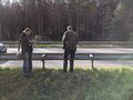
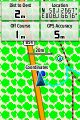
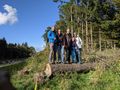
| + | The hash was right next to the Bundesstrasse as expected, however, we were quite lucky in that we found it to be on our side of the guard railing. We took a nice group shot and that was done as well. | ||
| − | + | Because we still weren't tired enough we did some more caches in the other direction before finally heading back home after a four and a half hour expedition. | |
| − | + | ||
| + | Geocaches visited: | ||
| + | * [https://coord.info/GC392BZ GC392BZ] - Not found | ||
| + | * [https://coord.info/GC392BN GC392BN] - Found | ||
| + | * [https://coord.info/GC392BA GC392BA] - Found | ||
| + | * [https://coord.info/GC392AY GC392AY] - Found | ||
| + | * [https://coord.info/GC3AY5A GC3AY5A] - Found | ||
| + | * [https://coord.info/GC38K7C GC38K7C] - Found | ||
| + | * [https://coord.info/GC4PQWE GC4PQWE] - Found | ||
| + | * [https://coord.info/GC3BRT3 GC3BRT3] - Found | ||
| + | * [https://coord.info/GC38K7B GC38K7B] - Found | ||
| + | * [https://coord.info/GC38K7D GC38K7D] - Found | ||
== Photos == | == Photos == | ||
| − | |||
| − | |||
| − | |||
<gallery perrow="5"> | <gallery perrow="5"> | ||
| + | Image:2020-10-11_50_8_hash_dance.jpg | Hash dance | ||
| + | Image:2020-10-11_50_8_coordinates_reached.jpg | Coordinates reached | ||
| + | Image:2020-10-11_50_8_group_grin.jpg | Group grin | ||
</gallery> | </gallery> | ||
| + | |||
| + | == Tracklog == | ||
| + | {{tracklog | 2020-10-11_50_8_tracklog.gpx}} | ||
== Achievements == | == Achievements == | ||
{{#vardefine:ribbonwidth|800px}} | {{#vardefine:ribbonwidth|800px}} | ||
| − | |||
| − | |||
| − | |||
| − | |||
| − | |||
| − | |||
| − | |||
| − | |||
| − | |||
| − | |||
| − | |||
| − | |||
| − | |||
| − | |||
| − | |||
| − | |||
[[Category:Expeditions]] | [[Category:Expeditions]] | ||
| − | |||
[[Category:Expeditions with photos]] | [[Category:Expeditions with photos]] | ||
| − | |||
| − | |||
| − | |||
| − | |||
| − | |||
[[Category:Coordinates reached]] | [[Category:Coordinates reached]] | ||
| − | + | {{location|DE|HE|SWA}} | |
| − | |||
| − | |||
| − | |||
| − | |||
| − | |||
| − | |||
| − | |||
| − | |||
| − | |||
| − | |||
| − | |||
| − | |||
| − | |||
| − | |||
| − | |||
| − | |||
| − | |||
Latest revision as of 21:07, 18 October 2020
| Sun 11 Oct 2020 in 50,8: 50.1266827, 8.1667367 geohashing.info google osm bing/os kml crox |
Location
On or next to the Bundesstrasse passing right next to the restaurant "Waldgeist zur eisernen Hand".
Participants
Plans
Go for a walk, do some geocaches as well as the hash, have lunch at the Waldgeist.
Expedition
We met up at 12:20 and drove (one car, fully electric ;) to the hiking parking lot that was designated on google maps. There wasn't actually a parking lot but we parked on the side of the street anyway.
Since we had another hour and a half until our reservation at the restaurant, we started out in the opposite direction and found a number of caches:
We finally headed back to the restaurant and had a lovely lunch with lots of "Schnitzels". After lunch, we finally headed for the hash which by then was a mere 200 meters walking distance (although walking wasn't quite the right term anymore after our lunch, some of us were rolling rather than walking).
The hash was right next to the Bundesstrasse as expected, however, we were quite lucky in that we found it to be on our side of the guard railing. We took a nice group shot and that was done as well.
Because we still weren't tired enough we did some more caches in the other direction before finally heading back home after a four and a half hour expedition.
Geocaches visited:
- GC392BZ - Not found
- GC392BN - Found
- GC392BA - Found
- GC392AY - Found
- GC3AY5A - Found
- GC38K7C - Found
- GC4PQWE - Found
- GC3BRT3 - Found
- GC38K7B - Found
- GC38K7D - Found
Photos
Hash dance
Coordinates reached
Group grin


Tracklog