Difference between revisions of "2020-10-28 45 4"
(Created page with "{{meetup graticule | lat = 45 | lon = 4 | date = 2020-10-28 }} == Location == Between a corn field and a fishing pond in Lapeyrouse. == Pa...") |
m (→Achievements: Update ribbon width) |
||
| (4 intermediate revisions by 2 users not shown) | |||
| Line 11: | Line 11: | ||
== Expedition == | == Expedition == | ||
| + | |||
| + | I took the train from Lyon to Villars-les-Dombes and started walking towards the geohash. After exiting Villars-les-Dombes, I left the road and took a detour through the fields in order to avoid the traffic. On my way, I passed several ponds and pools. The Dombes area has a very impervious surface and more than 10% of it is therefore covered by water. | ||
| + | |||
| + | After walking 6 km, I reached the ''Étang Rollet'' pond. There, a large tourist sign informed me about: | ||
| + | * its size: 26 hectares, | ||
| + | * its age: more than 500 years, | ||
| + | * and how to cook pike: with cream or court-bouillon, then served cold with mayonnaise. | ||
| + | |||
| + | The coordinates were 2 km further, in a small meadow between the pond and a corn field. After recording proof, I marched back to the train station. The sun was now in my back and intermittently lighting the autumn foliage trough the clouds. What a lovely day! | ||
== Photos == | == Photos == | ||
<gallery> | <gallery> | ||
| + | Image:2020-10-28 45 4 01.jpg | Villars-les-Dombes train station | ||
| + | Image:2020-10-28 45 4 02.jpg | A pond | ||
| + | Image:2020-10-28 45 4 04.jpg | Another pond | ||
| + | Image:2020-10-28 45 4 03.jpg | Tourist sign about pond | ||
| + | Image:2020-10-28 45 4 05.jpg | Almost to the coordinates | ||
| + | Image:2020-10-28 45 4 06.jpg | Yet another pond | ||
| + | Image:2020-10-28 45 4 07.png | Coordinates reached | ||
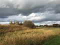
| + | Image:2020-10-28 45 4 08.jpg | Surroundings (north) | ||
| + | Image:2020-10-28 45 4 09.jpg | Surroundings (west) | ||
| + | Image:2020-10-28 45 4 10.jpg | Stupid grin | ||
| + | Image:2020-10-28 45 4 11.jpg | Autumn foliage | ||
| + | Image:2020-10-28 45 4 12.jpg | More autumn foliage | ||
</gallery> | </gallery> | ||
== Achievements == | == Achievements == | ||
| − | {{#vardefine:ribbonwidth| | + | {{#vardefine:ribbonwidth|100%}} |
| + | |||
| + | {{land geohash | ||
| + | | latitude = 45 | ||
| + | | longitude = 4 | ||
| + | | date = 2020-10-28 | ||
| + | | name = [[User:Baarde|Baarde]] | ||
| + | }} | ||
__NOTOC__ | __NOTOC__ | ||
[[Category:Expeditions]] | [[Category:Expeditions]] | ||
| + | [[Category:Expeditions with photos]] | ||
| + | [[Category:Coordinates reached]] | ||
| + | {{location|FR|01}} | ||
Latest revision as of 15:42, 4 May 2021
| Wed 28 Oct 2020 in 45,4: 45.9985600, 4.9550556 geohashing.info google osm bing/os kml crox |
Location
Between a corn field and a fishing pond in Lapeyrouse.
Participants
Expedition
I took the train from Lyon to Villars-les-Dombes and started walking towards the geohash. After exiting Villars-les-Dombes, I left the road and took a detour through the fields in order to avoid the traffic. On my way, I passed several ponds and pools. The Dombes area has a very impervious surface and more than 10% of it is therefore covered by water.
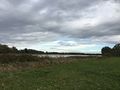
After walking 6 km, I reached the Étang Rollet pond. There, a large tourist sign informed me about:
- its size: 26 hectares,
- its age: more than 500 years,
- and how to cook pike: with cream or court-bouillon, then served cold with mayonnaise.
The coordinates were 2 km further, in a small meadow between the pond and a corn field. After recording proof, I marched back to the train station. The sun was now in my back and intermittently lighting the autumn foliage trough the clouds. What a lovely day!
Photos
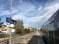
Villars-les-Dombes train station
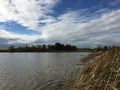
A pond
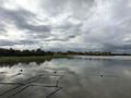
Another pond
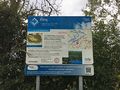
Tourist sign about pond
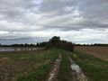
Almost to the coordinates
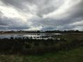
Yet another pond

Coordinates reached
Surroundings (north)
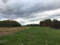
Surroundings (west)

Stupid grin
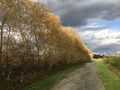
Autumn foliage
More autumn foliage


Achievements
Baarde earned the Land geohash achievement
|