Difference between revisions of "2020-11-01 51 4"
FelixTheCat (talk | contribs) (Created page with "{{subst:Expedition |lat = 51 |lon = 4 |date = 2020-11-01 }}") |
FelixTheCat (talk | contribs) |
||
| Line 1: | Line 1: | ||
| − | + | {{meetup graticule | |
| − | |||
| − | |||
| − | |||
| − | |||
| − | |||
| − | |||
| − | |||
| − | |||
| lat=51 | | lat=51 | ||
| lon=4 | | lon=4 | ||
| date=2020-11-01 | | date=2020-11-01 | ||
| − | }} | + | }} |
__NOTOC__ | __NOTOC__ | ||
== Location == | == Location == | ||
| − | + | Schipluiden, municipality of Midden-Delfland. | |
== Participants == | == Participants == | ||
| − | + | [[User:FelixTheCat|FelixTheCat]] ([[User talk:FelixTheCat|talk]]) | |
| − | |||
| − | |||
| − | |||
| − | |||
== Expedition == | == Expedition == | ||
| − | + | Today's hash in 51,4 was in the middle of a farmer's field. Normally such places are out of bounds, but this time the point was right next to a public footpath called ''Voddijkpad''. This is actually a very old footpath, dating to the mid-twelfth century, linking the villages of Schipluiden and 't Woudt. It was mainly in use as a [https://en.wikipedia.org/wiki/Mass_path mass path] (a footpath in rural areas that locals used to walk to church), so it was kind of appropriate to go there on a Sunday morning. I rode my bike to the beginning of the path, then walked along it for about 200 metres. I found the point quite easily and took a few photos. It then started to rain, so I walked back to my bike and rode home again. | |
| − | |||
| − | |||
| − | |||
== Photos == | == Photos == | ||
| − | |||
| − | |||
| − | |||
<gallery perrow="5"> | <gallery perrow="5"> | ||
| + | Image:2020-11-01 51 4 FelixTheCat 1.JPG | Arriving at the northern end of Schipluiden. The hash is somewhere in the field on the left. | ||
| + | Image:2020-11-01 51 4 FelixTheCat 2.JPG | The beginning of Voddijkpad. The path is located on farmers' private property, so it's not allowed to venture off into the fields. Luckily, the point is right next to the footpath. | ||
| + | Image:2020-11-01 51 4 FelixTheCat 3.JPG | An information display that's seen better days. | ||
| + | Image:2020-11-01 51 4 FelixTheCat 4.JPG | Walking along the path. There are little bridges to cross the many drainage ditches. | ||
| + | Image:2020-11-01 51 4 FelixTheCat 5.JPG | The remains of a red crayfish (''Procambarus clarkii''), an invasive species that's become very common in Dutch waters. | ||
| + | Image:2020-11-01 51 4 FelixTheCat 6.JPG | Looking at the hash point (a few metres ahead). | ||
| + | Image:2020-11-01 51 4 FelixTheCat 7.JPG | Standing on it. | ||
| + | Image:2020-11-01 51 4 FelixTheCat 8.png | GPS proof. | ||
| + | Image:2020-11-01 51 4 FelixTheCat 9.JPG | Lloyd celebrating another success. | ||
</gallery> | </gallery> | ||
== Achievements == | == Achievements == | ||
{{#vardefine:ribbonwidth|800px}} | {{#vardefine:ribbonwidth|800px}} | ||
| − | + | {{bicycle geohash | |
| + | | latitude = 51 | ||
| + | | longitude = 4 | ||
| + | | date = 2020-11-01 | ||
| + | | name = [[User:FelixTheCat|FelixTheCat]] ([[User talk:FelixTheCat|talk]]) | ||
| + | | distance = 12 km | ||
| + | | bothways = true | ||
| + | }} | ||
| − | |||
| − | |||
| − | |||
| − | |||
| − | |||
| − | |||
| − | |||
| − | |||
| − | |||
| − | |||
| − | |||
| − | |||
| − | |||
| − | |||
[[Category:Expeditions]] | [[Category:Expeditions]] | ||
| − | |||
[[Category:Expeditions with photos]] | [[Category:Expeditions with photos]] | ||
| − | |||
| − | |||
| − | |||
| − | |||
| − | |||
[[Category:Coordinates reached]] | [[Category:Coordinates reached]] | ||
| − | |||
| − | |||
| − | |||
| − | |||
| − | |||
| − | |||
| − | |||
| − | |||
| − | |||
| − | |||
| − | |||
| − | |||
| − | |||
| − | |||
| − | |||
| − | |||
| − | |||
| − | |||
Revision as of 12:52, 1 November 2020
| Sun 1 Nov 2020 in 51,4: 51.9914429, 4.3033575 geohashing.info google osm bing/os kml crox |
Location
Schipluiden, municipality of Midden-Delfland.
Participants
Expedition
Today's hash in 51,4 was in the middle of a farmer's field. Normally such places are out of bounds, but this time the point was right next to a public footpath called Voddijkpad. This is actually a very old footpath, dating to the mid-twelfth century, linking the villages of Schipluiden and 't Woudt. It was mainly in use as a mass path (a footpath in rural areas that locals used to walk to church), so it was kind of appropriate to go there on a Sunday morning. I rode my bike to the beginning of the path, then walked along it for about 200 metres. I found the point quite easily and took a few photos. It then started to rain, so I walked back to my bike and rode home again.
Photos
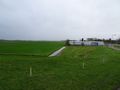
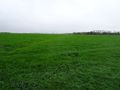
Arriving at the northern end of Schipluiden. The hash is somewhere in the field on the left.
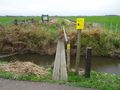
The beginning of Voddijkpad. The path is located on farmers' private property, so it's not allowed to venture off into the fields. Luckily, the point is right next to the footpath.
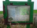
An information display that's seen better days.
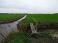
Walking along the path. There are little bridges to cross the many drainage ditches.
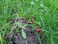
The remains of a red crayfish (Procambarus clarkii), an invasive species that's become very common in Dutch waters.
Looking at the hash point (a few metres ahead).
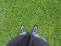
Standing on it.
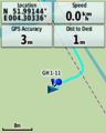
GPS proof.
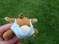
Lloyd celebrating another success.


Achievements
FelixTheCat (talk) earned the Bicycle geohash achievement
|