Difference between revisions of "2020-11-03 50 9"
(Report!) |
|||
| Line 18: | Line 18: | ||
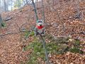
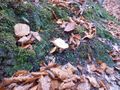
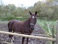
After visiting the [[2020-11-03 50 12|50 12]] spot, I drove along the autobahn A4 and 240 km later I reached the Friedewald exit. I followed a federal road, then turned into a smaller road and reached the hamlet Schenksolz. There I parked the car next to a riding center and started walking along a track and past horse pastures towards the spot. After a few minutes I stood next to a steep decline. Very carefully I climbed down until I was within a few meters of the spot, then a complicated hashdance followed. As the incline was about 40°, each step had to be very careful because I didn't want to fall down and slide through the dirt to the bottom. I had to climb in a circle twice before I reached the spot. After taking the usual pictures, I climbed back to the track and walked to the car. Then I drove along the country road to Bad Hersfeld and back to the autobahn. | After visiting the [[2020-11-03 50 12|50 12]] spot, I drove along the autobahn A4 and 240 km later I reached the Friedewald exit. I followed a federal road, then turned into a smaller road and reached the hamlet Schenksolz. There I parked the car next to a riding center and started walking along a track and past horse pastures towards the spot. After a few minutes I stood next to a steep decline. Very carefully I climbed down until I was within a few meters of the spot, then a complicated hashdance followed. As the incline was about 40°, each step had to be very careful because I didn't want to fall down and slide through the dirt to the bottom. I had to climb in a circle twice before I reached the spot. After taking the usual pictures, I climbed back to the track and walked to the car. Then I drove along the country road to Bad Hersfeld and back to the autobahn. | ||
| − | |||
| − | |||
<gallery> | <gallery> | ||
Revision as of 16:28, 5 November 2020
| Tue 3 Nov 2020 in Fulda: 50.8403587, 9.8357783 geohashing.info google osm bing/os kml crox |
Location
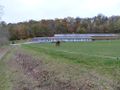
Today's location is on a steep hillside at Schenklengsfeld-Schenksolz, not far from Bad Hersfeld.
Country: Germany; state: Hessen (EU:DE:HE); Regierungsbezirk: Kassel; district: Hersfeld-Rotenburg
Expedition
Danatar
After visiting the 50 12 spot, I drove along the autobahn A4 and 240 km later I reached the Friedewald exit. I followed a federal road, then turned into a smaller road and reached the hamlet Schenksolz. There I parked the car next to a riding center and started walking along a track and past horse pastures towards the spot. After a few minutes I stood next to a steep decline. Very carefully I climbed down until I was within a few meters of the spot, then a complicated hashdance followed. As the incline was about 40°, each step had to be very careful because I didn't want to fall down and slide through the dirt to the bottom. I had to climb in a circle twice before I reached the spot. After taking the usual pictures, I climbed back to the track and walked to the car. Then I drove along the country road to Bad Hersfeld and back to the autobahn.
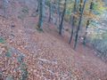
almost there
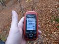
GPS

coordinates reached

panorama


tracklog
will follow