Difference between revisions of "2020-11-10 62 29"
(Created page with "{{subst:Expedition}}") |
|||
| (2 intermediate revisions by 2 users not shown) | |||
| Line 1: | Line 1: | ||
| − | + | {{meetup graticule | |
| − | |||
| − | |||
| − | |||
| − | |||
| − | |||
| − | |||
| − | |||
| − | |||
| lat={{#explode:{{SUBPAGENAME}}| |1}} | | lat={{#explode:{{SUBPAGENAME}}| |1}} | ||
| lon={{#explode:{{SUBPAGENAME}}| |2}} | | lon={{#explode:{{SUBPAGENAME}}| |2}} | ||
| date={{#explode:{{SUBPAGENAME}}| |0}} | | date={{#explode:{{SUBPAGENAME}}| |0}} | ||
| − | }} | + | }} |
__NOTOC__ | __NOTOC__ | ||
== Location == | == Location == | ||
| − | + | On a hillock near the motocross circuit in Uuro, Kontiolahti. | |
| + | |||
| + | The point on a topographic map: [https://asiointi.maanmittauslaitos.fi/karttapaikka/?lang=en&share=customMarker&n=6957574.8&e=646780.0&title=Geohash+2020-11-10+62+29&desc=&zoom=10] | ||
== Participants == | == Participants == | ||
| − | + | * [[User:Kripakko|Kripakko]] | |
| − | + | ||
| + | == Expedition == | ||
| + | I finally got a hashpoint that was in an accessible place reasonably close to my home. I wanted to make use of the little available daylight: we are already so close to winter solstice that days are very short (seven hours from sunrise to sunset). I left for the hashpoint at about quarter past one so that I would be back before dusk. Thankfully, the sun was shining in an almost cloudless sky, something that rarely happens in autumn, so it was enjoyable to be outside. | ||
| − | + | The temperature outside was slightly freezing. Much of the roads and grass that I saw were covered in thin frost, and small vegetation was frozen. It was nice to cycle though because there was no slippery ice anywhere except for some frozen puddles that were easy to avoid. Winter is coming little by little, and I am already eagerly awaiting constant freeze and plenty of snow. | |
| − | |||
| − | + | The hashpoint was located on a dry hillock surrounded by a swamp that was frozen and easy to traverse. The surrounding forest was quite uninteresting, but I did get an enjoyable surprise in lingonberries (''Vaccinium vitis-idaea'') that had frozen and melted several times. I like them best that way, and they are even better when picked in spring under melting snow. Also this time, I brought a thermometer to prove the temperature which, after long stabilisation, was −1 °C. | |
| − | |||
| − | + | I was back at home at half past three, just after sunset. The total cycling distance was 26.3 kilometres, and I had to walk about 350 metres. | |
| − | |||
== Photos == | == Photos == | ||
| − | < | + | <gallery perrow="6"> |
| − | Image:2020- | + | Image:2020-11-10_62_29_01-moon.jpg | The crescent moon in the sky. |
| − | -- | + | Image:2020-11-10_62_29_02-road.jpg | Road and grass covered in thin frost near Lehmo sports centre. |
| − | + | Image:2020-11-10_62_29_03-sign.jpg | The sign of the motocross circuit. | |
| + | Image:2020-11-10_62_29_04-puddle.jpg | The bicycle standing on a frozen puddle. | ||
| + | Image:2020-11-10_62_29_05-bicycle.jpg | The bicycle parked at the roadside, 170 metres to go. | ||
| + | Image:2020-11-10_62_29_06-hashpoint.jpg | Forest at the hashpoint, some very typical East Finnish taiga. | ||
| + | Image:2020-11-10_62_29_07-lingonberry.jpg | Lingonberries are most delicious after having frozen a few times. | ||
| + | Image:2020-11-10_62_29_08-gpsr1.jpg | Proof of location. | ||
| + | Image:2020-11-10_62_29_09-gpsr2.jpg | Proof of time and date. | ||
| + | Image:2020-11-10_62_29_10-thermometer.jpg | Proof of temperature. | ||
| + | Image:2020-11-10_62_29_11-sunset.jpg | 25 minutes to sunset. | ||
</gallery> | </gallery> | ||
== Achievements == | == Achievements == | ||
{{#vardefine:ribbonwidth|800px}} | {{#vardefine:ribbonwidth|800px}} | ||
| − | + | {{land geohash | latitude = 62 | longitude = 29 | date = 2020-11-10 | name = Kripakko }} | |
| + | {{bicycle geohash | latitude = 62 | longitude = 29 | date = 2020-11-10 | name = Kripakko | distance = 26.3 km | bothways = true }} | ||
| + | {{Frozen Geohash | latitude = 62 | longitude = 29 | date = 2020-11-10 | name = Kripakko | temperature = −1 °C }} | ||
| − | |||
| − | |||
| − | |||
| − | |||
| − | |||
| − | |||
| − | |||
| − | |||
| − | |||
| − | |||
| − | |||
| − | |||
| − | |||
| − | |||
[[Category:Expeditions]] | [[Category:Expeditions]] | ||
| − | |||
[[Category:Expeditions with photos]] | [[Category:Expeditions with photos]] | ||
| − | |||
| − | |||
| − | |||
| − | |||
| − | |||
[[Category:Coordinates reached]] | [[Category:Coordinates reached]] | ||
| − | + | {{location|FI|13}} | |
| − | |||
| − | |||
| − | |||
| − | |||
| − | |||
| − | |||
| − | |||
| − | |||
| − | |||
| − | |||
| − | |||
| − | |||
| − | |||
| − | |||
| − | |||
| − | |||
| − | |||
Latest revision as of 21:02, 11 November 2020
| Tue 10 Nov 2020 in 62,29: 62.7192137, 29.8709436 geohashing.info google osm bing/os kml crox |
Location
On a hillock near the motocross circuit in Uuro, Kontiolahti.
The point on a topographic map: [1]
Participants
Expedition
I finally got a hashpoint that was in an accessible place reasonably close to my home. I wanted to make use of the little available daylight: we are already so close to winter solstice that days are very short (seven hours from sunrise to sunset). I left for the hashpoint at about quarter past one so that I would be back before dusk. Thankfully, the sun was shining in an almost cloudless sky, something that rarely happens in autumn, so it was enjoyable to be outside.
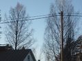
The temperature outside was slightly freezing. Much of the roads and grass that I saw were covered in thin frost, and small vegetation was frozen. It was nice to cycle though because there was no slippery ice anywhere except for some frozen puddles that were easy to avoid. Winter is coming little by little, and I am already eagerly awaiting constant freeze and plenty of snow.
The hashpoint was located on a dry hillock surrounded by a swamp that was frozen and easy to traverse. The surrounding forest was quite uninteresting, but I did get an enjoyable surprise in lingonberries (Vaccinium vitis-idaea) that had frozen and melted several times. I like them best that way, and they are even better when picked in spring under melting snow. Also this time, I brought a thermometer to prove the temperature which, after long stabilisation, was −1 °C.
I was back at home at half past three, just after sunset. The total cycling distance was 26.3 kilometres, and I had to walk about 350 metres.
Photos
The crescent moon in the sky.
Road and grass covered in thin frost near Lehmo sports centre.
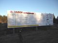
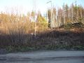
The sign of the motocross circuit.
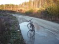
The bicycle standing on a frozen puddle.
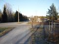
The bicycle parked at the roadside, 170 metres to go.
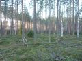
Forest at the hashpoint, some very typical East Finnish taiga.
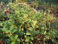
Lingonberries are most delicious after having frozen a few times.
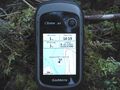
Proof of location.
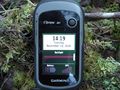
Proof of time and date.
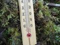
Proof of temperature.
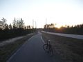
25 minutes to sunset.


Achievements
Kripakko earned the Land geohash achievement
|
Kripakko earned the Bicycle geohash achievement
|
