Difference between revisions of "2020-12-13 47 8"
([retro] Visited the a bit awkward but easy to reach hash.) |
(→Photos) |
||
| (7 intermediate revisions by 3 users not shown) | |||
| Line 1: | Line 1: | ||
| − | + | {{meetup graticule | |
| − | |||
| − | |||
| − | |||
| − | |||
| − | |||
| − | |||
| − | |||
| − | |||
| lat=47 | | lat=47 | ||
| lon=8 | | lon=8 | ||
| date=2020-12-13 | | date=2020-12-13 | ||
| − | }} | + | }} |
| + | |||
__NOTOC__ | __NOTOC__ | ||
== Location == | == Location == | ||
| − | + | On a small patch of grass on the side of a house at the Langgrütstrasse in Zürich, Switzerland, Earth. | |
== Participants == | == Participants == | ||
| − | + | * [[User:Tungmar|Tungmar]] | |
| − | |||
== Plans == | == Plans == | ||
| − | + | Go there and see if it is accessible. | |
== Expedition == | == Expedition == | ||
| − | + | I did a walk in the city and after the hash on the Uetlihoger. | |
| + | I found some GeoCaches and somewhere along the way was this hash. | ||
| − | + | From the satellite image it was not clear if it is possible to reach the the spot but luckily there was no fence - just a few low bushes along the street with big gaps between them. Still, a awkward place to be so I just took some quick pictures and left. | |
| − | == | + | |
| − | + | Nothing eventful happened. | |
| + | |||
| + | == Afterthought == | ||
| + | This expedition is the first one where I didn't earn any new ribbons. I dismissed any plans for Tron, foot or similar achievements before because I needed to go for groceries on the way home - just to figure in front of the stores that all were closed due to the pandemic... Well done. | ||
== Photos == | == Photos == | ||
| − | |||
| − | |||
| − | |||
<gallery perrow="5"> | <gallery perrow="5"> | ||
| + | Image:2020-12-13 47 8 view towards the hash.jpeg | View towards the hash from the street. | ||
| + | Image:2020-12-13 47 8 the hash.jpeg | An other nice patch of grass at a hash. | ||
| + | Image:2020-12-13 47 8 200 some thing degree view.jpeg | 200° some thing view. Or was it just 180°? | ||
| + | Image:2020-12-13 47 8 hashshot.jpeg | The app shows I'm very close - and jumps away. | ||
| + | Image:2020-12-13 47 8 Locked Tree.jpeg | Tree in panic | ||
</gallery> | </gallery> | ||
== Achievements == | == Achievements == | ||
{{#vardefine:ribbonwidth|800px}} | {{#vardefine:ribbonwidth|800px}} | ||
| − | + | {{gratuitous ribbon|color=white|icon=EmptyCircle.png|latitude=47|longitude=8|date=2020-12-13|achievement=No Ribbon Achievement|description=not achieving any thing on the|name=[[User:Tungmar|Tungmar]]}} | |
| − | |||
| − | |||
| − | |||
| − | |||
| − | |||
| − | |||
| − | |||
| − | |||
| − | |||
| − | |||
| − | |||
| − | |||
| − | |||
| − | |||
[[Category:Expeditions]] | [[Category:Expeditions]] | ||
| − | |||
[[Category:Expeditions with photos]] | [[Category:Expeditions with photos]] | ||
| − | |||
| − | |||
| − | |||
| − | |||
| − | |||
[[Category:Coordinates reached]] | [[Category:Coordinates reached]] | ||
| − | + | {{location|CH|ZH}} | |
| − | |||
| − | |||
| − | |||
| − | |||
| − | |||
| − | |||
| − | |||
| − | |||
| − | |||
| − | |||
| − | |||
| − | |||
| − | |||
| − | |||
| − | |||
| − | |||
| − | |||
Latest revision as of 08:10, 22 December 2020
| Sun 13 Dec 2020 in 47,8: 47.3731049, 8.4947041 geohashing.info google osm bing/os kml crox |
Location
On a small patch of grass on the side of a house at the Langgrütstrasse in Zürich, Switzerland, Earth.
Participants
Plans
Go there and see if it is accessible.
Expedition
I did a walk in the city and after the hash on the Uetlihoger.
I found some GeoCaches and somewhere along the way was this hash.
From the satellite image it was not clear if it is possible to reach the the spot but luckily there was no fence - just a few low bushes along the street with big gaps between them. Still, a awkward place to be so I just took some quick pictures and left.
Nothing eventful happened.
Afterthought
This expedition is the first one where I didn't earn any new ribbons. I dismissed any plans for Tron, foot or similar achievements before because I needed to go for groceries on the way home - just to figure in front of the stores that all were closed due to the pandemic... Well done.
Photos
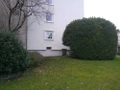
View towards the hash from the street.
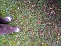
An other nice patch of grass at a hash.

200° some thing view. Or was it just 180°?
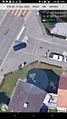
The app shows I'm very close - and jumps away.
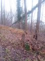
Tree in panic


Achievements
Tungmar earned the No Ribbon Achievement
|