Difference between revisions of "2020-12-31 47 8"
([live] Made it) |
m (→Audio) |
||
| (12 intermediate revisions by 2 users not shown) | |||
| Line 1: | Line 1: | ||
| − | + | {{meetup graticule | |
| − | |||
| − | |||
| − | |||
| − | |||
| − | |||
| − | |||
| − | |||
| − | |||
| lat=47 | | lat=47 | ||
| lon=8 | | lon=8 | ||
| Line 14: | Line 6: | ||
__NOTOC__ | __NOTOC__ | ||
== Location == | == Location == | ||
| − | + | Next to a track inside the Shielwald in Zürich, Switzerland, Earth. | |
| + | |||
| + | (Wald is German for forest and Shiel is the name of the river flowing through this forest.) | ||
== Participants == | == Participants == | ||
| − | + | * +M | |
| − | + | * [[User:Tungmar|Tungmar]] ([[User talk:Tungmar|talk]]) | |
== Plans == | == Plans == | ||
| − | + | Take the train to Langnau-Gattikon and walk to the hash. Then take a train back from Shilwald. Or do it the other way around. | |
== Expedition == | == Expedition == | ||
| − | + | To the today's hash I went on a nice little stroll together with +M. It was cold but peaceful - until we came close to the hash. It was near to a highway and very noisy. Boldly we made two failing attempts to reach the hash in a thick with small needle trees overgrown area before we managed to reached spot. Not much to see here except trees and a tiny bit of the highway. | |
| − | + | But it was a great spot for a first kiss at a hash! | |
| − | |||
| − | |||
| − | |||
| − | |||
== Photos == | == Photos == | ||
| − | |||
| − | |||
| − | |||
<gallery perrow="5"> | <gallery perrow="5"> | ||
| + | Image:2020-12-31 47 8 View from top.jpeg | View from above, the hash is actually a little bit to the left. | ||
| + | Image:2020-12-31 47 8 No Passing.jpeg | Didn't want to pass here, so return. | ||
| + | Image:2020-12-31 47 8 Passing.jpeg | Not much better, but let's go. | ||
| + | Image:2020-12-31 47 8 Foots at the hash.jpeg | Foots at the hash | ||
| + | Image:2020-12-31 47 8 Hashshot.jpeg | | ||
| + | Image:2020-12-31 47 8 View S.jpeg | View South: Trees | ||
| + | Image:2020-12-31 47 8 View N.jpeg | View North: Trees + Higway | ||
| + | Image:2020-12-31 47 8 View Trees.jpeg | View more Trees | ||
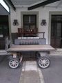
| + | Image:2020-12-31 47 8 Tiger.jpeg | This is called a small tiger in Switzerland... | ||
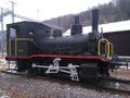
| + | Image:2020-12-31 47 8 Trainstation.jpeg | The train station Shilwald is still operated with muscle power!? | ||
</gallery> | </gallery> | ||
| + | |||
| + | == Audio == | ||
| + | This was my noisiest hash ever - in the middle of the forest. But there is a highway passing by near it. If you like hare noise in the nature, have fun with the short audio sample: [[File:2020-12-31 47 8 Noise.ogg | Noise]] | ||
== Achievements == | == Achievements == | ||
{{#vardefine:ribbonwidth|800px}} | {{#vardefine:ribbonwidth|800px}} | ||
| − | + | {{Land geohash | latitude=47 | longitude=8 | date=2020-12-31 | name=+M}} | |
| + | {{Public transport geohash | latitude=47 | longitude=8 | date=2020-12-31 | name=+M}} | ||
| − | |||
| − | |||
| − | |||
| − | |||
| − | |||
| − | |||
| − | |||
| − | |||
| − | |||
| − | |||
| − | |||
| − | |||
| − | |||
| − | |||
[[Category:Expeditions]] | [[Category:Expeditions]] | ||
| − | |||
[[Category:Expeditions with photos]] | [[Category:Expeditions with photos]] | ||
| − | [[Category:Expeditions with | + | [[Category:Expeditions with audio]] |
| − | |||
| − | |||
| − | |||
| − | |||
[[Category:Coordinates reached]] | [[Category:Coordinates reached]] | ||
| − | + | {{location|CH|ZH}} | |
| − | |||
| − | |||
| − | |||
| − | |||
| − | |||
| − | |||
| − | |||
| − | |||
| − | |||
| − | |||
| − | |||
| − | |||
| − | |||
| − | |||
| − | |||
| − | |||
| − | |||
Latest revision as of 11:52, 2 January 2021
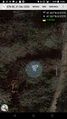
| Thu 31 Dec 2020 in 47,8: 47.2669217, 8.5719948 geohashing.info google osm bing/os kml crox |
Location
Next to a track inside the Shielwald in Zürich, Switzerland, Earth.
(Wald is German for forest and Shiel is the name of the river flowing through this forest.)
Participants
Plans
Take the train to Langnau-Gattikon and walk to the hash. Then take a train back from Shilwald. Or do it the other way around.
Expedition
To the today's hash I went on a nice little stroll together with +M. It was cold but peaceful - until we came close to the hash. It was near to a highway and very noisy. Boldly we made two failing attempts to reach the hash in a thick with small needle trees overgrown area before we managed to reached spot. Not much to see here except trees and a tiny bit of the highway. But it was a great spot for a first kiss at a hash!
Photos
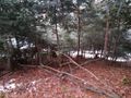
View from above, the hash is actually a little bit to the left.
Didn't want to pass here, so return.
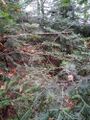
Not much better, but let's go.
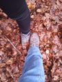
Foots at the hash
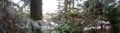
View South: Trees
View North: Trees + Higway
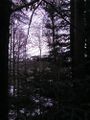
View more Trees
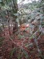
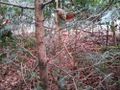
This is called a small tiger in Switzerland...
The train station Shilwald is still operated with muscle power!?


Audio
This was my noisiest hash ever - in the middle of the forest. But there is a highway passing by near it. If you like hare noise in the nature, have fun with the short audio sample:
Achievements
+M earned the Land geohash achievement
|
+M earned the Public transport geohash achievement
|