Difference between revisions of "2020-12-31 48 7"
From Geohashing
(→Plans) |
(→Achievements: Update bicycle distance) |
||
| (One intermediate revision by the same user not shown) | |||
| Line 24: | Line 24: | ||
== Achievements == | == Achievements == | ||
| − | {{#vardefine:ribbonwidth| | + | {{#vardefine:ribbonwidth|100%}} |
{{land geohash | {{land geohash | ||
| latitude = 48 | | latitude = 48 | ||
| Line 36: | Line 36: | ||
| date = 2020-12-31 | | date = 2020-12-31 | ||
| name = [[User:Baarde|Baarde]] | | name = [[User:Baarde|Baarde]] | ||
| − | | distance = | + | | distance = 37 km |
| bothways = true | | bothways = true | ||
}} | }} | ||
Latest revision as of 11:23, 16 August 2021
| Thu 31 Dec 2020 in 48,7: 48.2669217, 7.5719948 geohashing.info google osm bing/os kml crox |
Location
At the edge of a forest in Wittisheim.
Participants
Plans
I was visiting my mother who lives near Sélestat. Wouldn't be nice if there was a geohash on my way home?
Expedition
Photos
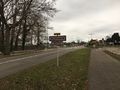
Arriving in Wittisheim
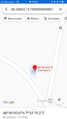
Coordinates reached

Stupid grin
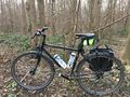
My bicycle at the geohash


Achievements
Baarde earned the Land geohash achievement
|
Baarde earned the Bicycle geohash achievement
|