Difference between revisions of "2021-01-03 47 7"
From Geohashing
(→Photos) |
(reinstating content) |
||
| (2 intermediate revisions by the same user not shown) | |||
| Line 6: | Line 6: | ||
__NOTOC__ | __NOTOC__ | ||
== Location == | == Location == | ||
| − | Near the "Bänggerspitz" | + | Near the "[[wikidata:Q90041058|Bänggerspitz]]" |
== Participants == | == Participants == | ||
*[[User:Kaktus67|Kaktus67]] | *[[User:Kaktus67|Kaktus67]] | ||
| − | |||
| − | |||
| − | |||
== Expedition == | == Expedition == | ||
| − | + | It seems that Kaktus67 reached the coordinates, having provided a picture of the Geohash. | |
| − | |||
| − | |||
| − | |||
== Photos == | == Photos == | ||
| − | |||
| − | |||
| − | |||
<gallery perrow="5"> | <gallery perrow="5"> | ||
2021-01-03 47 7 a the hash.jpg | at the hash | 2021-01-03 47 7 a the hash.jpg | at the hash | ||
| Line 32: | Line 23: | ||
<!-- Add any achievement ribbons you earned below, or remove this section --> | <!-- Add any achievement ribbons you earned below, or remove this section --> | ||
| − | |||
| − | |||
| − | |||
| − | |||
| − | |||
| − | |||
| − | |||
| − | |||
| − | |||
| − | |||
| − | |||
| − | |||
| − | |||
| − | |||
[[Category:Expeditions]] | [[Category:Expeditions]] | ||
| − | |||
[[Category:Expeditions with photos]] | [[Category:Expeditions with photos]] | ||
| − | |||
| − | |||
| − | |||
| − | |||
| − | |||
[[Category:Coordinates reached]] | [[Category:Coordinates reached]] | ||
| − | |||
| − | |||
| − | |||
| − | |||
| − | |||
| − | |||
| − | |||
| − | |||
| − | |||
| − | |||
| − | |||
| − | |||
| − | |||
| − | |||
| − | |||
| − | |||
| − | |||
| − | |||
{{location|FR|68}} | {{location|FR|68}} | ||
Latest revision as of 15:17, 31 March 2021
| Sun 3 Jan 2021 in 47,7: 47.5207822, 7.5010263 geohashing.info google osm bing/os kml crox |
Location
Near the "Bänggerspitz"
Participants
Expedition
It seems that Kaktus67 reached the coordinates, having provided a picture of the Geohash.
Photos
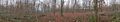
at the hash