Difference between revisions of "2021-01-03 47 8"
m (Fippe moved page 2021-01-03 47 8 to 2021-01-03 47 7: These coordinates are near the Bänggespitz.) |
(→Expedition) |
||
| (11 intermediate revisions by 3 users not shown) | |||
| Line 1: | Line 1: | ||
| − | + | {{meetup graticule | |
| − | |||
| − | |||
| − | |||
| − | |||
| − | |||
| − | |||
| − | |||
| − | |||
| lat=47 | | lat=47 | ||
| lon=8 | | lon=8 | ||
| date=2021-01-03 | | date=2021-01-03 | ||
| − | }} | + | }} |
__NOTOC__ | __NOTOC__ | ||
== Location == | == Location == | ||
| − | + | In a small forest near Hochfelden, Zürich, Switzerland, Earth. | |
== Participants == | == Participants == | ||
| − | + | * [[User:Tungmar|Tungmar]] ([[User talk:Tungmar|talk]]) | |
| − | |||
== Plans == | == Plans == | ||
| − | + | *I'm planing a small pick-nick here at around 14:00. -- [[User:Tungmar|Tungmar]] ([[User talk:Tungmar|talk]]) 11:24, 3 January 2021 (GMT+01:00) | |
== Expedition == | == Expedition == | ||
| − | + | I took the wrong bus. At the train station in Oberglatt ZH both bus lines 525 and 535 run. At the same time. From the same platform. With the same final destination. The destination is written on the bus and shown in the time table app I used. | |
| + | |||
| + | 535 just arrived when I reached the platform and I jumped in, busy finishing planing my walking route. The first stop was correct, but then the bus started to move further and further away from where I wanted to go. I had a while to realize what went wrong. I should have taken 525 but took 535 which takes a longer route and arrives way later near the hash. I got off the bus in Dielsdorf, found a GeoCache and some numbers for Multicaches, took a train back and an other to Bülach where I boarded an other bus 535 and arrived at the hash just at 14:00. | ||
| + | |||
| + | It forest is a rough managed forest and not very inviting. I searched for the hash in the mid of low thorn ranks and tree stumps and located it at a not very inviting place next to thorns and overgrown with a small tree. I prepared and photographed my picnic there but ended up eating my Gim-Bab a few meters away where I could properly sit. | ||
| + | After I went back to have a look at the wired house on the edge of the forest and found it is a shooting range. Luckily no one used it at the time. Back to the forest, creating a track for OSM with all the unmapped tracks in this small forest. Then I went on for some more GeoCaches. | ||
| − | + | On the way I picked up a GeoKrety and some trash and made a picture at a geocache containing a camera. Ironically I may have not only had picked up a Corona-Beer bottle that day but also the virus with the same name. To bad I can't photograph this tiny little raptors for a microscopic-raptor-attack-achievement! | |
| − | |||
| − | |||
== Photos == | == Photos == | ||
| − | |||
| − | |||
| − | |||
<gallery perrow="5"> | <gallery perrow="5"> | ||
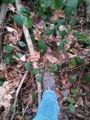
| + | Image:2021-01-03 47 8 Hash.jpeg | Not so comfy hash | ||
| + | Image:2021-01-03 47 8 Hashshot.jpeg | | ||
| + | Image:2021-01-03 47 8 View 1.jpeg | Rough forest | ||
| + | Image:2021-01-03 47 8 View 2.jpeg | More rough forest | ||
| + | Image:2021-01-03 47 8 김밥.jpeg | Gim-Bab picnic. Testy! | ||
| + | Image:2021-01-03 47 8 Building.jpeg | Building near the hash | ||
| + | Image:2021-01-03 47 8 Building 2.jpeg | The building is a shooting range | ||
| + | Image:2021-01-03 47 8 Mural.jpeg | Mural at the building | ||
| + | Image:2021-01-03 47 8 Bench.jpeg | That's nice upcycling! | ||
| + | Image:2021-01-03 47 8 Krety.jpeg | Grinning GeoKrety with collected trash. | ||
</gallery> | </gallery> | ||
== Achievements == | == Achievements == | ||
{{#vardefine:ribbonwidth|800px}} | {{#vardefine:ribbonwidth|800px}} | ||
| − | + | {{Picnic_geohash|latitude=47|longitude=8|date=2021-01-03|name=[[User:Tungmar|Tungmar]]|image=2021-01-03 47 8 김밥.jpeg|food=Gim-Bab}} | |
| − | |||
| − | |||
| − | |||
| − | |||
| − | |||
| − | |||
| − | |||
| − | |||
| − | |||
| − | |||
| − | |||
| − | |||
| − | |||
| − | |||
[[Category:Expeditions]] | [[Category:Expeditions]] | ||
| − | |||
[[Category:Expeditions with photos]] | [[Category:Expeditions with photos]] | ||
| − | |||
| − | |||
| − | |||
| − | |||
| − | |||
[[Category:Coordinates reached]] | [[Category:Coordinates reached]] | ||
| − | + | {{location|CH|ZH}} | |
| − | |||
| − | |||
| − | |||
| − | |||
| − | |||
| − | |||
| − | |||
| − | |||
| − | |||
| − | |||
| − | |||
| − | |||
| − | |||
| − | |||
| − | |||
| − | |||
| − | |||
Latest revision as of 10:17, 22 May 2021
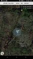
| Sun 3 Jan 2021 in 47,8: 47.5207822, 8.5010263 geohashing.info google osm bing/os kml crox |
Location
In a small forest near Hochfelden, Zürich, Switzerland, Earth.
Participants
Plans
- I'm planing a small pick-nick here at around 14:00. -- Tungmar (talk) 11:24, 3 January 2021 (GMT+01:00)
Expedition
I took the wrong bus. At the train station in Oberglatt ZH both bus lines 525 and 535 run. At the same time. From the same platform. With the same final destination. The destination is written on the bus and shown in the time table app I used.
535 just arrived when I reached the platform and I jumped in, busy finishing planing my walking route. The first stop was correct, but then the bus started to move further and further away from where I wanted to go. I had a while to realize what went wrong. I should have taken 525 but took 535 which takes a longer route and arrives way later near the hash. I got off the bus in Dielsdorf, found a GeoCache and some numbers for Multicaches, took a train back and an other to Bülach where I boarded an other bus 535 and arrived at the hash just at 14:00.
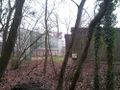
It forest is a rough managed forest and not very inviting. I searched for the hash in the mid of low thorn ranks and tree stumps and located it at a not very inviting place next to thorns and overgrown with a small tree. I prepared and photographed my picnic there but ended up eating my Gim-Bab a few meters away where I could properly sit.
After I went back to have a look at the wired house on the edge of the forest and found it is a shooting range. Luckily no one used it at the time. Back to the forest, creating a track for OSM with all the unmapped tracks in this small forest. Then I went on for some more GeoCaches.
On the way I picked up a GeoKrety and some trash and made a picture at a geocache containing a camera. Ironically I may have not only had picked up a Corona-Beer bottle that day but also the virus with the same name. To bad I can't photograph this tiny little raptors for a microscopic-raptor-attack-achievement!
Photos
Not so comfy hash

Rough forest

More rough forest
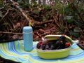
Gim-Bab picnic. Testy!
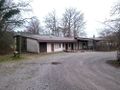
Building near the hash
The building is a shooting range

Mural at the building
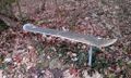
That's nice upcycling!
Grinning GeoKrety with collected trash.


Achievements
Tungmar earned the Picnic achievement
|