Difference between revisions of "2021-01-04 53 9"
Gumbledalf (talk | contribs) |
(→Photos: now correct) |
||
| (2 intermediate revisions by 2 users not shown) | |||
| Line 5: | Line 5: | ||
==Participants== | ==Participants== | ||
| − | *[[User:π π π|π π π]] ([[User talk: | + | *[[User:π π π|π π π]] ([[User talk:π π π|talk]]) |
| − | |||
| − | |||
| − | |||
| − | |||
==Expedition== | ==Expedition== | ||
| − | + | I rode the train to Wiemersdorf for 30 minutes, then cycled 3.4 km to the hashpoint, the last part along a very muddy dirt road. The hash lay 80 m onto a huge field that was covered in low grass. I found the coordinates and took pictures (which went much faster than previously because of my new phone). I had 20 minutes waiting time and didn't want to spend them at the station, so I explored the forest at the edge of the field, enjoying its quietness and serenity and trying to find a loud woodpecker (to no avail). Then I walked back 250 m to my bike, cycled to the station and took the train home. | |
==Photos== | ==Photos== | ||
| − | + | <gallery> | |
| − | <gallery | + | File:2021-01-04 53 9 c.jpg | coords |
| + | File:2021-01-04 53 9 p.jpg | proof | ||
| + | File:20210104_152031.jpg | stupid grin | ||
| + | File:20210104_152043.jpg | pano | ||
| + | File:20210104_152117.jpg | the hash | ||
| + | File:20210104_152133.jpg | the meadow | ||
</gallery> | </gallery> | ||
| Line 22: | Line 23: | ||
Land geohash, Bicycle geohash, Public transport geohash | Land geohash, Bicycle geohash, Public transport geohash | ||
| − | __NOTOC__ | + | __NOTOC__ |
[[Category:Expeditions]] | [[Category:Expeditions]] | ||
| − | + | [[Category:Coordinates reached]] | |
[[Category:Land geohash achievement]] | [[Category:Land geohash achievement]] | ||
[[Category:Bicycle geohash achievement]] | [[Category:Bicycle geohash achievement]] | ||
| − | [[Category:Public transport geohash achievement]] | + | [[Category:Public transport geohash achievement]] |
{{location|DE|SH|SE}} | {{location|DE|SH|SE}} | ||
Latest revision as of 17:42, 6 September 2022
| Mon 4 Jan 2021 in 53,9: 53.9607634, 9.8777716 geohashing.info google osm bing/os kml crox |
Location
on a field in Wiemersdorf, Schleswig-Holstein
Participants
Expedition
I rode the train to Wiemersdorf for 30 minutes, then cycled 3.4 km to the hashpoint, the last part along a very muddy dirt road. The hash lay 80 m onto a huge field that was covered in low grass. I found the coordinates and took pictures (which went much faster than previously because of my new phone). I had 20 minutes waiting time and didn't want to spend them at the station, so I explored the forest at the edge of the field, enjoying its quietness and serenity and trying to find a loud woodpecker (to no avail). Then I walked back 250 m to my bike, cycled to the station and took the train home.
Photos

coords

proof
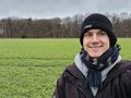
stupid grin
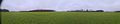
pano
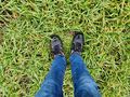
the hash
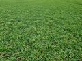
the meadow


Achievements
Land geohash, Bicycle geohash, Public transport geohash