Difference between revisions of "2021-01-09 52 5"
From Geohashing
(Created page with "{{subst:Expedition}}") |
|||
| Line 14: | Line 14: | ||
__NOTOC__ | __NOTOC__ | ||
== Location == | == Location == | ||
| − | + | In National Park "De Utrechtse Heuvelrug", near Soesterberg. According to the map, the hash was close to an intersection of a footpath and a bridle path. | |
== Participants == | == Participants == | ||
| − | + | [[User:Xnyhps|Xnyhps]] ([[User talk:Xnyhps|talk]]) | |
| − | |||
== Plans == | == Plans == | ||
| − | + | Cycle along the Verlengde Slotlaan, then continue on foot into the forest to get as close as possible. | |
== Expedition == | == Expedition == | ||
<!-- how it all turned out. your narrative goes here. --> | <!-- how it all turned out. your narrative goes here. --> | ||
| − | |||
| − | |||
| − | |||
== Photos == | == Photos == | ||
| Line 34: | Line 30: | ||
--> | --> | ||
<gallery perrow="5"> | <gallery perrow="5"> | ||
| + | Image:2021-01-09 52 5 Proof.png | GPS proof | ||
</gallery> | </gallery> | ||
== Achievements == | == Achievements == | ||
{{#vardefine:ribbonwidth|800px}} | {{#vardefine:ribbonwidth|800px}} | ||
| − | |||
| − | |||
| − | |||
| − | |||
| − | |||
| − | |||
| − | |||
| − | |||
| − | |||
| − | |||
| − | |||
| − | |||
| − | |||
| − | |||
[[Category:Expeditions]] | [[Category:Expeditions]] | ||
| − | + | [[Category:Coordinates reached]] | |
[[Category:Expeditions with photos]] | [[Category:Expeditions with photos]] | ||
| − | |||
[[Category:Expedition without GPS]] | [[Category:Expedition without GPS]] | ||
| − | |||
| − | |||
| − | |||
| − | |||
| − | |||
| − | |||
| − | |||
| − | |||
| − | |||
| − | |||
| − | |||
| − | |||
| − | |||
| − | |||
| − | |||
| − | |||
| − | |||
| − | |||
| − | |||
| − | |||
| − | |||
| − | |||
Revision as of 14:49, 9 January 2021
| Sat 9 Jan 2021 in 52,5: 52.1082552, 5.2832894 geohashing.info google osm bing/os kml crox |
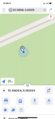
Location
In National Park "De Utrechtse Heuvelrug", near Soesterberg. According to the map, the hash was close to an intersection of a footpath and a bridle path.
Participants
Plans
Cycle along the Verlengde Slotlaan, then continue on foot into the forest to get as close as possible.
Expedition
Photos
GPS proof
