Difference between revisions of "2021-01-17 44 -76"
From Geohashing
(success!) |
|||
| Line 6: | Line 6: | ||
== Location == | == Location == | ||
| − | |||
Public park in Kingston, ON. | Public park in Kingston, ON. | ||
| Line 16: | Line 15: | ||
Drive there, potentially with Dad. | Drive there, potentially with Dad. | ||
| − | [[Category: | + | == Expedition == |
| + | === [[User:SIGSTKFLT|SIGSTKFLT]] === | ||
| + | {{#vardefine:ribbontheme|mini}} | ||
| + | We drove there. | ||
| + | {{Land geohash|latitude=44|longitude=-76|date=2021-01-17}} | ||
| + | [[Category:Expeditions]] | ||
| + | [[Category:Expeditions with photos]] | ||
| + | [[Category:Coordinates reached]] | ||
| + | |||
| + | == Photos == | ||
| + | === [[User:SIGSTKFLT|SIGSTKFLT]] === | ||
| + | We drove there. | ||
| + | <gallery perrow="5"> | ||
| + | File:SIGSTKFLT 2021-01-17 44 -76 sig.jpg | SIG looking particularly stupid with their pants falling down. | ||
| + | SIGSTKFLT 2021-01-17 44 -76 dad.jpg | SIG's dad & the sign | ||
| + | </gallery> | ||
| + | |||
{{location|CA|ON|FR}} | {{location|CA|ON|FR}} | ||
Revision as of 22:34, 17 January 2021
| Sun 17 Jan 2021 in 44,-76: 44.2391942, -76.4983111 geohashing.info google osm bing/os kml crox |
Contents
Location
Public park in Kingston, ON.
Participants
Plans
SIGSTKFLT
Drive there, potentially with Dad.
Expedition
SIGSTKFLT
We drove there.
| Land geohash achievement by reaching the (44, -76) geohash on 2021-01-17. |
Photos
SIGSTKFLT
We drove there.
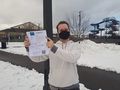
SIG looking particularly stupid with their pants falling down.
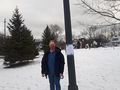
SIG's dad & the sign

