Difference between revisions of "2021-01-17 50 7"
Gefrierbrand (talk | contribs) |
Gefrierbrand (talk | contribs) |
||
| (7 intermediate revisions by 2 users not shown) | |||
| Line 15: | Line 15: | ||
== Location == | == Location == | ||
<!-- where you've surveyed the hash to be --> | <!-- where you've surveyed the hash to be --> | ||
| + | In front of an oak on the way from Pfaffenheck towards Alken. | ||
== Participants == | == Participants == | ||
| − | + | * [[User:Gefrierbrand|Gefrierbrand]] | |
| − | + | * [[user:santu|Santu]] | |
| + | * Pedro the dog | ||
== Plans == | == Plans == | ||
| Line 24: | Line 26: | ||
== Expedition == | == Expedition == | ||
| − | + | This was another great and fun expedition. We started slightly behind schedule and drove to Pfaffenheck in light snowfall. We could not get as close to the Grillhütte (barbecue hut) as Google Maps told us as the road was closed for vehicles of any kind. So we chose a parking spot not far from it and walked towards the original intended starting point. | |
| − | + | But even before we reached it, Santu spotted a quite inviting rope-bridge over the nearby brook and naturally Gefrierbrand had to cross it both ways! | |
| − | + | We then proceeded along the path towards the hash and found it easily just slightly offroad. As there was plenty of snow all around us, we managed to build a nice snowman using a carrot as nose which we had brought along especially for that purpose. We also had hopes to claim the frozen achievement, and the car showed exactly 0°C on the road, but the thermometer we brought along only got down to 2°C at the hashpoint. | |
| + | |||
| + | After the relatively short walk towards the hash we proceeded about 4km further along the path all the way downhill towards Alken and visited the castle Thurant, which was unfortunately closed due to Covid. The view was nice nonetheless. We then headed back the way we came, this time only uphill! Our snowman was still standing as we passed the hashpoint again. The second temperature reading was still at 2°C, so we have to try again for that one. | ||
== Photos == | == Photos == | ||
| − | |||
| − | |||
| − | |||
<gallery perrow="5"> | <gallery perrow="5"> | ||
| + | File:2021-01-17_50_7_Proof.jpg | Coordinates reached | ||
| + | File:2021-01-17_50_7_snowman.jpg | The snowman | ||
| + | File:2021-01-17_50_7_stupidgrin.jpg | obligatory StupidGrin<sup>TM</sup> | ||
| + | File:2021-01-17_50_7_thurant.jpg | Castle Thurant... | ||
| + | File:2021-01-17_50_7_stupidgrinatthurant.jpg | ...with stupid grin there. | ||
</gallery> | </gallery> | ||
== Achievements == | == Achievements == | ||
{{#vardefine:ribbonwidth|800px}} | {{#vardefine:ribbonwidth|800px}} | ||
| − | + | {{land geohash | |
| + | | latitude = 50 | ||
| + | | longitude = 7 | ||
| + | | date = 2021-01-17 | ||
| + | | name = Gefrierbrand & Santu | ||
| + | }} | ||
| + | {{snowman geohash | ||
| + | | latitude = 50 | ||
| + | | longitude = 7 | ||
| + | | date = 2021-01-17 | ||
| + | | name = Gefrierbrand & Santu | ||
| + | }} | ||
| − | |||
| − | |||
| − | |||
| − | |||
| − | |||
| − | |||
| − | |||
| − | |||
[[Category:Expeditions]] | [[Category:Expeditions]] | ||
| − | |||
[[Category:Expeditions with photos]] | [[Category:Expeditions with photos]] | ||
| − | |||
| − | |||
| − | |||
| − | |||
| − | |||
[[Category:Coordinates reached]] | [[Category:Coordinates reached]] | ||
| − | + | [[Category:Expeditions with dogs]] | |
| − | + | {{location|DE|RP|MYK}} | |
| − | |||
| − | |||
| − | |||
| − | |||
| − | |||
| − | |||
| − | |||
| − | |||
| − | |||
| − | |||
| − | [[Category: | ||
| − | |||
| − | |||
| − | |||
| − | |||
| − | |||
Latest revision as of 07:53, 18 October 2022
| Sun 17 Jan 2021 in 50,7: 50.2391942, 7.4983111 geohashing.info google osm bing/os kml crox |
Location
In front of an oak on the way from Pfaffenheck towards Alken.
Participants
- Gefrierbrand
- Santu
- Pedro the dog
Plans
We plan to be there around 13:00 walking there from the nearby "Grillhütte" in Pfaffenheck
Expedition
This was another great and fun expedition. We started slightly behind schedule and drove to Pfaffenheck in light snowfall. We could not get as close to the Grillhütte (barbecue hut) as Google Maps told us as the road was closed for vehicles of any kind. So we chose a parking spot not far from it and walked towards the original intended starting point.
But even before we reached it, Santu spotted a quite inviting rope-bridge over the nearby brook and naturally Gefrierbrand had to cross it both ways! We then proceeded along the path towards the hash and found it easily just slightly offroad. As there was plenty of snow all around us, we managed to build a nice snowman using a carrot as nose which we had brought along especially for that purpose. We also had hopes to claim the frozen achievement, and the car showed exactly 0°C on the road, but the thermometer we brought along only got down to 2°C at the hashpoint.
After the relatively short walk towards the hash we proceeded about 4km further along the path all the way downhill towards Alken and visited the castle Thurant, which was unfortunately closed due to Covid. The view was nice nonetheless. We then headed back the way we came, this time only uphill! Our snowman was still standing as we passed the hashpoint again. The second temperature reading was still at 2°C, so we have to try again for that one.
Photos
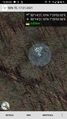
Coordinates reached
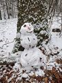
The snowman
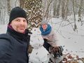
obligatory StupidGrinTM
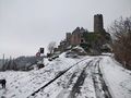
Castle Thurant...

...with stupid grin there.


Achievements
Gefrierbrand & Santu earned the Land geohash achievement
|
Gefrierbrand & Santu earned the Snowman Geohash Achievement
|